Unsettled Through Tomorrow Night; A Few Strong/Severe Storms
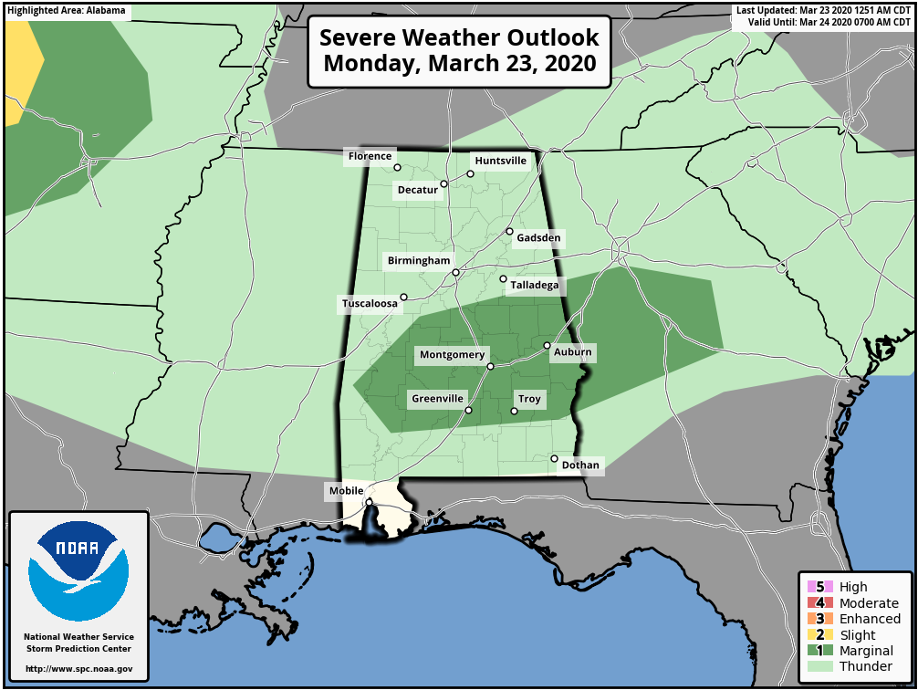
STORMY START: Rain and thunderstorms are moving through the northern half of Alabama early this morning; the storm produced hail and strong winds over parts of Fayette and Walker counties. As I write this they are weakening as they move into the Birmingham metro. Additional showers and storms are likely today, and by this afternoon the stronger storms will be over the central counties of the state, where SPC has defined a low end, “marginal risk” (level 1/5) of severe thunderstorms.
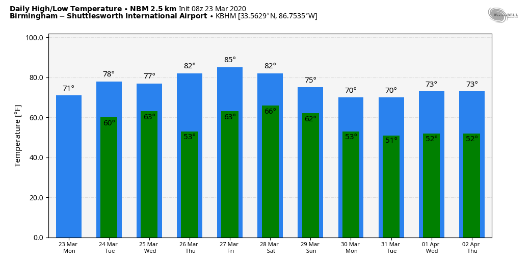
Otherwise today will be cloudy with a high between 69 and 72 across North/Central Alabama.
TOMORROW: The morning should be quiet with just a few isolated showers, but heavier storms are possible during the afternoon and evening hours over the northern part of Alabama. There is a “slight risk” (level 2/5) over the Tennessee Valley (including places like Athens, Muscle Shoals, and Russellville), and a “marginal risk” (level 1/5) as far south as Tuscaloosa, Columbiana, and Heflin.
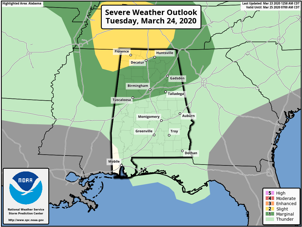
The main window for heavier storms will come from 3:00 until 9:00 p.m… hail and strong winds will be possible. An isolated tornado can’t be ruled out, especially over the Tennessee Valley of far North Alabama in the “slight risk” area.
See this statement from the NWS/ADPH concerning tornado sheltering during the COVID-19 crisis.
REST OF THE WEEK: The weather should be rain-free across Alabama Wednesday through Friday with warm afternoons. Look for low 80s Thursday, and mid 80s Friday, our warmest weather so far in 2020. Sunny days, fair nights.
THE ALABAMA WEEKEND: Saturday will be another warm, dry day with a high in the 80s, but a cold front will bring showers and storms back into the state Sunday. A few strong storms will be possible.
NEXT WEEK: The first half of the week looks mild and dry with highs in the 70s; showers and storms should return by Thursday or Friday. See the Weather Xtreme video for maps, graphics, and more details.
ON THIS DATE IN 1932: Clean-up continued after a superoutbreak of tornadoes on March 21 across the Deep South. The 1932 outbreak produced 10 violent tornadoes, classified EF4 or EF5 on the Fujita scale of tornado intensity, eight of which occurred in Alabama alone, and is surpassed only by the March 1952 tornado outbreak, with 11 violent tornadoes; the 2011 Super Outbreak, with 15; the 1965 Palm Sunday tornado outbreak, with 17; and the 1974 Super Outbreak, with 30. Nobody knows exactly how many died in Alabama, but the death toll was at least 268. Thousands more were injured. Some of the hardest hit counties included Tuscaloosa, Talladega, Cullman, Chilton, Marengo, Clay, Shelby, and Perry. Near Faunsdale on U.S. 80 in Northeast Marengo County east of Demopolis (one of the first towns hit), the owner of an 800-acre plantation found a horse collar, a dead pig and the body of a three-year-old child all jammed together in a hollow tree stump. The child and the pig were both dead.
BEACH FORECAST: Click here to see the AlabamaWx Beach Forecast Center page.
WEATHER BRAINS: Don’t forget you can listen to our weekly 90 minute show anytime on your favorite podcast app. This is the show all about weather featuring many familiar voices, including our meteorologists here at ABC 33/40.
CONNECT: You can find me on all of the major social networks…
Facebook
Twitter
Instagram
Pinterest
Snapchat: spannwx
Look for the next Weather Xtreme video by 4:00 this afternoon… enjoy the day!
Category: Alabama's Weather, ALL POSTS, Weather Xtreme Videos
About the Author (Author Profile)
James Spann is one of the most recognized and trusted television meteorologists in the industry. He holds the AMS CCM designation and television seals from the AMS and NWA. He is a past winner of the Broadcast Meteorologist of the Year from both professional organizations.Subscribe
If you enjoyed this article, subscribe to receive more just like it.


