Rotation Showing Up On Cell Heading Toward Colbert County
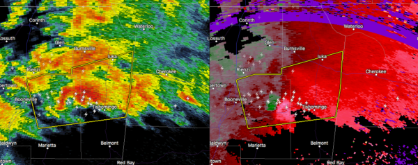
A severe thunderstorm is starting to show signs of rotation as it moves east-northeast at 50 MPH. As of now, the main threat with this cell is damaging winds up to 60 MPH and hail up to 1-inch in diameter.
It actually just went tornado warned as I am typing this post.
People in western Colbert County will need to watch this storm as it continues to move into more unstable air. Heads up for the cities of Cherokee, Tuscumbia, Florence, and Muscle Shoals.
Category: Alabama's Weather, ALL POSTS, Severe Weather
About the Author (Author Profile)
Scott Martin is an operational meteorologist, professional graphic artist, musician, husband, and father. Not only is Scott a member of the National Weather Association, but he is also the Central Alabama Chapter of the NWA president. Scott is also the co-founder of Racecast Weather, which provides forecasts for many racing series across the USA. He also supplies forecasts for the BassMaster Elite Series events including the BassMaster Classic.Subscribe
If you enjoyed this article, subscribe to receive more just like it.


