Cool, Dry Weather Continues
COLD MORNING: Here are some temperatures just before sunrise across the great state of Alabama early this morning.
Haleyville 32
Black Creek 33
Decatur 33
Cullman 33
Huntsville 35
Birmingham 37
Weaver 37
Hueytown 37
Bessemer 38
Gadsden 39
Muscle Shoals 39
Heflin 39
Cottondale 39
Anniston 41
Tuscaloosa 41
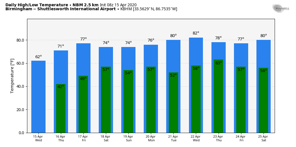
Today will be sunny with a high between 60 and 64; the average high for Birmingham on April 15 is 74. Tonight will be clear and cold again; lows will range from 35 to 43, and colder pockets will have the risk of frost again. The good news is that for just about everyone in the state tomorrow morning will be the last frost until sometime in October.
Tomorrow will be another sunny day with a high in the low 70s.
FRIDAY AND THE WEEKEND: The weather Friday will stay dry; with a partly sunny sky look for a high in the mid 70s. Clouds move in Friday night ahead of cold front, and some rain seems likely late Friday night and every early Saturday morning. The main window for rain comes from midnight Friday night until 6:00 a.m. Saturday; amounts should be 1/4″ or less, and there won’t be any thunder. Most of you will sleep through it.
Then, during the day Saturday, the sky becomes partly to mostly sunny with a high between 67 and 70. Clouds increase Saturday night as the front near the Gulf Coast begins to slowly lift northward, and periods of rain are likely Sunday afternoon and Sunday night. Thunderstorms are possible over the Southern half of Alabama, but for now the severe weather risk looks low. Sunday’s high will stay in the upper 60s.
NEXT WEEK: Monday and Tuesday look dry and mild; then global models indicate a dynamic weather system for Wednesday night/Thursday that will bring some potential for strong, possibly severe thunderstorms to Alabama. Way too early to be specific; just something to watch for now. See the Weather Xtreme video for maps, graphics, and more details.
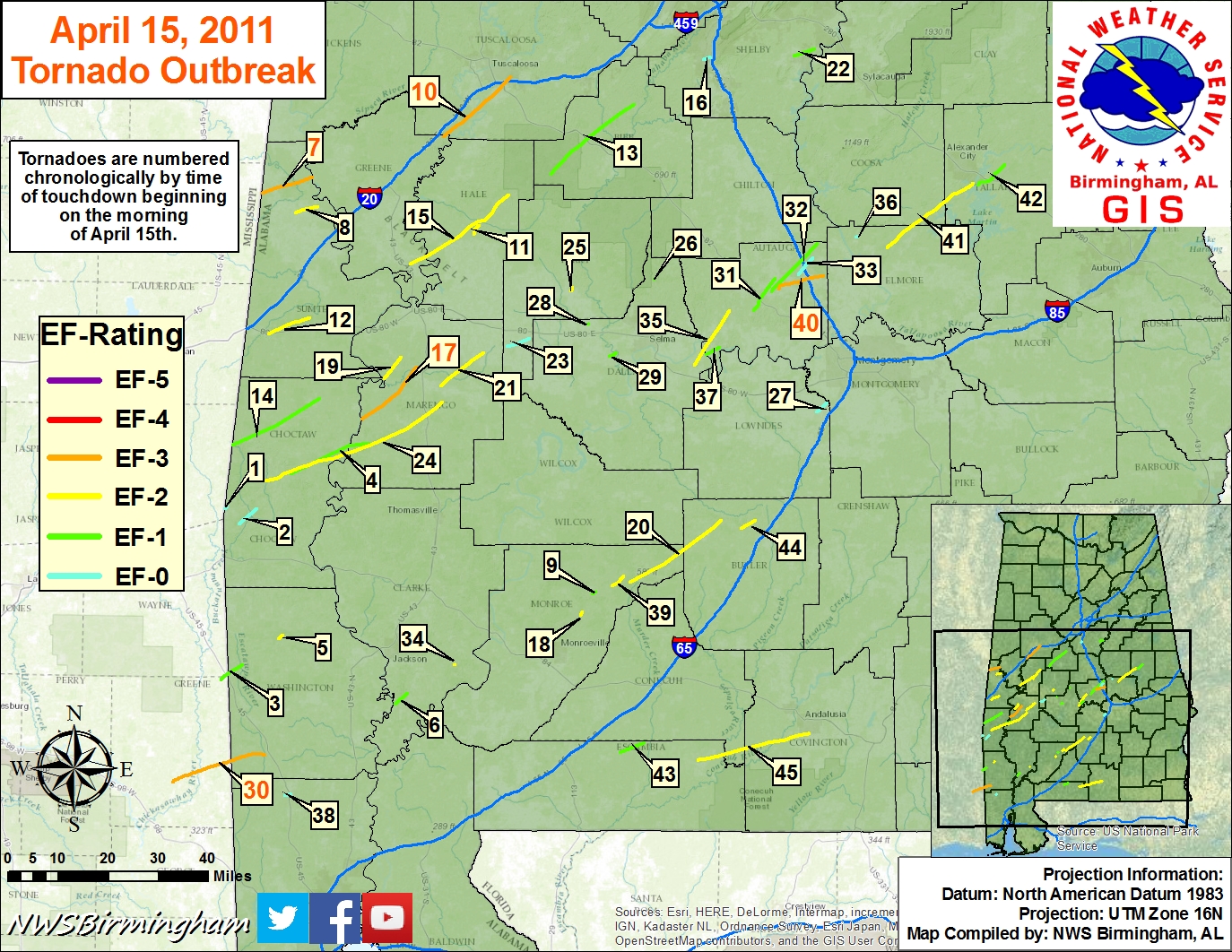
ON THIS DATE IN 2011: The “forgotten” tornado outbreak. One of the large EF-3 tornadoes to strike Central Alabama on the day created a swath of damage from northeastern Greene County, just southeast of the community of Ralph, to just south of Veterans Memorial Parkway just east of Tuscaloos in south-central Tuscaloosa County. Winds with this monster were estimated at 140 MPH, mainly uprooting and snapping trees. A few homes and businesses received damage as the twister moved north of Shelton State Community College and crossed Alabama Highway 69 near Taylorville, and crossing I-20/59 near Alabama Highway 82.
Throughout the day, 45 tornado warnings and 19 severe thunderstorm warnings were issued for Central Alabama. Out of the 29 confirmed tornadoes, the total damage path length was over 244 miles, with 10 of those tornadoes having damage paths over 10 miles long. The event was “forgotten” by many due to what would happen 12 days later, on April 27, 2011, when a generational tornado outbreak would kill 252 people in our state.
BEACH FORECAST: Click here to see the AlabamaWx Beach Forecast Center page.
WEATHER BRAINS: Don’t forget you can listen to our weekly 90 minute show anytime on your favorite podcast app. This is the show all about weather featuring many familiar voices, including our meteorologists here at ABC 33/40.
CONNECT: You can find me on all of the major social networks…
Facebook
Twitter
Instagram
Pinterest
Snapchat: spannwx
Look for the next Weather Xtreme video here by 4:00 this afternoon… enjoy the day!
Category: Alabama's Weather, ALL POSTS, Weather Xtreme Videos
About the Author (Author Profile)
James Spann is one of the most recognized and trusted television meteorologists in the industry. He holds the AMS CCM designation and television seals from the AMS and NWA. He is a past winner of the Broadcast Meteorologist of the Year from both professional organizations.Subscribe
If you enjoyed this article, subscribe to receive more just like it.


