

Severe Storms Possible Sunday
ANOTHER NICE DAY AHEAD: Dry air remains in place across Alabama this morning… we expect a good supply of sunshine today with a high in the mid 70s. Clouds will increase tonight ahead of a cold front, and a band of showers will move into the state after midnight. There could be a clap of thunder somewhere, but no risk of severe thunderstorms.
Showers will end very early tomorrow morning, and the sky becomes mostly sunny over the northern half of the stage by afternoon with a high around 70. The front over South Alabama, however, will begin moving northward as a warm front tomorrow night, and clouds will increase.
SEVERE WEATHER THREAT SUNDAY: The warm front should move to near the Tennessee state line by Sunday afternoon, putting much of the state in an unstable airmass. Then, as a wave of low pressure moves along the front, rain and thunderstorms will increase during the afternoon and through Sunday night. SPC has an “enhanced risk” (level 3/5) of severe thunderstorms defined for areas south of a line from Tuscaloosa to Columbiana to Roanoke… with a “slight risk” (level 2/5) as far north as Sulligent, Oneonta, and Cedar Bluff. A “marginal risk” (level 1/5) extends northward to near the Tennessee state line.
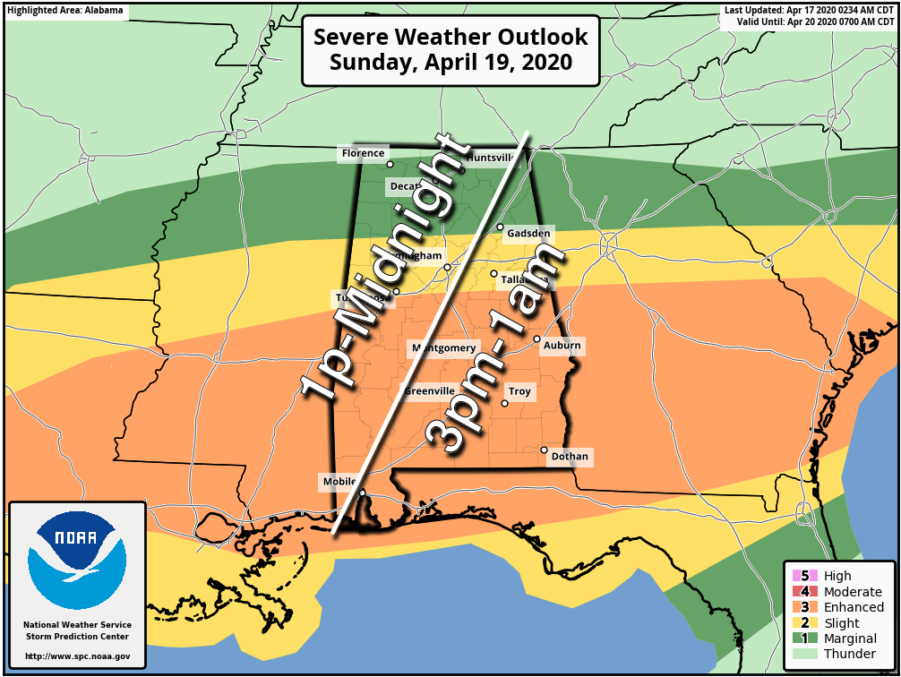
We expect an expansive area of favorable moisture, instability and shear, with numerous severe storms possible Sunday afternoon and Sunday night. One question involves the northward extent of the unstable air; there is a chance the northern quarter of the state remains in rain cooled, stable air through the event.
THREATS: All modes of severe thunderstorms will be possible, including large hail, damaging wind, and a few tornadoes. A strong tornado can’t be ruled out (EF2 or higher), especially over the southern half of the state.
TIMING: There will be multiple waves of rain and storms Sunday and Sunday night, much like the event last Sunday. The core risk of severe storms will come from roughly 1:00 p.m. to 1:00 a.m.
FLOODING: Rain will be heavy at times; amounts of 2-3 inches are likely, with isolated heavier amounts. Flash flooding issues could develop.
This event, most likely, won’t be as productive as the one last Sunday (Alabama had 24 confirmed tornadoes with that event), but this is still a significant threat and everyone will need to be a in a position to hear severe weather warnings, and have a good action plan if you get in a tornado warning polygon. And, don’t forget to pay attention to severe thunderstorm warnings.
NEXT WEEK: Rain ends early Monday, followed by a clearing sky. Tuesday looks dry and mild, and then another dynamic weather system will bring the potential for another round of strong, possibly severe thunderstorms by Wednesday night or Thursday. See the Weather Xtreme video for maps, graphics, and more details.
ON THIS DATE IN 1922: Southern Illinois and Western Indiana saw two rounds of severe weather, including tornadoes. The first significant tornado occurred just before midnight on the 16 near Oakdale, Illinois. This tornado killed 4 and injured 22 others. Five additional tornadoes took place between midnight and 3 AM on the 17. During the mid-morning and early afternoon hours, two estimated F4 tornadoes caused devastation in Hedrick and near Orestes in Indiana. A postcard from one farm near Orestes was dropped near Mt. Cory, Ohio, 124 miles away.
BEACH FORECAST: Click here to see the AlabamaWx Beach Forecast Center page.
WEATHER BRAINS: Don’t forget you can listen to our weekly 90 minute show anytime on your favorite podcast app. This is the show all about weather featuring many familiar voices, including our meteorologists here at ABC 33/40.
CONNECT: You can find me on all of the major social networks…
Facebook
Twitter
Instagram
Pinterest
Snapchat: spannwx
Look for the next Weather Xtreme video here by 4:00 this afternoon… enjoy the day!
Category: Alabama's Weather, Weather Xtreme Videos
About the Author (Author Profile)
James Spann is one of the most recognized and trusted television meteorologists in the industry. He holds the AMS CCM designation and television seals from the AMS and NWA. He is a past winner of the Broadcast Meteorologist of the Year from both professional organizations.Subscribe
If you enjoyed this article, subscribe to receive more just like it.


