

Showers Today; Cooler Tonight
RADAR CHECK: We have patchy showers across Alabama early this morning ahead of a cold front approaching the state. The rain will be more widespread later this morning into the afternoon hours. The air will be cool and stable over the northern half of the state with temperatures holding in the 60s, but a few strong to severe storms are possible over Southwest Alabama, where SPC defines a “slight risk” (level 2/5) of severe thunderstorms.
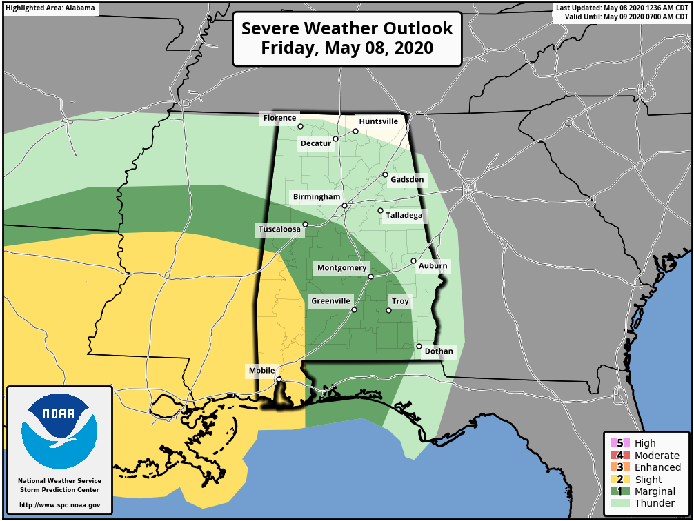
A few storms over the southwest part of Alabama later today could produce hail and gusty winds, just a low-end tornado threat there. Rain amounts should be under 1/2 inch, and there is no risk of flooding. Pressure gradient winds (not related to thunderstorms) will pick up later today after the front passes… northwest winds this afternoon will average 15-25 mph with potential for higher gusts. A wind advisory is in effect for much of Central Alabama. Rain will end from west to east this evening as the front moves on to the east.
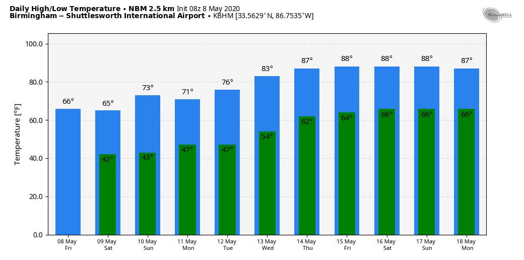
THE ALABAMA WEEKEND: We expect sunshine in full supply tomorrow and Sunday with a very dry airmass in place, but mornings will be cold. Look for lows in the 37-43 degree range; some scattered light frost is possible early Sunday morning across the colder valleys and protected areas… this is when the wind will be light. The high tomorrow will be in the mid-60s, followed by mid-70s Sunday.
NEXT WEEK: The week looks dry with a warming trend. The high will be close to 70 Monday, followed by mid-70s Tuesday. Then, we rise into the low-80s Wednesday, and mid-80s Thursday and Friday. See the Weather Xtreme video for maps, graphics, and more details.
Still no sign of any major severe weather or excessive rain events for the state for the next seven to ten days.
ON THIS DATE IN 1979: Widespread damage occurred in the Tampa Bay area. The 19 tornadoes reported are the most in one day in Florida history. Three people drowned in Pinellas County where flooding was most severe. Rainfall amounts of 18 inches in 24 hours were reported with 12.73 inches falling at Tampa, FL; with 7.84 inches of that in just six hours. Worst hit was the Polk County community of Auburndale where a tornado made a direct hit on the Auburndale School. Flying debris hurt only eight students.
ON THIS DATE IN 2003: This was the second of three consecutive days with strong to violent tornadoes around Oklahoma City. A violent F4 tornado that affected Moore, Oklahoma City, Midwest City and Choctaw took on a path very similar to the 5/3/1999 devastating tornado. This particular storm back in 2003 affected areas from Newcastle and Moore to Del City and Choctaw. Although over 130 people were injured, there were no fatalities.
BEACH FORECAST: Click here to see the AlabamaWx Beach Forecast Center page.
WEATHER BRAINS: Don’t forget you can listen to our weekly 90 minute show anytime on your favorite podcast app. This is the show all about weather featuring many familiar voices, including our meteorologists here at ABC 33/40.
CONNECT: You can find me on all of the major social networks…
Facebook
Twitter
Instagram
Pinterest
Snapchat: spannwx
Look for the next Weather Xtreme video here by 4:00 this afternoon… enjoy the day!
Category: Alabama's Weather, ALL POSTS, Weather Xtreme Videos
About the Author (Author Profile)
James Spann is one of the most recognized and trusted television meteorologists in the industry. He holds the AMS CCM designation and television seals from the AMS and NWA. He is a past winner of the Broadcast Meteorologist of the Year from both professional organizations.Subscribe
If you enjoyed this article, subscribe to receive more just like it.


