Summer-Like Warmth Arrives Later This Week
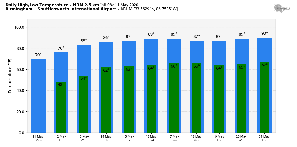
ANOTHER BEAUTIFUL DAY AHEAD: A cold front passed through Alabama in dry fashion last night, and we are forecasting another beautiful day across the Deep South. With ample sunshine, expect a high close to 70 degrees this afternoon with low humidity levels. The average high for May 11 at Birmingham is 80.
REST OF THE WEEK: THe upper trough over the eastern U.S. will be replaced by an upper ridge, and accordingly temperatures will begin to warm up. The high tomorrow will be in the mid-70s, followed by low-80s Wednesday. Then, mid-80s are likely Thursday and Friday as the warm-up continues. Most of Alabama will be dry through the week, although a few isolated showers can’t be totally ruled out near the Mississippi and Tennessee border late in the week.
THE ALABAMA WEEKEND: Not much change; a very quiet pattern continues with summer-like temperatures. Highs Saturday and Sunday will be in the mid to upper 80s with a partly sunny sky. The best chance of rain will stay west and north of Alabama, although a few isolated showers could pop up over the far western and northern counties of our state.
NEXT WEEK: The very warm, dry pattern will likely continue with an upper ridge over the region. Highs will remain well up in the 80s with little if any chance of really meaningful rain for a decent part of the week. No sign of any heavy rain or severe weather issues here over the next seven to ten days. See the Weather Xtreme video for maps, graphics, and more details.
YESTERDAY MORNING: Winter’s last gasp brought some very cold readings to our state. Lows for May 10 included…
Black Creek (near Gadsden) 31 Vic Bell, reports: “My first May freeze here in 20 years of record-keeping, I’ve had frost as late as May 22”
Little River Falls 31
Heflin 35
Haleyville 35
Gadsden 35
Pell City 36
Hueytown 36
Weaver 36
Sylacauga 37
Coker 38
Anniston 39 (new record low for May 10; old record was 40 in 1966)
Huntsville 39
Alexander City 39
Selma 39
Birmingham 40 (within two degrees of the May 10 record low, 38 set in 1966)
Tuscaloosa 42 (within one degree of the May 10 record low, 41 last set in 1984 and 1966)
Marion 40
Northport 42
Muscle Shoals 43
Montgomery 44 (within one degree of the May 10 record low, 43 last set in 1906)
Troy 44
Mobile 55
ON THIS DATE IN 1953: A terrifying F5 tornado rips through downtown Waco, Texas, killing 114 people and injuring nearly 600 more. More than 850 homes, 600 businesses, and 2,000 cars are destroyed or severely damaged. Losses have been estimated at $41 million. The tornado is the deadliest in Texas history and the tenth deadliest in the US.
ON THIS DATE IN 1970: A devastating tornado struck Lubbock, Texas. The tornado, actually the second of two that struck the city that night, touched down around 9:30 in the evening southwest of downtown and moved northeast, causing terrible damage along its path, until it lifted around the Lubbock Municipal Airport shortly after 10:00 pm. The tornado killed 26 people and injured more than 1500 along its 8.5-mile track while covering about 15 square miles of Lubbock.
BEACH FORECAST: Click here to see the AlabamaWx Beach Forecast Center page.
WEATHER BRAINS: Don’t forget you can listen to our weekly 90-minute show anytime on your favorite podcast app. This is the show all about weather featuring many familiar voices, including our meteorologists here at ABC 33/40.
CONNECT: You can find me on all of the major social networks…
Facebook
Twitter
Instagram
Pinterest
Snapchat: spannwx
Look for the next Weather Xtreme video here by 4:00 this afternoon… enjoy the day!
Category: Alabama's Weather, ALL POSTS, Weather Xtreme Videos
About the Author (Author Profile)
James Spann is one of the most recognized and trusted television meteorologists in the industry. He holds the AMS CCM designation and television seals from the AMS and NWA. He is a past winner of the Broadcast Meteorologist of the Year from both professional organizations.Subscribe
If you enjoyed this article, subscribe to receive more just like it.


