Very Humid Air In Place; Scattered Showers/Storms Later Today
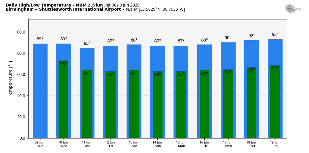
MUGGY MORNING: Temperatures are in the 70s, dewpoints are in the 70s across Alabama early this morning as a very moist, tropical airmass remains in place. The radar is quiet as the day begins, but scattered showers and thunderstorms will form again this afternoon and tonight. Odds of any one spot getting wet today are around 60 percent, and the high will be in the mid to upper 80s with a mix of sun and clouds. A strong storm is certainly possible this afternoon, but organized severe weather is not expected.
JUNE FRONT ON THE WAY: A rare summer “cold” front will push into Alabama tomorrow, setting the stage for more showers and thunderstorms. Some of the storms could be strong, possibly severe… the main threat comes from strong gusty winds. SPC has a decent part of the state in a “marginal risk” (level 1/5).

Following the front, unusually dry air for June moves into the state Wednesday night, and we expect sunshine in full supply Thursday and Friday with lower humidity and cooler nights. Highs will be in the 80s, with lows well down in the 60s. Cooler spots will likely see early morning temperatures in the mid to upper 50s.
THE ALABAMA WEEKEND: Most of the state will remain shower-free Saturday and Sunday. The sky will be mostly sunny both days with highs in the 80s and lows in the 60s. Showers will be confined, most likely, to the southeast corner of the state.
NEXT WEEK: A quiet weather pattern continues. Moist levels will slowly rise, and we could see a few isolated showers by mid-week, but nothing to suggest any widespread rain. Highs will be mostly in the upper 80s through the week… See the Weather Xtreme video for maps, graphics, and more details.
TROPICS: A low pressure area east of Bermuda is not expected to become a tropical storm, and the rest of the Atlantic basin is quiet.
ON THIS DATE IN 1966: Hurricane Alma made landfall over the eastern Florida panhandle near Apalachee Bay with winds of 90 mph. This marked the earliest United States hurricane landfall since a hurricane in May and June of 1825. Damage in the lower Florida Keys was estimated at around $300,000. In southwestern Florida, the hurricane heavily damaged the mango crop. High rainfall totals occurred across the state, peaking at 9.94″ in Dania Beach near Miami. There were eight tornadoes or funnel clouds in the state, including one in Dade County that damaged a home. Along the west coast of Pinellas County, the storm damaged the grapefruit crop. High winds, including a gust of 93 mph, caused power outages in the Tampa Bay Area
BEACH FORECAST: Click here to see the AlabamaWx Beach Forecast Center page.
WEATHER BRAINS: Don’t forget you can listen to our weekly 90 minute show anytime on your favorite podcast app. This is the show all about weather featuring many familiar voices, including our meteorologists here at ABC 33/40.
CONNECT: You can find me on all of the major social networks…
Facebook
Twitter
Instagram
Pinterest
Snapchat: spannwx
Look for the next Weather Xtreme video here by 4:00 this afternoon… enjoy the day!
Category: Alabama's Weather, ALL POSTS, Weather Xtreme Videos
About the Author (Author Profile)
James Spann is one of the most recognized and trusted television meteorologists in the industry. He holds the AMS CCM designation and television seals from the AMS and NWA. He is a past winner of the Broadcast Meteorologist of the Year from both professional organizations.Subscribe
If you enjoyed this article, subscribe to receive more just like it.


