

Dry Pattern For Alabama Through Next Week
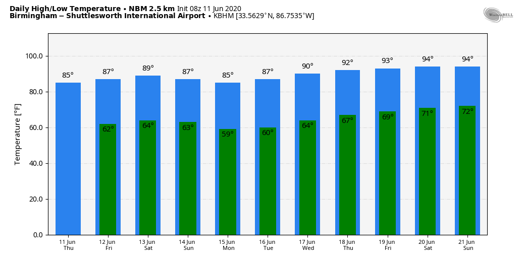
LOWER HUMIDITY, COOLER NIGHTS: As advertised, a much drier airmass now covers Alabama, and that will set the stage for an extended period of rain-free weather. Today will be sunny, humidity levels will be lower, and the high will be in the mid-80s. The average high for Birmingham on June 11 is 87.
TOMORROW THROUGH THE WEEKEND: Look for mostly sunny warm days and fair pleasant nights through Sunday. A reinforcing surge of dry air arrives over the weekend, which will keep us dry through most of next week. Highs will be generally in the mid-80s, with lows well down in the 60s. Cooler spots will see early morning temperatures in the 50s.
NEXT WEEK: Most of North/Central Alabama will enjoy lows in the 50s Monday and Tuesday; there is even a chance a few spots could visit the upper 40s over the cooler pockets. Highs will be in the low-80s Monday, mid-80s Tuesday, and close to 90 Wednesday. Low-90s are likely by Thursday and Friday with humidity levels creeping back up. There is no threat of significant rain through the week; an unusually dry pattern for the month of June. See the Weather Xtreme video for maps, graphics, and more details.
TROPICS: A well-defined tropical wave is located about 425 miles east of the Windward Islands, producing disorganized showers and thunderstorms. Although further development is not expected due to dry air and adverse upper-level winds, some areas of heavy rain and gusty winds are possible across portions of the Windward Islands through tonight while the wave moves westward at 15 to 20 mph. The rest of the Atlantic basin is quiet, and tropical storm formation is not expected through the weekend.
RAIN UPDATE: Here are rain totals so far in 2020, and the departure from average:
Birmingham 46.17″ (+20.77″)
Anniston 43.24″ (+24.25″)
Tuscaloosa 42.06″ (+17.16″)
Muscle Shoals 41.97″ (+16.83″)
Huntsville 41.37″ (+15.58″)
Montgomery 34.55″ (+9.95″)
Mobile 28.16″ (-0.52″)
ON THIS DATE IN 1990: One of the most expensive hailstorms in U.S. history occurred as $625 million of damage was caused along the Colorado Front Range from Colorado Springs to Estes Park. Golf to baseball-sized hail fell along with heavy rain. 60 people were injured in the storm.
BEACH FORECAST: Click here to see the AlabamaWx Beach Forecast Center page.
WEATHER BRAINS: Don’t forget you can listen to our weekly 90 minute show anytime on your favorite podcast app. This is the show all about weather featuring many familiar voices, including our meteorologists here at ABC 33/40.
CONNECT: You can find me on all of the major social networks…
Facebook
Twitter
Instagram
Pinterest
Snapchat: spannwx
Look for the next Weather Xtreme video here by 4:00 this afternoon… enjoy the day!
Category: Alabama's Weather, ALL POSTS, Weather Xtreme Videos
About the Author (Author Profile)
James Spann is one of the most recognized and trusted television meteorologists in the industry. He holds the AMS CCM designation and television seals from the AMS and NWA. He is a past winner of the Broadcast Meteorologist of the Year from both professional organizations.Subscribe
If you enjoyed this article, subscribe to receive more just like it.


