Showers/Storms Becoming More Numerous Through Mid-Week
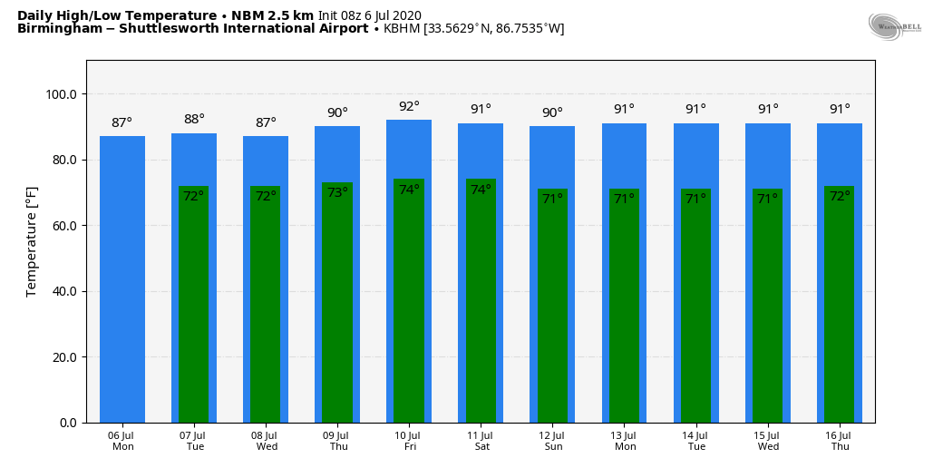
UNSETTLED WEATHER THROUGH WEDNESDAY: Moisture levels will rise across Alabama today, and with a weak upper low moving into the state, we expect scattered to numerous showers and thunderstorms by afternoon. It still won’t rain everywhere, but most communities should see a decent shower by the evening hours. Otherwise, the day will be warm and humid with a mix of sun and clouds along with a high in the mid 80s. The average high today at Birmingham is 91.
Look for a mostly cloudy sky tomorrow and Wednesday with occasional showers and a few thunderstorms as the unsettled pattern continues. While the best chance of rain will come during the afternoon and evening hours, a few late night or morning showers can’t be ruled out… highs will remain in the mid 80s.
THURSDAY/FRIDAY: The upper low will move away from the region, and showers and thunderstorms will become more scattered over the latter half of the week. The sky will be partly sunny, and afternoon highs will rise into the 88-92 degree range.
THE ALABAMA WEEKEND: For the moment, global models are showing a pretty dry look for Alabama; we expect a good supply of sunshine Saturday and Sunday with only isolated showers… highs will be mostly in the low 90s, right at seasonal averages.
NEXT WEEK: Moisture levels tick up again, and we will mention the typical risk of “scattered, mostly afternoon and evening showers and thunderstorms” each day. Otherwise, partly sunny days with afternoon highs remaining generally in the low 90s. See the Weather Xtreme video for maps, graphics, and more details.
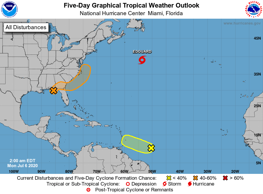
TROPICS HEATING UP A BIT: Tropical Storm Edouard has formed in the Atlantic, northeast of Bermuda, with sustained winds of 40 mph. It will remain far from land, and should become post-tropical later today.
A strong tropical wave, centered about 650 miles east of the Windward Islands, is producing disorganized showers and thunderstorms. Some slight development of this system is possible today before environmental conditions become hostile for development on Tuesday. The wave is forecast to move through the Lesser Antilles tomorrow and could produce locally heavy rainfall as well as gusty winds on some of those islands.
And, there is a well defined low this morning in North Florida between Tallahassee and Marianna… this is moving northeast and will remain over land today and tomorrow. This system is expected to evolve into a larger low pressure system and move northeastward, possibly emerging offshore of the Carolinas later this week where environmental conditions are expected to be more conducive for development later this week.
ON THIS DATE IN 1928: A seven-inch hailstone weighing 1.5 pounds fell in Potter Nebraska. With a circumference of 17 inches, this appeared to be the largest hailstone in the world at that time.
BEACH FORECAST: Click here to see the AlabamaWx Beach Forecast Center page.
WEATHER BRAINS: Don’t forget you can listen to our weekly 90 minute show anytime on your favorite podcast app. This is the show all about weather featuring many familiar voices, including our meteorologists here at ABC 33/40.
CONNECT: You can find me on all of the major social networks…
Facebook
Twitter
Instagram
Pinterest
Snapchat: spannwx
Look for the next Weather Xtreme video here by 4:00 this afternoon… enjoy the day!
Category: Alabama's Weather, ALL POSTS, Weather Xtreme Videos
About the Author (Author Profile)
James Spann is one of the most recognized and trusted television meteorologists in the industry. He holds the AMS CCM designation and television seals from the AMS and NWA. He is a past winner of the Broadcast Meteorologist of the Year from both professional organizations.Subscribe
If you enjoyed this article, subscribe to receive more just like it.


