Very Humid; Numerous Showers/Storms Today
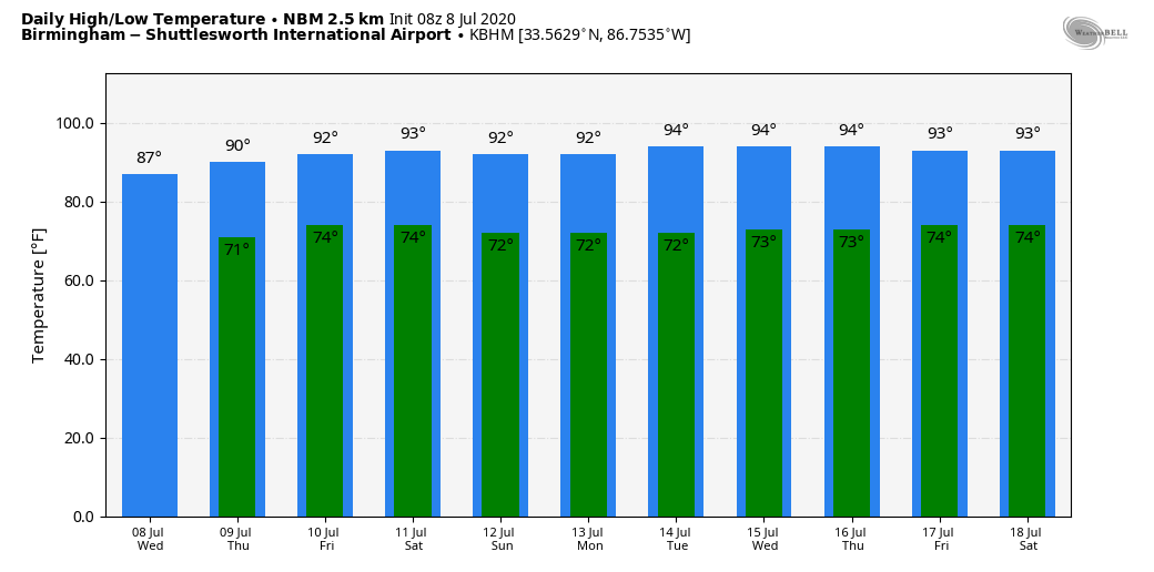
AN OCEAN OF HUMIDITY: Very moist, tropical air will remain over the Deep South today, and we expect scattered to numerous showers and thunderstorms. In fact, showers have already formed early this morning across parts of North/Central Alabama. And, like recent days, the showers will be very efficient rain producers. We will have more clouds than sun, and the high today will be in the mid 80s for most communities. The average high for July 8 at Birmingham is 91.
TOMORROW/FRIDAY: Scattered showers and storms will remain possible, although they could be a little fewer in number, and mostly during the afternoon and evening hours. Otherwise, expect a mix of sun and clouds both days with a high around 90 tomorrow, and in the low 90s Friday.
THE ALABAMA WEEKEND: Looks like this will be the hottest weekend so far this summer for most places; highs will be in the 91-95 degree range with a partly to mostly sunny sky both days. Afternoon thunderstorms should be fairly isolated, as the air will be drier. We do note we will be on the eastern periphery of a big heat dome centered west of our state; sometimes organized thunderstorm areas form over Missouri and Arkansas, and roll down into Alabama in the northwest flow aloft. No way of knowing in advance exactly when, or if they form… just something to watch.
NEXT WEEK: Hot, humid weather continues through the week. Partly sunny days, highs in the low to mid 90s, and the daily risk of random, scattered, mostly afternoon and evening showers and thunderstorms. Classic mid-summer weather… See the Weather Xtreme video for maps, graphics, and more details.
TROPICS: An area of low pressure centered inland over South Carolina continues to produce a large area of disorganized showers and heavy rain over portions of the southeastern United States. The low is expected to move east-northeastward toward the coast later today and then turn northeastward near or just offshore of the Carolinas and the mid-Atlantic states Thursday and Friday, where a tropical or subtropical cyclone could form if the low moves over water (the name will be “Fay”). Regardless of development, the low is expected to to produce locally heavy rainfall that could cause flash flooding across portions of the southeastern and mid-Atlantic U.S. during the next few days.
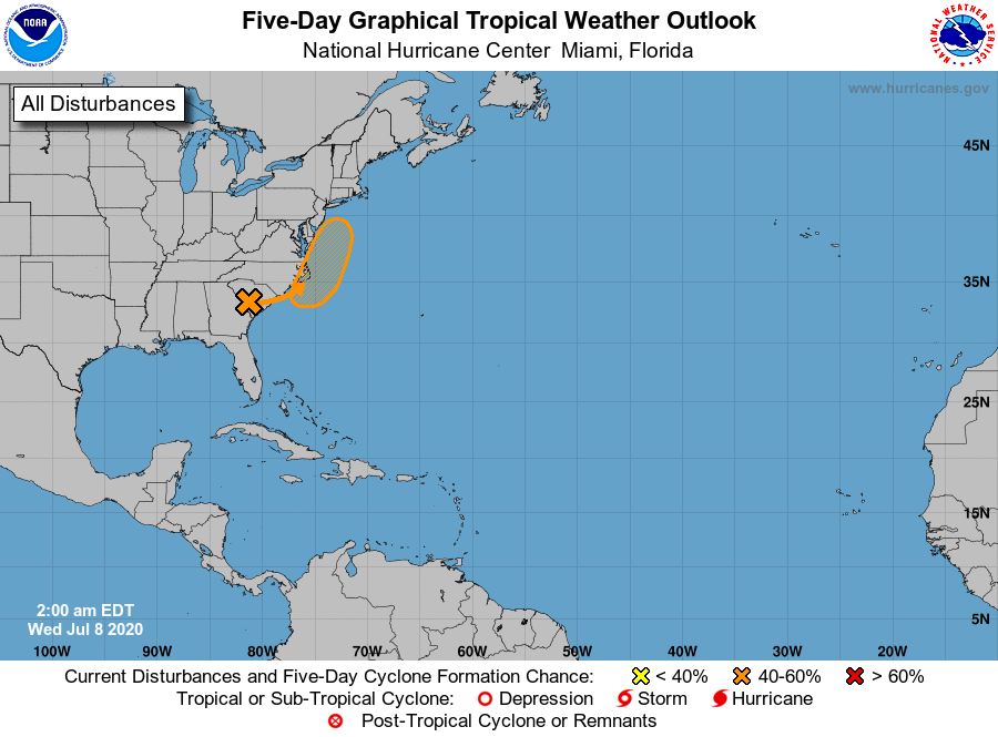
Otherwise, the Atlantic basin, including the Gulf of Mexico, is quiet.
ON THIS DATE IN 2003: What may be the world’s highest dew point temperature was recorded at Dhahran, Saudi Arabia, in the Persian Gulf. A dew point of 95 degrees was recorded at 3 PM while the air temperature was 108 degrees. The apparent temperature at that time would have been 172 degrees.
BEACH FORECAST: Click here to see the AlabamaWx Beach Forecast Center page.
WEATHER BRAINS: Don’t forget you can listen to our weekly 90 minute show anytime on your favorite podcast app. This is the show all about weather featuring many familiar voices, including our meteorologists here at ABC 33/40.
CONNECT: You can find me on all of the major social networks…
Facebook
Twitter
Instagram
Pinterest
Snapchat: spannwx
Look for the next Weather Xtreme video here by 4:00 this afternoon… enjoy the day!
Category: Alabama's Weather, ALL POSTS, Weather Xtreme Videos
About the Author (Author Profile)
James Spann is one of the most recognized and trusted television meteorologists in the industry. He holds the AMS CCM designation and television seals from the AMS and NWA. He is a past winner of the Broadcast Meteorologist of the Year from both professional organizations.Subscribe
If you enjoyed this article, subscribe to receive more just like it.


