

Hanna Headed For Texas; Scattered Storms For Alabama Later Today
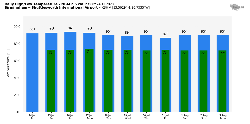
MUGGY SUMMER DAYS: Humid weather will continue across Alabama through the weekend; look for a mix of sun and clouds each day with the typical round of “scattered, mostly afternoon and evening showers and thunderstorms” on a daily basis. Odds of any one spot getting wet each afternoon through Sunday will be around 30 percent, and highs will be close to 90 degrees. The average high for Birmingham on July 24 is 91. Very routine summer weather.
NEXT WEEK: A broad upper trough will develop over the region, and with deep moisture in place we are looking at a fairly unsettled pattern through the week. The sky will be occasionally cloudy with scattered to numerous showers and thunderstorms each day. Highs will drop into the upper 80s on most days due to the clouds and showers. See the Weather Xtreme video for maps, graphics, and more details.
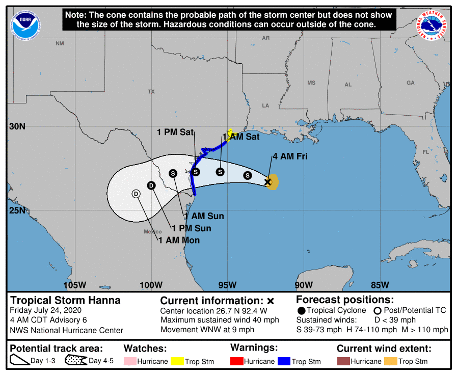
TROPICAL STORM HANNA: The tropical system in the Gulf of Mexico looks well organized this morning as clouds tops cool and convection increases. Hanna is expected to be an upper end tropical storm tomorrow as it moves into the Texas coast south of Corpus Christi. The main threat for South Texas is heavy rain and flooding; amounts of 4-8 inches are likely with locally heavier amounts. On the Central Gulf Coast (Gulf Shores to Panama City Beach), the rip current danger will remain high today, but seas will be calmer over the weekend as Hanna moves inland.
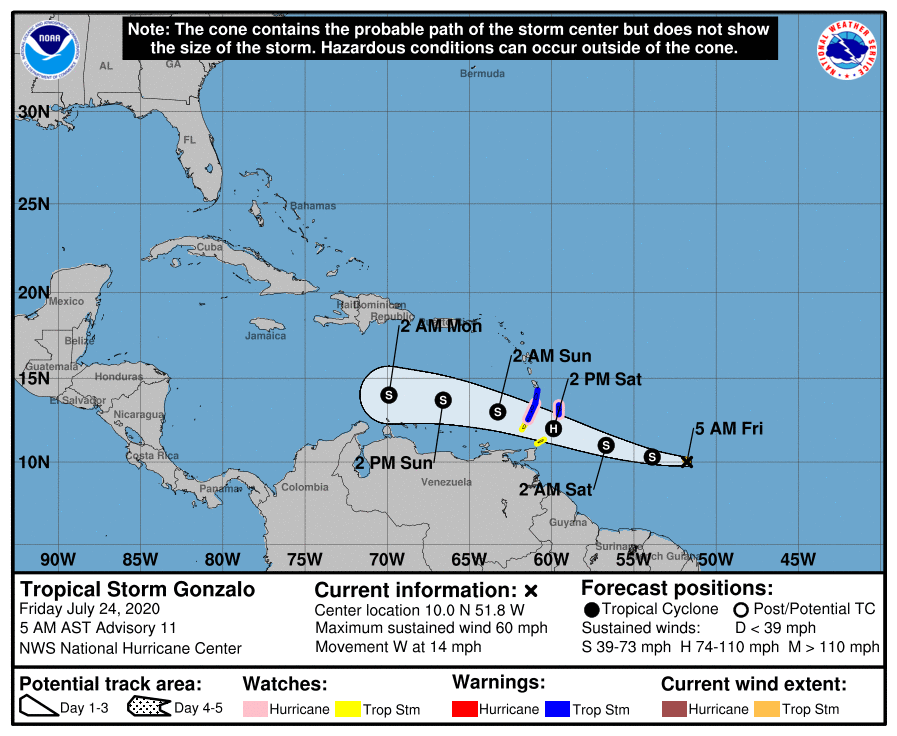
TROPICAL STORM GONZALO: This small, compact storm will move across the Windward Islands late tomorrow, perhaps as a minimal hurricane. Then, the NHC forecast shows the system dissipating over the Caribbean by Monday morning due to harsh environmental conditions well before reaching the Gulf of Mexico.
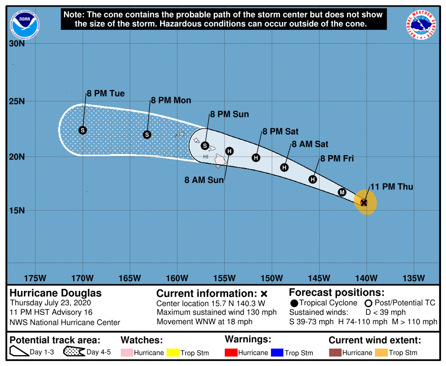
HURRICANE DOUGLAS: This major hurricane in the Pacific is packing sustained winds of 130 mph; it will weaken as it moves over the Hawaiian Islands over the weekend, but will still produce strong winds and heavy rain.
We also note there is a well organized tropical wave that has emerged off the coast of Africa; NHC gives it a 30 percent chance of becoming a tropical depression or storm within five days as it moves westward across the open Atlantic. Just something to watch for now.
ON THIS DATE IN 1952: The temperature at Louisville, Georgia soared to 112 degrees to establish a state record. The temperature also hit 112 degrees in Greenville, Georgia on August 20, 1983.
BEACH FORECAST: Click here to see the AlabamaWx Beach Forecast Center page.
WEATHER BRAINS: Don’t forget you can listen to our weekly 90 minute show anytime on your favorite podcast app. This is the show all about weather featuring many familiar voices, including our meteorologists here at ABC 33/40.
CONNECT: You can find me on all of the major social networks…
Facebook
Twitter
Instagram
Pinterest
Snapchat: spannwx
Look for the next Weather Xtreme video here by 4:00 this afternoon… enjoy the day!
Category: Alabama's Weather, ALL POSTS, Weather Xtreme Videos
About the Author (Author Profile)
James Spann is one of the most recognized and trusted television meteorologists in the industry. He holds the AMS CCM designation and television seals from the AMS and NWA. He is a past winner of the Broadcast Meteorologist of the Year from both professional organizations.Subscribe
If you enjoyed this article, subscribe to receive more just like it.


