Scattered Showers/Storms Increasing In Number
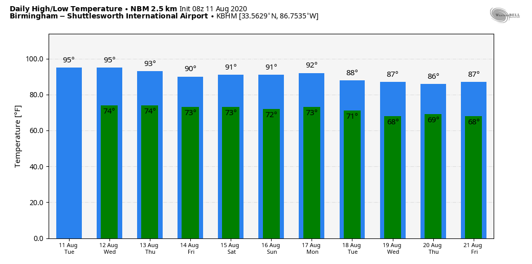
RADAR CHECK: We have a batch of early morning thunderstorms on radar today over the northern third of the state, slowly pushing southward. They aren’t severe, but some spots are getting heavy rain and a good bit of lightning for an early wake up call. These storms will diminish later this morning, but a few more showers or storms could redevelop this afternoon in the moist environment across the state. Otherwise, expect a mix of sun and clouds today with highs in the low 90s, right at seasonal averages for mid-August.
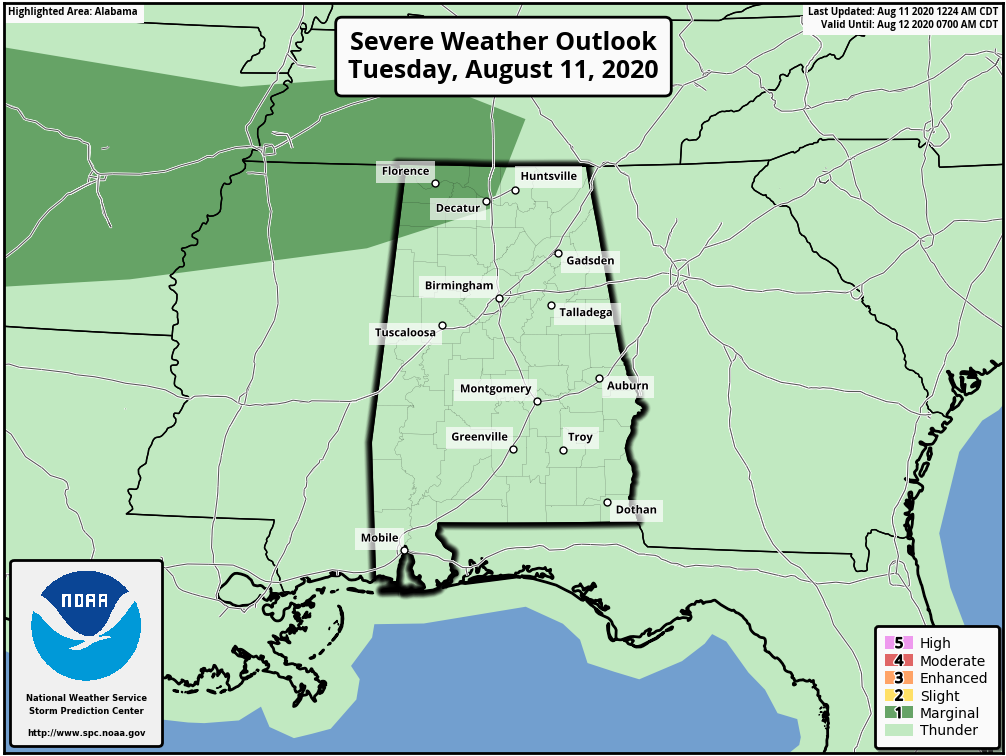
We do note SPC has a low end “marginal risk” (level 1/5) defined for Northwest Alabama later today and tonight; a few storms there could produce strong winds.
REST OF THE WEEK: Look for scattered to numerous showers and thunderstorms on a daily basis tomorrow through Friday; most of them (but not necessarily all) will come from about 1:00 until 11:00 p.m. Heat levels will slowly back down; look for a high in the low 90s today and tomorrow; and close to 90 Thursday and Friday. Rain distribution will be very uneven due to the scattered nature of the showers and storms, but some spots could see over one inch of rain from now through Friday.
THE ALABAMA WEEKEND: We will still mention some risk of scattered showers Saturday, but global models are suggesting drier air will begin to enter the state, making them fewer in number. And, at this point, Sunday looks mostly dry with a good supply of sunshine and only a small risk of a shower. Highs over the weekend will be at or just over 90 degrees for most communities.
NEXT WEEK: The weather looks fairly quiet early in the week with only isolated showers, and we expect a trend toward lower heat levels as an upper trough forms over the eastern U.S. Highs could drop into the 80s over the latter half of the week, with lows in the 60s. See the Weather Xtreme video for maps, graphics, and more details.
TROPICS: Thunderstorm activity associated with a large low pressure system located more than 800 miles west-southwest of the Cabo Verde Islands has increased and become a little better organized over the past several hours. Environmental conditions are expected to be conducive for development to occur, and a tropical depression is likely to form during the next day or so while the disturbance moves westward to west-northwestward at around 15 mph across the tropical Atlantic. Conditions are forecast to become less conducive for development by the end of the week.
If a system does form and survive, most likely it will gain latitude and recurve into the open Atlantic east of the U.S. The rest of the Atlantic basin, including the Gulf of Mexico, is quiet.
HEAT PARADE: Yesterday was one of the hottest days so far this summer for Alabama. Highs included…
Muscle Shoals 100
Huntsville 98
Montgomery 98
Birmingham 95
Mobile 93
ON THIS DATE IN 1999: An F2 tornado touched down in the metropolitan area of Salt Lake City. The tornado lasted ten minutes and killed one person, injured more than 80 people, and caused more than $170 million in damages. It was the most destructive tornado in Utah’s history and awakened the entire state’s population to the fact that the Beehive State does experience tornadoes
BEACH FORECAST: Click here to see the AlabamaWx Beach Forecast Center page.
WEATHER BRAINS: Don’t forget you can listen to our weekly 90 minute show anytime on your favorite podcast app. This is the show all about weather featuring many familiar voices, including our meteorologists here at ABC 33/40.
CONNECT: You can find me on all of the major social networks…
Facebook
Twitter
Instagram
Pinterest
Snapchat: spannwx
Look for the next Weather Xtreme video here by 4:00 this afternoon. Enjoy the day!
Category: Alabama's Weather, ALL POSTS, Weather Xtreme Videos
About the Author (Author Profile)
James Spann is one of the most recognized and trusted television meteorologists in the industry. He holds the AMS CCM designation and television seals from the AMS and NWA. He is a past winner of the Broadcast Meteorologist of the Year from both professional organizations.Subscribe
If you enjoyed this article, subscribe to receive more just like it.


