A Brief Tornado or Two Remains Possible For Several More Hours
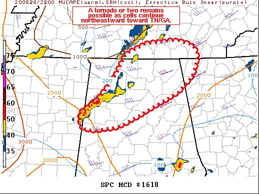
SUMMARY…The threat for a few tornadoes persists across northern
Alabama, and may eventually develop northeastward toward Chattanooga
before weakening this evening.
DISCUSSION…Several supercells are currently ongoing over northern
AL, with persistent midlevel rotation. The HTX VWP shows sufficient
0-1 SRH for a tornado threat at around 150 m2/s2, and surface
observations continue to show modest pressure falls downstream.
The air mass also remains very moist with GPS PWAT values over 2.00″
over northeast AL/northwest GA. While at least some diurnal decrease
is possible after 01Z, conditions will remain favorable for
tornadoes for a few hours, perhaps reaching as far northeast as
Chattanooga. If storms remain severe through 01Z, an additional
watch could be considered.
Category: Alabama's Weather, ALL POSTS, Severe Weather
About the Author (Author Profile)
Scott Martin is an operational meteorologist, professional graphic artist, musician, husband, and father. Not only is Scott a member of the National Weather Association, but he is also the Central Alabama Chapter of the NWA president. Scott is also the co-founder of Racecast Weather, which provides forecasts for many racing series across the USA. He also supplies forecasts for the BassMaster Elite Series events including the BassMaster Classic.Subscribe
If you enjoyed this article, subscribe to receive more just like it.


