Hotter/Drier Weather Ahead For Alabama
RADAR CHECK: Scattered showers and thunderstorms are most active over the northern and eastern counties of Alabama this afternoon; like recent days the stronger storms are producing heavy rain, gusty winds, and frequent lightning. Away from the showers, the sky is partly sunny with temperatures not far from 90 degrees.
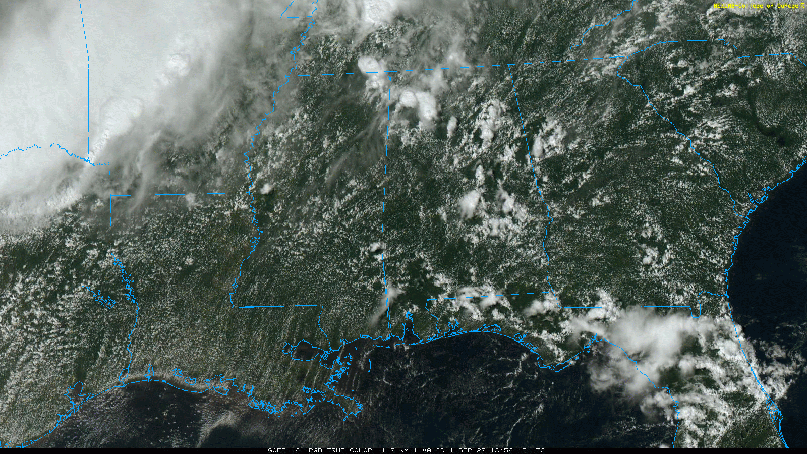
Showers will end tonight after sunset.
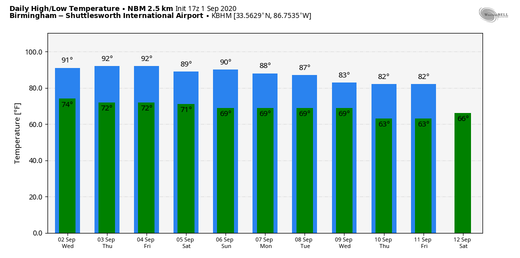
TOMORROW THROUGH FRIDAY: The upper ridge over the region will grow stronger, and our weather will trend hotter and drier. We expect mostly sunny days, fair nights, and only very isolated showers each afternoon. Afternoon highs will be in the 90-94 degree range; about five degrees above average for early September in Alabama.
LABOR DAY WEEKEND: Heat levels will come down; we expect highs in the upper 80s Saturday through Monday. The weather stays mostly dry Saturday and Sunday with a good supply of sunshine and only isolated showers. Showers and storms become more numerous Monday as a cold front approaches, but it still won’t rain all day.
NEXT WEEK: We are forecasting scattered to numerous showers and thunderstorms Tuesday and Wednesday, followed by noticeably cooler and drier air Thursday and Friday. Highs will drop into the low 80s by the end of the week, and many communities across North Alabama should see lows in the 50s. See the Weather Xtreme video for maps, graphics, and more details.
FOOTBALL WEATHER: UAB kicks off their season Thursday night against Central Arkansas (7p CT at Legion Field)… it will be a great night for football. A clear sky; 88 degrees at kickoff, 82 by the final whistle. Light SW wind.
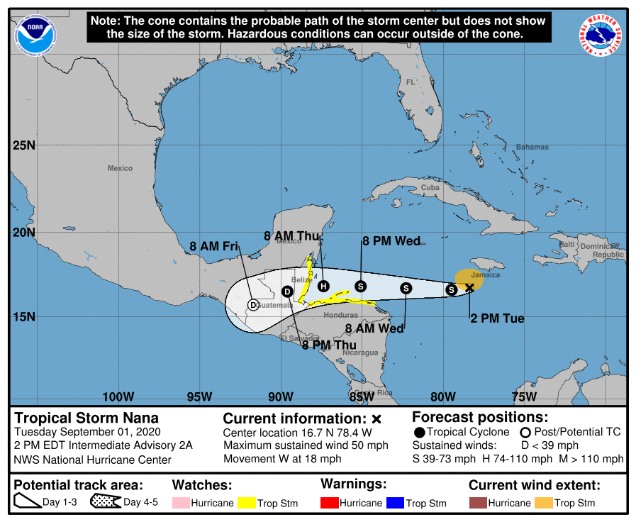
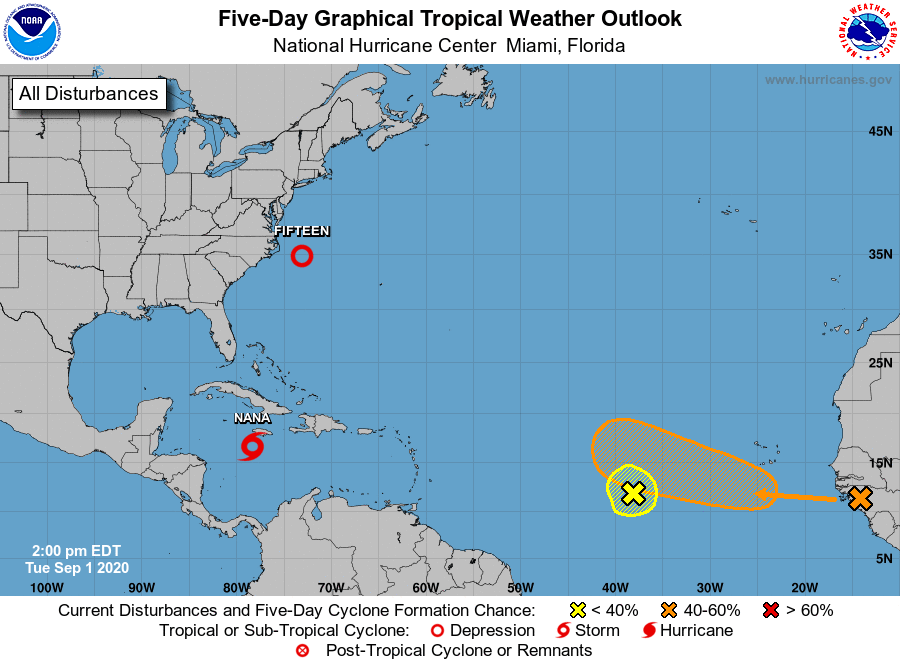
TROPICS: Tropical Storm Nana has formed in the Caribbean southwest of Jamaica; it will likely make landfall on the coast of Belize Thursday as a hurricane. It will remain far to the south of the Gulf of Mexico.
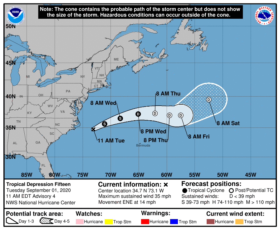
And, Tropical Depression 15 is in the. Atlantic well east of the North Carolina coast. It could briefly become a tropical storm (it will get the name “Omar”) before it weakens again and dissipates. It another weak, junk system with no impact on land.
Elsewhere, a small area of low pressure has formed about midway between the Windward Islands and west Africa. Upper-level winds are marginally conducive for some slow development this week as the system meanders in the central tropical Atlantic Ocean. And, another tropical wave is expected to emerge off the coast of Africa in about a day and merge with a disturbance centered about 200 miles southeast of the Cabo Verde Islands in a couple of days. Gradual development of this system is then possible, and this system could become a tropical depression by this weekend while it moves slowly westward over the eastern tropical Atlantic Ocean. Way too early too know if these will impact the U.S. or any land mass.
The Gulf of Mexico will remain quiet through the Labor Day weekend; we expect routine weather on the Central Gulf Coast (Gulf Shores to Panama City Beach) with the usual mix of sun and scattered thunderstorms.
ON THIS DATE IN 2019: Dorian made landfall on Abaco Island (and then Grand Bahama) as a category 5 with 185 mph winds and a storm surge of 20 feet, making it the strongest hurricane in recorded history to hit the Bahamas. At least 70,000 people were left homeless.
ON THIS DATE IN 1974: Lt. Judy Neuffer became the first female to fly a Hurricane Hunter aircraft through the eye of a hurricane (Carmen). Carmen moved ashore on the Yucatán Peninsula as a category four hurricane, where, despite striking a sparsely populated region, it caused significant crop damage and killed several people. Landfall then came later on the U.S. coast over southern Louisiana, west of New Orleans. Many Mississippi citizens, having experienced the destruction of Hurricane Camille just five years earlier, quickly left their coastal homes.
BEACH FORECAST: Click here to see the AlabamaWx Beach Forecast Center page.
WEATHER BRAINS: Don’t forget you can listen to our weekly 90 minute show anytime on your favorite podcast app. This is the show all about weather featuring many familiar voices, including our meteorologists here at ABC 33/40.
CONNECT: You can find me on all of the major social networks…
Facebook
Twitter
Instagram
Pinterest
Snapchat: spannwx
Look for the next Weather Xtreme video here by 7:00 a.m. tomorrow…
Category: Alabama's Weather, ALL POSTS, Weather Xtreme Videos
About the Author (Author Profile)
James Spann is one of the most recognized and trusted television meteorologists in the industry. He holds the AMS CCM designation and television seals from the AMS and NWA. He is a past winner of the Broadcast Meteorologist of the Year from both professional organizations.Subscribe
If you enjoyed this article, subscribe to receive more just like it.


