

Sunny, Pleasant Labor Day For Alabama
DRY AIR REMAINS IN PLACE: Another refreshing morning for Alabama; cooler pockets are down in the 50s again. A few of the cooler spots…
Weaver 59
Cullman 59
Talladega 60
Haleyville 60
Decatur 60
Pell City 61
Scottsboro 61
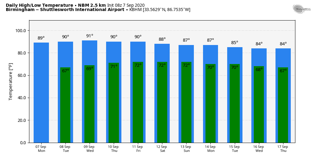
The air is dry, and today will be another sunny day with fairly low humidity. The high this afternoon will be in the upper 80s for most communities; the average high for September 7 at Birmingham is 88.
REST OF THE WEEK: A rather quiet pattern continues. Tomorrow and Wednesday will be generally dry and warm with only a few isolated showers over South Alabama; the high will remain in the upper 80s. Then, we will bring in some risk of scattered showers Thursday and Friday, but nothing widespread. Days will be partly sunny, nights mostly fair.
TO THE WEST: Denver, after experiencing near record heat this weekend, will have their first winter storm of the season beginning late tonight, and continuing during the day tomorrow. Snow amounts there are expected to be in the 3-7 inch range. Record lows are possible by Wednesday morning as they ride the weather roller coaster.
Initially global models (about a week ago) showed a progressive look to the upper trough that is bringing the snow to the Rockies; this was to bring cooler air to the Deep South late this week. But, unfortunately that idea is now off the table as it looks like the ridge will hold here and the cool air will be delayed until later in the month.
THE ALABAMA WEEKEND: For the weekend ahead we expect a mix of sun and clouds Saturday and Sunday, with some risk of scattered showers or thunderstorms both days (no wash-out). Highs will be in the mid to upper 80s.
NEXT WEEK: Not much change; highs will remain in the 80s. Partly sunny days with the usual risk of random, scattered showers and storms on a daily basis, mostly during the afternoon and evening hours. See the Weather Xtreme video for maps, graphics, and more details.
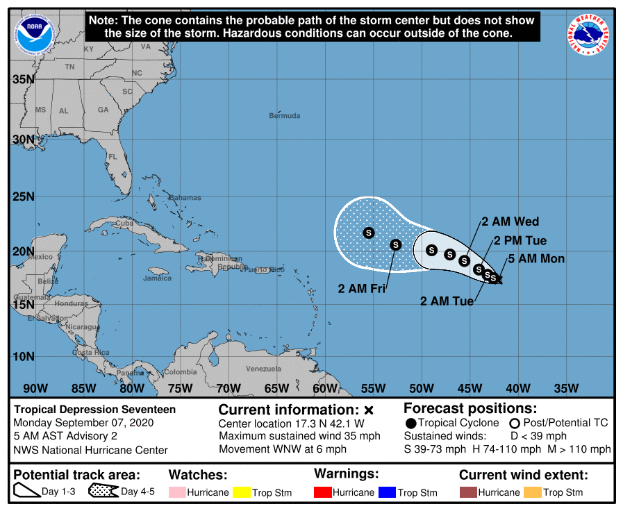
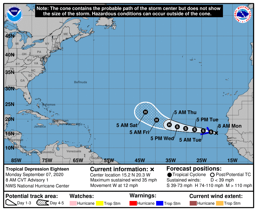
TROPICS: Two new tropical depressions have formed in the eastern Atlantic; TD 17 and TD 18. Both are expected to gain latitude later this week, and global models suggest both systems will turn north and recurve into the open Atlantic well before getting close to the U.S. We will still keep a close eye on both of them, however.
NHC is also monitoring a trough of low pressure located just south-southwest of Bermuda that is producing disorganized cloudiness and showers. Some slow development of this system is possible this week while it moves west-northwestward, in the general direction of the North Carolina coast. For now NHC gives it only a low chance of development during the next five days.
The Gulf of Mexico remains very quiet this week, thankfully.
ON THIS DATE IN 1970: A lightning bolt struck a group of football players at Gibbs High School in St. Petersburg, FL. The lightning killed two people and injuring 22 others. All 38 players and four coaches were knocked off their feet.
ON THIS DATE IN 2004: Hurricane Ivan passed over Grenada, battering several of the Windward Islands. As it entered the Caribbean Sea, Ivan reintensified rapidly and became a Category 5 hurricane, just north of the Windward Netherlands Antilles (Curaçao and Bonaire) and Aruba on September 9, with winds reaching 160 mph. A few days later it would make landfall on the Central Gulf Coast.
BEACH FORECAST: Click here to see the AlabamaWx Beach Forecast Center page.
WEATHER BRAINS: Don’t forget you can listen to our weekly 90 minute show anytime on your favorite podcast app. This is the show all about weather featuring many familiar voices, including our meteorologists here at ABC 33/40.
CONNECT: You can find me on all of the major social networks…
Facebook
Twitter
Instagram
Pinterest
Snapchat: spannwx
We are on a holiday schedule today, so just one video… but I will post fresh forecast notes this afternoon. Enjoy the day!
Category: Alabama's Weather, ALL POSTS, Weather Xtreme Videos
About the Author (Author Profile)
James Spann is one of the most recognized and trusted television meteorologists in the industry. He holds the AMS CCM designation and television seals from the AMS and NWA. He is a past winner of the Broadcast Meteorologist of the Year from both professional organizations.Subscribe
If you enjoyed this article, subscribe to receive more just like it.


