Scattered Showers Return Thursday/Friday
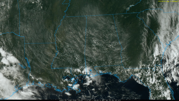
WARM, QUIET DAY: The sky is partly sunny across much of Alabama with temperatures in the upper 80s at mid-afternoon. There are a few isolated showers over the southwest counties of the state, but the day is rain-free across the rest of the state. We also note a little smoke filtering into Alabama in the high altitudes from the western U.S. wildfires.
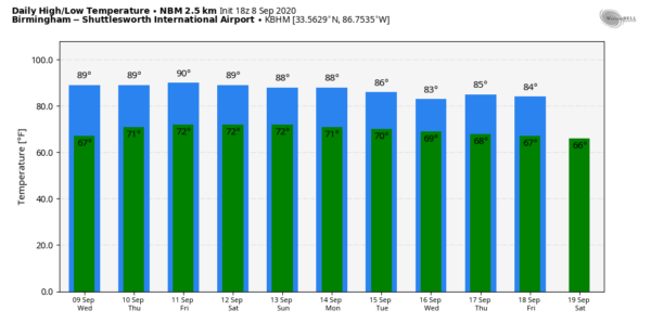
REST OF THE WEEK: We aren’t expecting much change tomorrow, but we will bring in a chance of scattered, mostly afternoon and evening showers and thunderstorms Thursday and Friday statewide as moisture levels rise a bit. Otherwise look for partly sunny days with highs in the 85-90 degree range.
THE ALABAMA WEEKEND: The overall pattern won’t change much. A mix of sun and clouds Saturday and Sunday with the risk of scattered showers and thunderstorms both days. No “wash-out”, but if you have something planned outside be aware a passing shower or storm is possible, especially in the window from noon to midnight. Highs will remain mostly in the mid to upper 80s.
NEXT WEEK: No real change. Partly sunny days with the continued chance of random, scattered, mostly afternoon and evening showers and thunderstorms on a daily basis. See the Weather Xtreme video for maps, graphics, and more details.
TROPICS: As you expect in early September, there is a good bit of action across the Atlantic basin….
INVEST 94L: An area of low pressure is located about 350 miles west-southwest of Bermuda. Shower and thunderstorm activity associated with the low has decreased since this morning, but could increase again tonight. Gradual development of the low is possible during the next two or three days and it could become a tropical depression while it continues to move slowly westward to west-northwestward. Interests along the southeast coast of the U.S. should monitor the progress of this disturbance. It will likely be a rainmaker for parts of the Carolinas later this week one way or another.
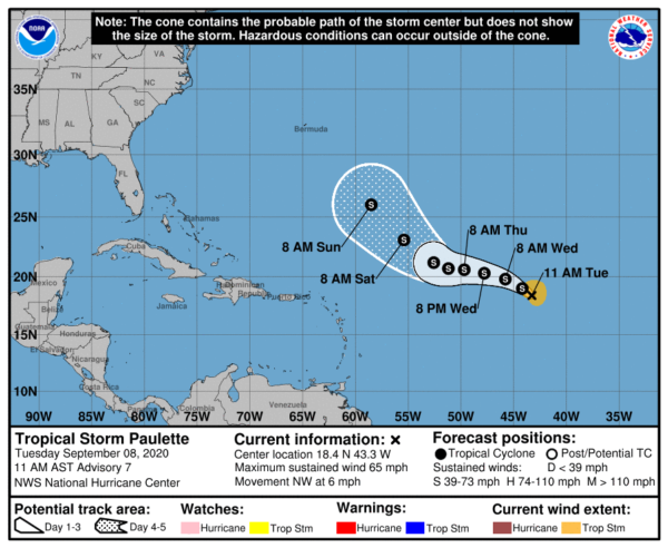
TROPICAL STORM PAULETTE: Now packing sustained winds of 65 mph in the Central Atlantic, Paulette will slowly gain latitude later this week, and is expected to be in a position between Bermuda and the Leeward Islands Sunday. NHC expects the system to remain under hurricane strength for the next five days, and there is a fairly high chance it will recurve into the Atlantic east of the U.S.
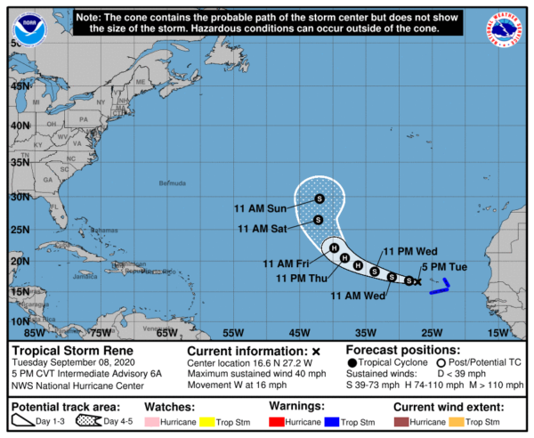
TROPICAL STORM RENE: Rene has winds of 40 mph in the eastern Atlantic. It is expected to briefly become a hurricane Thursday and Friday before weakening to a tropical storm again this weekend. It will turn sharply north by Saturday and is no threat to the U.S.
AFRICAN WAVE: A tropical wave is forecast to emerge off the west coast of Africa on Thursday. Gradual development is expected once the system moves over water, and a tropical depression is likely to form late this week or over the weekend while the system moves generally westward across the eastern tropical Atlantic. Way too early to know if this will threaten the U.S. Just something to watch.
The Gulf of Mexico will remain quiet through the upcoming weekend.
ON THIS DATE IN 1900: The Great Galveston hurricane made landfall at category four strength. It remains the deadliest natural disaster in United States history and the fourth-deadliest Atlantic hurricane overall. The hurricane left between 6,000 and 12,000 fatalities in the United States; the number most cited in official reports is 8,000. Most of these deaths occurred in and near Galveston, Texas, after storm surge inundated the coastline with 8 to 12 ft of water. In addition to the number killed, the storm destroyed about 7,000 buildings of all uses in Galveston, which included 3,636 demolished homes; every dwelling in the city suffered some degree of damage. The hurricane left approximately 10,000 people in the city homeless, out of a total population of nearly 38,000. The disaster ended the Golden Era of Galveston, as the hurricane alarmed potential investors, who turned to Houston instead. In response to the storm, three engineers designed and oversaw plans to raise the Gulf of Mexico shoreline of Galveston island by 17 feet and erect a 10 mile seawall.
BEACH FORECAST: Click here to see the AlabamaWx Beach Forecast Center page.
WEATHER BRAINS: Don’t forget you can listen to our weekly 90 minute show anytime on your favorite podcast app. This is the show all about weather featuring many familiar voices, including our meteorologists here at ABC 33/40.
CONNECT: You can find me on all of the major social networks…
Facebook
Twitter
Instagram
Pinterest
Snapchat: spannwx
Look for the next Weather Xtreme video here by 7:00 a.m. tomorrow…
Category: Alabama's Weather, ALL POSTS, Weather Xtreme Videos


