Tropical Storm Sally – Saturday Evening Update
EVENING UPDATE ON TROPICAL STORM SALLY: A Hurricane Watch is now in effect from Grand Isle Louisiana to the Alabama/Florida border, including Lake Pontchartrain, Lake Maurepas, and metropolitan New Orleans.
The hurricane watch includes all of the Alabama Gulf Coast.
A Storm Surge Watch is in effect from the Mouth of the Mississippi River to the Alabama/Florida Border, including Lake Pontchartrain, Lake Maurepas, Lake Borgne, and Mobile Bay.
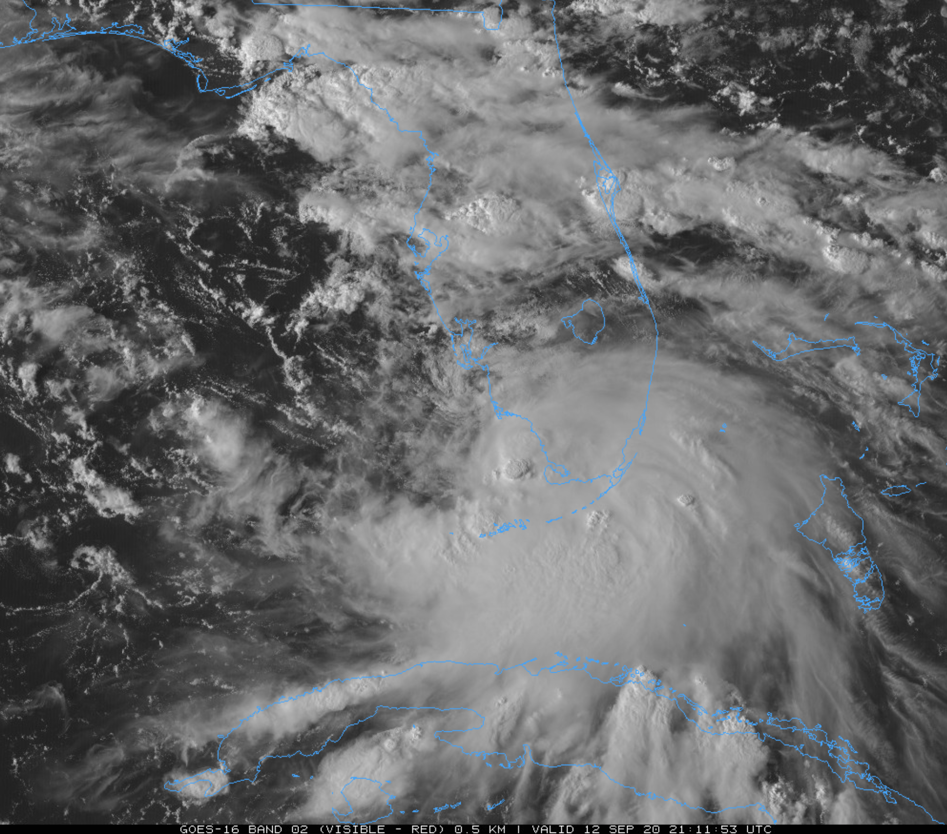
Sally has 40 mph winds, and is centered 30 miles south of Naples, Florida. Strengthening is likely as it moves into the open water of the Gulf of Mexico, and Sally is expected to become a hurricane Monday. It will be near the mouth of the Mississippi River Monday night with 85 mph winds; from there it turns northward and moves into South Mississippi.
The remnant circulation will move into Central Alabama Thursday.
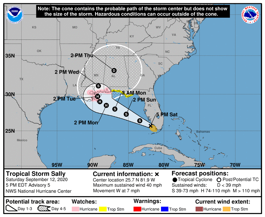
Don’t focus on the exact details of the track or intensity forecast as the average NHC track error at 96 hours is around 150 miles and the average intensity error is around 15 mph. In addition, winds, storm surge, and rainfall hazards will extend far from the center.
IMPACT ON THE CENTRAL GULF COAST: The combination of a dangerous storm surge and the tide will cause normally dry areas near the coast to be flooded by rising waters moving inland from the shoreline. The water could reach the following heights above ground somewhere in the indicated areas if the peak surge occurs at the time of high tide.
Currently NHC is forecasting a storm surge of 2 to 4 feet along the Alabama Gulf Coast, and along the shores of Mobile Bay. A surge of 1 to 3 feet is forecast for the Florida Gulf Coast from Perdido Pass to Saint Andrew Bay.
Hurricane conditions (winds of 75 mph or higher) are possible within the hurricane watch area, (including the Alabama Gulf Coast) by early Tuesday, with tropical storm conditions possible within the watch area by Monday. Winds could gust to 40/50 mph along the Florida coast.
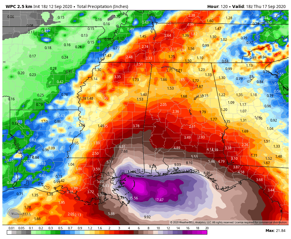
Sally is expected to produce rainfall amounts of 5 to 10 inches across the Florida Panhandle, and 6 to 12 inches with isolated amounts of 18 inches over the Central Gulf Coast (including the Alabama coast) from Sunday into the middle of next week. Sally is expected to be a slow moving system that will continue to produce heavy rainfall and considerable flooding near the central Gulf Coast through the middle of next week. Flash, urban and rapid onset flooding along small streams and minor to moderate flooding on rivers is likely.
A flash flood watch has been issued for Mobile and Baldwin counties.
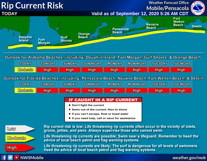
Swells are expected to spread northward along the west-central coast of Florida and reach the Florida Panhandle and the northern Gulf Coast during the next couple of days. These swells are likely to cause life-threatening surf and rip current conditions.
A few isolated waterspouts, or brief tornadoes are possible near the Gulf Coast Monday and Tuesday.
The weather will begin to improve along the coast Wednesday, with somewhat routine weather (sun and scattered storms) by Thursday and Friday.
If I am the coast, do I leave? If I have a trip planned this week, do I go? I would not want to be on Dauphin Island Monday or Tuesday due to storm surge flooding. Otherwise, conditions will be wet and windy on the coast from Gulf Shores to Panama City Beach Monday and Tuesday and some flooding is possible, especially along the Alabama Gulf Coast. Different people go to the beach for different reasons, so I can’t really answer those questions… just take this information and make a decision that is best for your family.
INLAND ALABAMA: Rain amounts of 2-5 inches are possible over inland parts of Alabama south of U.S. 84 (south of a line from Grove Hill to Evergreen to Dothan). Amounts of 2 to 3 inches are expected in the central part of the state, with 1-2 inches for North Alabama over the next five days.
Remember, this forecast can change, so be sure and keep updated over the rest of the weekend!
Category: Alabama's Weather, Tropical
About the Author (Author Profile)
James Spann is one of the most recognized and trusted television meteorologists in the industry. He holds the AMS CCM designation and television seals from the AMS and NWA. He is a past winner of the Broadcast Meteorologist of the Year from both professional organizations.Subscribe
If you enjoyed this article, subscribe to receive more just like it.


