Detailed Mid-Evening Look at Gulf Coastal, Central Alabama Impacts from Sally
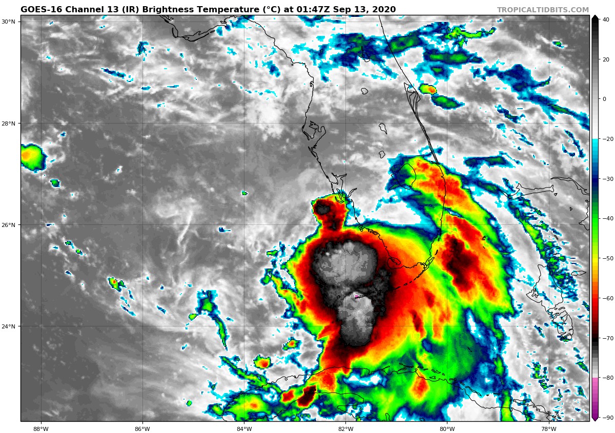
Tropical Storm Sally seems to be becoming better organized tonight over the far southeastern Gulf of Mexico as it pulls further away from Southwest Florida. Thunderstorms appear to be increasing on infrared satellite and the core of colder cloud tops is expanding. There is no plane in the storm right now, but another flight is expected to depart Biloxi before midnight and we will have continuous fixes tomorrow of course. Two NOOAA Gulfstream IV high altitude flights are scheduled on Sunday to support computer model operations.
There is no dry air threatening to be entrained into the system and see surface temperatures are warm, even if oceanic heat content is not extremely high. Wind shear is light, but the storm does not seem to have good outflow yet. The forecast is for slow and steady strengthening and Sally should become a hurricane by Monday morning.
There is some chance that it could intensify faster, as predicted by the HWRF model, which takes it all the way to a 120-125 mph hurricane, easily category 3 on Monday afternoon. We have to be alert to that potential. I think that Sally will have top winds of 100-105 mph as it nears the coast.
Here is a display of expected winds:
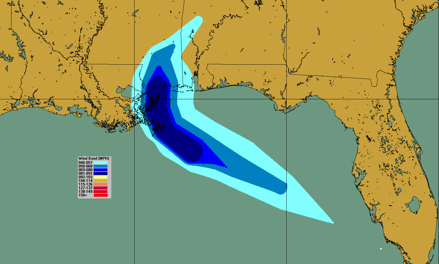
The official forecast is for a landfall near the Mouth of the Mississippi River early Tuesday morning, before sunrise, with the hurricane slowing its forward speed and making a northward turn. This turn and slowing would carry it to a final landfall near Bay. St. Louis, Mississippi around midnight after passing over eastern St. Benard Parish Tuesday evening. This will try to push a lot of water into Lake Borgne and Lake Pontchartrain around New Orleans. It will be a test for all of their new flood defenses built since Katrina.
Here are expected storm surge heights above dry normally dry ground:
…Mouth of the Mississippi River to Ocean Springs, MS including Lake Borgne…6-9 ft
…Ocean Springs, MS to MS/AL Border…4-6 ft
…MS/AL Border to AL/FL Border, including Mobile Bay…2-4 ft
…Lake Pontchartrain and Lake Maurepas…2-4 ft
…AL/FL Border to Chassahowitzka, FL, including Pensacola Bay, Choctawhatchee Bay, and Saint Andrew Bay…1-3 ft
Extremely heavy rainfall amounts on the order of 15 to 25 inches are possible across much of southern and southeastern Louisiana, southern Mississippi, southern Alabama and the Florida Panhandle starting on Monday and continuing until at least Thursday. This could lead to serious flooding. 5-10 inches of rain could fall across parts of the Florida Panhandle, Southwest Alabama, southern Mississippi, and Southeast Louisiana, with some 6-12 inch amounts. This would cause serious flooding in some areas.
The heavier rain will move into Central Alabama on Wednesday with 1-2 inches likely. It will continue into Thursday with another 1-2 inches and another inch on Friday. Central Alabama totals could reach 3-4 inches by Friday along and south of the I-20 Corridor with 2-3 inches across North Alabama.
Tornadoes will be possible across coastal sections of Northwest Florida and Alabama Monday afternoon, spreading into Southwest and West Central Alabama on Tuesday and Tuesday night. Tornadoes will be possible late Tuesday starting over Southwest Alabama, moving into West Central Alabma Tuesday night, and into Central Alabama Wednesday.
SPECIFIC IMPACTS
PANAMA CITY/ST. JOE
TROPICAL STORM WATCH IN EFFECT
Partly sunny today. Mostly cloudy Monday and Tuesday. A slight chance of showers and storm through the period. Seas running 1-2 feet, but rip current risk becoming high later today and especially tonight and Monday through Tuesday. Highs will be in the middle and upper 80s. Winds today will be out of the east at 20 mph, and southeast at 15-20 mph on Monday. Tuesday, winds will be southeast around 15 mph. Tides will run 1-2 feet above normal Monday and lasting into Tuesday. Moderate rip current risk today, becoming high tonight and staying high through Tuesday. Flash flood watches are in effect from Sunday morning through Tuesday evening.
SANDESTIN/BEACHES OF 30A
TROPICAL STORM WATCH IN EFFECT
Mostly sunny today, becoming mostly cloudy tonight and Monday. Mostly cloudy through Wednesday. Slight chance of showers and storms through Wednesday. Surf running 1-2 feet today, increasing to 2-3 feet Monday and 3-5 feet Tuesday. East and southeast winds 15-20 mph. Highs in the upper 80s today, and lower 80s Monday and Tuesday. Tides will run 2-3 feet above normal Monday and Tuesday. Moderate rip current risk today, becoming high tonight and staying high through Tuesday. Flash flood watches are in effect from Sunday morning through Tuesday evening.
PENSACOLA BEACH/NAVARRE/FORT WALTON
TROPICAL STORM WATCH IN EFFECT
Mostly sunny today, becoming mostly cloudy tonight and Monday. Mostly cloudy through Wednesday. Slight chance of showers and storms through Monday night. Showers and storms like Tuesday through Wednesday. Surf running 1-2 feet today, increasing to 2-3 feet Monday and 3-5 feet Tuesday. East and southeast winds 15-20 mph. Highs in the upper 80s today, mid-80s Monday, and lower 80s Tuesday. Tides will run 2-3 feet above normal Monday and Tuesday. Moderate rip current risk today, becoming high tonight and staying high through Tuesday. Flash flood watches are in effect from Monday morning through Thursday morning.
ALABAMA COAST
HURRICANE WATCH IN EFFECT
Mostly sunny today, becoming mostly cloudy tonight and Monday with a chance of showers and storms. Showers and storms Tuesday and Wednesday. Surf running 3-4 feet today, increasing to 10-11 feet Monday and Monday night, dropping to around 7 feet Tuesday. East 10-15 mph today mph, shifting to northeast and increasing to 25 mph on Monday. Winds will increase to around 40 mph Monday night and stay breezy through Tuesday night, averaging 25 mph. Highs in the upper 80s today, mid-80s Monday, and lower 80s Tuesday. Tides will run 2-4 feet above normal Monday and Tuesday. Moderate rip current risk today, becoming high tonight and staying high through Tuesday. Flash flood watches are in effect from Monday morning through Thursday morning.
MISSISSIPPI GULF COAST
HURRICANE WATCH IN EFFECT
Partly cloudy today becoming cloudy Monday through Tuesday. A chance of showers and storms today, with a good chance ono Monday. Rain and storms likely Tuesday and Wednesday. Winds E 10-15 mph today, increasing to 15-30 mph with gusts to 35 mph Monday. Tropical storm and even hurricane conditions likely on Tuesday. The stronger winds will arrive on the coast around Bay. St. Louis and Pass Christian around 7 p.m. Tuesday with winds could run 80-90 mph with gusts to over 100 mph. Bay. St. Louis and surrounding areas could experience the eye and eyewall. Winds will remain above hurricane force until early morning Wednesday, with tropical storm force sustained winds until mid-morning Wednesday. Tropical storm gusts will continue much of the day Wednesday. Highs will be near 90F today, in the middle 80s on Monday, near 80F on Tuesday, and lower 80s Wednesday. Tides will be increasing, reaching 4-6 feet east of Oceans Springs starting late Monday into Tuesday and 6-9 feet west of Ocean Springs, in places like Biloxi, Gulfport, Bay. St. Louis, and Pass Christian.
NEW ORLEANS
HURRICANE WATCH IN EFFECT
Partly cloudy and hot today with scattered showers and storms. Winds NE 6-12 mph. increasing clouds with showers and storms becoming likely on Monday. Winds increasing tot 15-20 mph with gusts to 30-35 mph on Monday. Those winds will increase to tropical storm force around sunrise Tuesday morning out of the north, The highest winds will occur during the early afternoon and could reach 45-50 mph with gusts to 55-60 mph. Winds will not drop below tropical storm force until around 10 p.m. Tropical storm gusts will continue into Wednesday. Tides will rise to 2-4 feet in Lake Ponchartrain and Lake Maurepas. A flash flood watch is in effect from Sunday evening through late Wednesday night. 4-8 inches of rain is expected in New Orleans.
CENTRAL ALABAMA
We will not feel any real impacts from Sally until Wednesday. Winds will be gusty at times south of I-59 and east of I-65 this afternoon. Monday should be fairly calm with a light easterly breeze and increasing clouds, along with a few scattered showers and storms. Winds will become breezy on Tuesday, gusting to 20 mph at time, and 30 mph during the nighttime hours as Sally turns north and northeast. Winds will gust to over 35 mph on Wednesday and wind advisories may be necessary. Heavy rain will move into Southwest and West Central Alabama Tuesday and Wednesday. Periods of heavy rain will be a threat through Thursday.
Central Alabama rainfall totals could reach 3-4 inches by Friday along and south of the I-20 Corridor with 2-3 inches across North Alabama. Tornado will be possible late Tuesday over West Central and into Wednesday over Central Alabama.
We will have the latest forecast advisory at 10 p.m. and be back with the very latest starting at 4 a.m. tomorrow. Look for continuous coverage through Thursday here on AlabamaWX.
Category: Alabama's Weather, ALL POSTS, Tropical
About the Author (Author Profile)
Bill Murray is the President of The Weather Factory. He is the site's official weather historian and a weekend forecaster. He also anchors the site's severe weather coverage. Bill Murray is the proud holder of National Weather Association Digital Seal #0001 @wxhistorianSubscribe
If you enjoyed this article, subscribe to receive more just like it.


