Sally Remains Somewhat Disorganized Tonight, Still Forecast to be a Hurricane by Monday Night
SUMMARY OF 1100 PM EDT…0300 UTC…INFORMATION
———————————————–
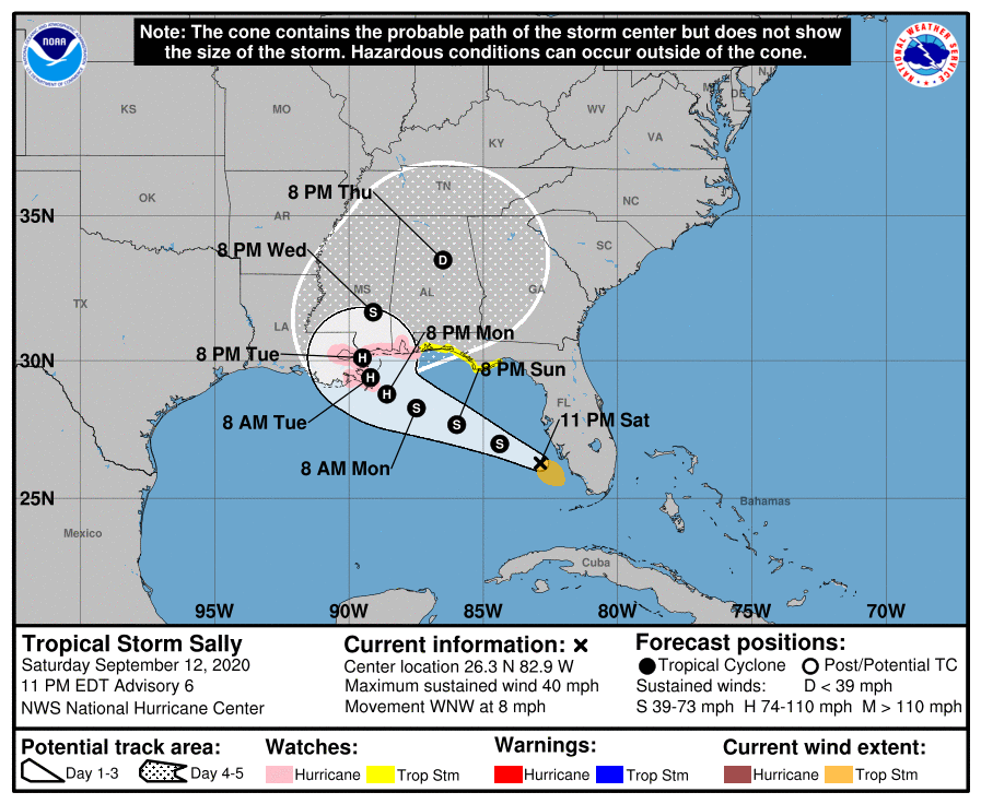
LOCATION…26.3N 82.9W
ABOUT 70 MI…110 KM SW OF PORT CHARLOTTE FLORIDA
ABOUT 425 MI…685 KM ESE OF THE MOUTH OF THE MISSISSIPPI RIVER
MAXIMUM SUSTAINED WINDS…40 MPH…65 KM/H
PRESENT MOVEMENT…WNW OR 285 DEGREES AT 8 MPH…13 KM/H
MINIMUM CENTRAL PRESSURE…1003 MB…29.62 INCHES
WATCHES AND WARNINGS
——————–
A Storm Surge Watch is in effect for…
* Mouth of the Mississippi River to the Alabama/Florida border
* Lake Pontchartrain, Lake Maurepas, and Lake Borgne
* Mobile Bay
A Hurricane Watch is in effect for…
* Grand Isle Louisiana to the Alabama/Florida border
* Lake Pontchartrain and Lake Maurepas including metropolitan New Orleans
A Tropical Storm Watch is in effect for…
* Alabama/Florida Border to Ochlockonee River Florida
DISCUSSION AND OUTLOOK
———————-
At 1100 PM EDT (0300 UTC), the center of Tropical Storm Sally was located near latitude 26.3 North, longitude 82.9 West. Sally is moving toward the west-northwest near 8 mph (13 km/h), and a west-northwestward or northwestward motion is expected through Monday. A decrease in forward speed and a turn toward the north-northwest is forecast on Tuesday. On the forecast track, the center of Sally will move over the southeastern and eastern Gulf of Mexico tonight and Sunday, move over the north-central Gulf of Mexico Sunday night and Monday, and approach the north-central Gulf Coast within the hurricane watch area late Monday and Tuesday.
Maximum sustained winds are near 40 mph (65 km/h) with higher gusts. An Air Force Reserve Hurricane Hunter Aircraft will investigate Sally overnight. Strengthening is expected over the next couple of days, and Sally is forecast to become a hurricane on Monday, with some additional strengthening possible through early Tuesday.
Tropical-storm-force winds extend outward up to 80 miles (130 km), mainly to the southeast of the center. A wind gust of 39 mph (63 km/h) was recently reported in Key West, Florida.
The estimated minimum central pressure is 1003 MB (29.62 inches).
HAZARDS AFFECTING LAND
———————-
STORM SURGE: The combination of a dangerous storm surge and the tide will cause normally dry areas near the coast to be flooded by rising waters moving inland from the shoreline. The water could reach the following heights above ground somewhere in the indicated areas if the peak surge occurs at the time of high tide…
The mouth of the Mississippi River to Ocean Springs, MS including Lake Borgne…6-9 ft
Ocean Springs, MS to MS/AL Border…4-6 ft
MS/AL Border to AL/FL Border, including Mobile Bay…2-4 ft
Lake Pontchartrain and Lake Maurepas…2-4 ft
AL/FL Border to Chassahowitzka, FL, including Pensacola Bay,
Choctawhatchee Bay, and Saint Andrew Bay…1-3 ft
The deepest water will occur along the immediate coast near and to the right of the landfall location, where the surge will be accompanied by large and damaging waves. Surge-related flooding depends on the relative timing of the surge and the tidal cycle and can vary greatly over short distances. For information specific to your area, please see products issued by your local National Weather Service forecast office.
WIND: Hurricane conditions are possible within the hurricane watch area by early Tuesday, with tropical storm conditions possible within the watch areas by Monday.
Wind gusts to tropical storm force are possible across the lower Florida Keys overnight.
RAINFALL: Sally is expected to produce additional rainfall amounts of 2 to 4 inches with locally higher amounts possible over southern Florida and the Florida Keys through Sunday. Rainfall amounts of 2 to 4 inches with isolated amounts of 6 inches are expected along the west coast of Florida through Sunday. This rainfall will produce flash and urban flooding across southern Florida and prolong high flows and ongoing minor flooding on rivers across central Florida.
Sally is expected to produce rainfall amounts of 5 to 10 inches across the Florida Panhandle, and 6 to 12 inches with isolated amounts of 18 inches over the Central Gulf Coast from Sunday into the middle of next week, with 3 to 6-inch rainfall amounts possible over inland portions of Mississippi and Alabama. Sally is expected to be a slow-moving system that will continue to produce heavy rainfall and considerable flooding near the central Gulf Coast through the middle of next week. Flash, urban, and rapid onset flooding along small streams and minor to moderate flooding on rivers are likely.
SURF: Swells will spread northward along the west-central coast of Florida and reach the Florida Panhandle and the northern Gulf Coast during the next couple of days. These swells are likely to cause life-threatening surf and rip current conditions. Please consult products from your local weather office.
TORNADOES: A tornado is possible tonight along the south Florida Gulf Coast.
Category: Alabama's Weather, ALL POSTS, Severe Weather, Tropical
About the Author (Author Profile)
Scott Martin is an operational meteorologist, professional graphic artist, musician, husband, and father. Not only is Scott a member of the National Weather Association, but he is also the Central Alabama Chapter of the NWA president. Scott is also the co-founder of Racecast Weather, which provides forecasts for many racing series across the USA. He also supplies forecasts for the BassMaster Elite Series events including the BassMaster Classic.Subscribe
If you enjoyed this article, subscribe to receive more just like it.


