Tropical Storm Sally – Sunday Evening Update
Sally continues to strengthen in the Gulf of Mexico; sustained winds are now 65 mph, and the system is expected to become a hurricane tonight or tomorrow morning.
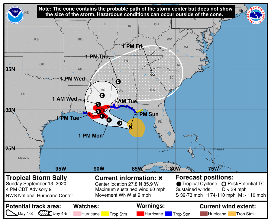
Not much change in the forecast track from NHC; Sally is expected to make landfall across Southeast Louisiana tomorrow night at category two strength.
Do not focus on the exact details of the track or intensity forecasts; wind, storm surge, and rainfall hazards will extend far from the center. Unfortunately, confidence is increasing that Sally’s expected slow forward speed near the Gulf Coast will exacerbate the storm surge and heavy rainfall threats.
A Storm Surge Warning is in effect for…
* Port Fourchon Louisiana to the Mississippi/Alabama Border
* Lake Pontchartrain, Lake Maurepas, and Lake Borgne
A Hurricane Warning is in effect for…
* Grand Isle Louisiana to Ocean Springs Mississippi
* Lake Pontchartrain and Lake Maurepas including metropolitan New Orleans
A Storm Surge Watch is in effect for…
* The Alabama Gulf Coast
A Hurricane Watch is in effect for…
* East of Ocean Springs to the Alabama/Florida Border, including the Alabama Gulf Coast
A Tropical Storm Warning is in effect for…
* East of Ocean Springs to Indian Pass, including the Alabama Gulf Coast.
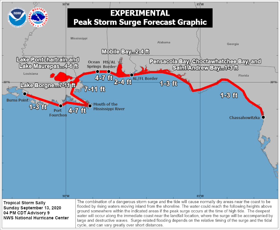
STORM SURGE: The combination of a dangerous storm surge and the tide will cause normally dry areas near the coast to be flooded by rising waters moving inland from the shoreline. The water could reach the following heights above ground somewhere in the indicated areas if the peak surge occurs at the time of high tide…
Mouth of the Mississippi River to Ocean Springs, MS including Lake Borgne…7-11 ft
Port Fourchon, LA to Mouth of the Mississippi River…4-7 ft
Ocean Springs, MS to MS/AL Border…4-7 ft
Lake Pontchartrain and Lake Maurepas…4-6 ft
The Alabama Gulf Coast, including Mobile Bay…2-4 ft
AL/FL Border to Chassahowitzka, FL including Pensacola Bay, Choctawhatchee Bay, and Saint Andrew Bay…1-3 ft
Burns Point, LA to Port Fourchon, LA…1-3 ft
WIND: Hurricane conditions are expected within the hurricane warning area starting late tomorrow, with hurricane conditions possible within the hurricane watch area by early Tuesday. Tropical storm conditions are possible within the watch area by Monday, and within the warning area late Monday.
Sustained winds of 30-40 mph are likely along the Alabama Gulf Coast late tomorrow and Tuesday, with potential gusts to 75 mph in spots. Along the Northwest Florida coast, sustained winds of 20-30 mph are likely, with gusts possible to 50 mph.
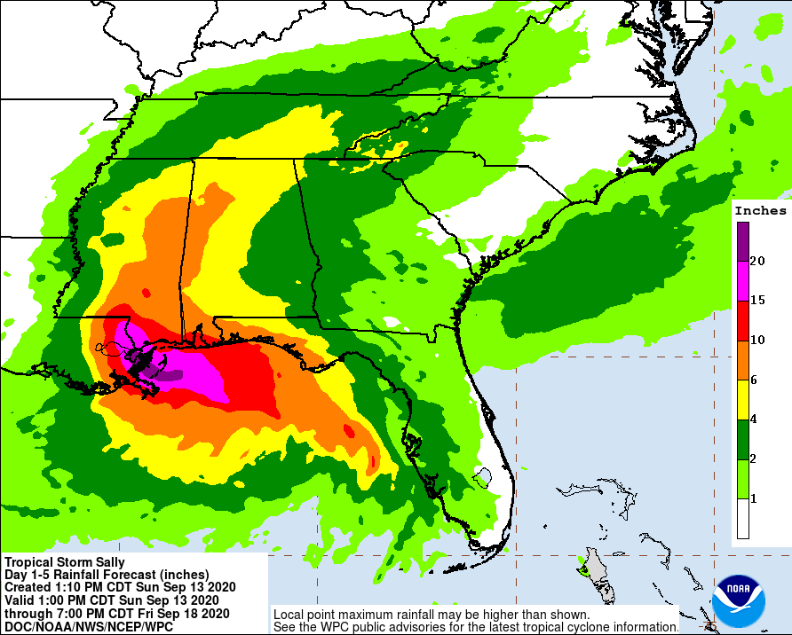
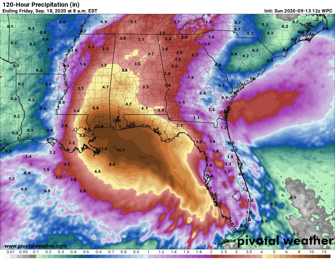
RAIN: Sally is expected to be a slow moving system resulting in significant flash flooding for the central Gulf Coast tomorrow into Wednesday. Sally is expected to produce rainfall of 8 to 16 inches with isolated amounts of 24 inches over portions of the central Gulf Coast from the western Florida Panhandle to southeast Louisiana from Monday through the middle of the week. This rainfall will likely result in new widespread minor to isolated major
flooding on area rivers.
Sally is forecast to move inland early Wednesday and track into the Southeast with rainfall of 5 to 10 inches possible across much of inland Mississippi and Alabama. Flash and urban flooding is possible, as well as widespread minor to moderate flooding on some rivers in Mississippi and Alabama.
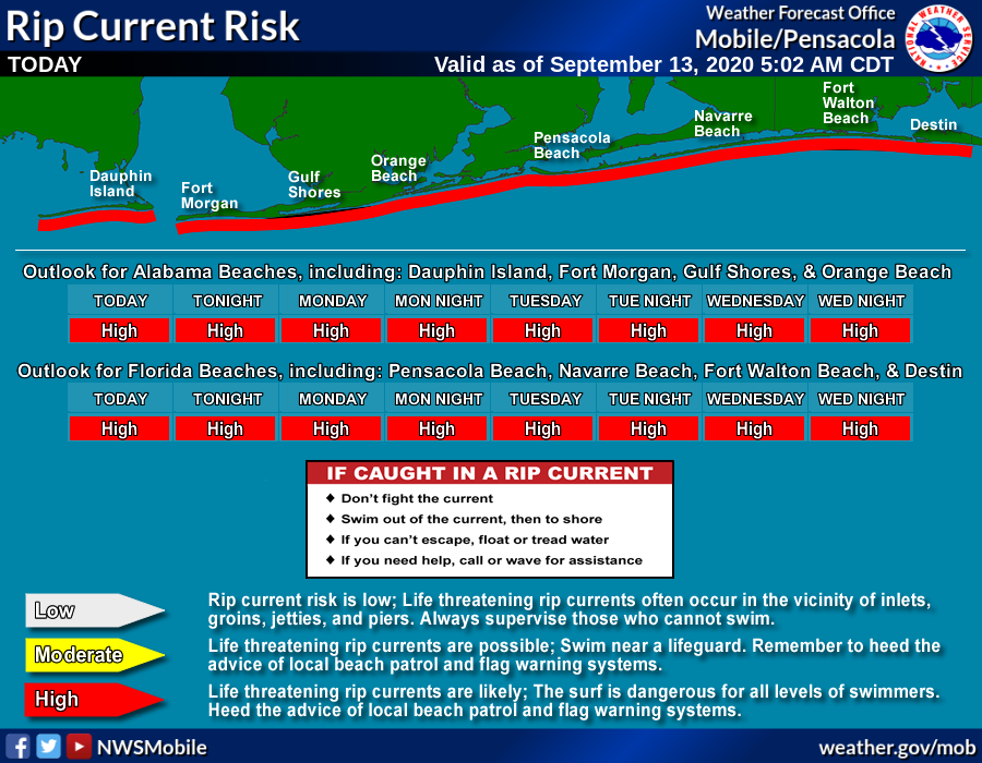
RIP CURRENTS: Swells will spread northward along the west-central coast of Florida and reach the Florida Panhandle and the northern Gulf Coast during the next couple of days. These swells are likely to cause life-threatening surf and rip current conditions. Expect double red flags.
A few isolated tornadoes or brief waterspouts are also possible along the Gulf Coast Monday and Tuesday.
WHAT TO DO: This is for those along the coast from Dauphin Island east to Panama City Beach. At this point the hurricane warning is just to the west of the Alabama Gulf Coast, but a tropical storm warning is in effect for this entire region, as far east as Indian Pass. Today will be a pretty decent weather day other than the rip current danger. but conditions will deteriorate tomorrow, with lots of rain and windy conditions through Tuesday night. Flooding is the greatest concern, with totals of 6-12 inches likely. I would not want to be on Dauphin Island during this event due to the storm surge potential, but elsewhere I don’t expect any evacuation orders, and hotels and restaurants should operate as usual. The weather will begin to improve Wednesday, and rather routine weather is likely Thursday and Friday.
I can’t make the decision on whether to cancel a trip, or leave early, since different people go to the beach for different reasons. The detailed information in this discussion will help you and your family to make the right decision for you.
INLAND ALABAMA: Rain amounts of 4-6 inches are likely across the southwest counties of the state, with totals of 3-4 inches elsewhere across North/Central Alabama. The most widespread rain for inland areas will come Wednesday and Thursday as the remnant circulation curves into the northern part of the state. For now the tornado threat looks very low; instability is forecast to be very weak.
As always, keep up with the latest forecasts tonight and tomorrow and watch for any changes.
About the Author (Author Profile)
James Spann is one of the most recognized and trusted television meteorologists in the industry. He holds the AMS CCM designation and television seals from the AMS and NWA. He is a past winner of the Broadcast Meteorologist of the Year from both professional organizations.Subscribe
If you enjoyed this article, subscribe to receive more just like it.


