Flooding Rain Possible Across Much Of Alabama By Wednesday
EYES ON SALLY: Hurricane Sally in the Gulf of Mexico will determine Alabama’s weather for the rest of the week, but this afternoon is quiet with just a few widely scattered showers over the northern half of the state. It is a warm September afternoon with temperatures between 85 and 90 degrees; the sky is partly sunny. Evening showers will end after sunset, and the weather should be pretty quiet overnight.
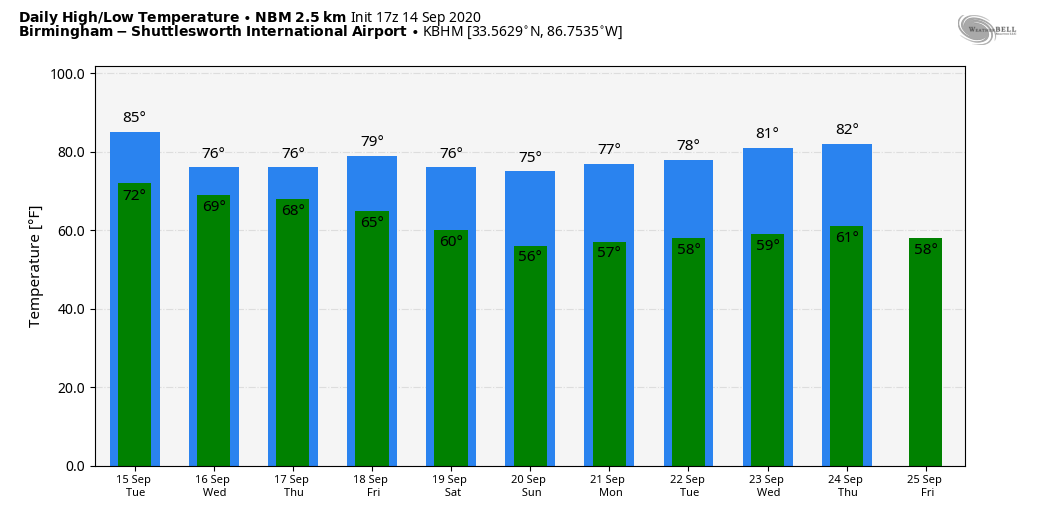
The sky becomes mostly cloudy tomorrow, and scattered showers are possible during the day, especially tomorrow afternoon. The high will be in the low 80s for most communities.
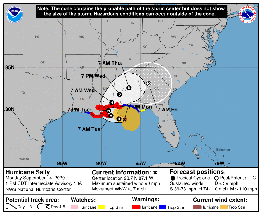
WEDNESDAY/THURSDAY: Sally is expected to make landfall along the Mississippi coast tomorrow night, and then slowly moving through Central Alabama as a depression, or remnant low, Wednesday and Wednesday night. On the positive side, the slow motion should allow the system to weaken considerably before getting into our state, so we are not expecting any major wind issues. Winds on Wednesday will be in the 15-25 mph range, with gusts to 30 mph. Yes, windy, but nothing like the wind generated by past hurricanes like Opal, Ivan, or Frederic. No widespread power outages are expected.
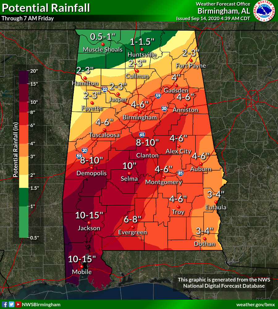
But, on the negative side, the slow motion means potential for excessive rain. A flash flood watch is in effect from roughly I-20 south, and rain amounts will be in the 10-15 inch range for Southwest Alabama, 6-10 inches for much of the central counties, and 1/2 to 1 inch for the Tennessee Valley of far North Alabama. Wednesday will be mostly a wash-out with rain throughout the day, heavy at times. It continues Wednesday night.
There is a low end threat of a few brief, isolated tornadoes over the southern half of the state Wednesday and Wednesday night. For now instability values look fairly low, thankfully. But you always have to watch these type tropical systems for a few “spin-ups”.
We expect the rain to end from west to east during the day Thursday, and drier air will move into the state Thursday night. Highs will be only in the 70s Wednesday and Thursday because of clouds and rain.
FRIDAY AND THE WEEKEND: The weather looks delightful for the northern half of the state. Partly to mostly sunny pleasant days, and fair cool nights. Highs around 80, lows between 57 and 62. It will feel like fall. A few showers are possible over the weekend over the southern third of the state, but they should be pretty isolated.
NEXT WEEK: The pleasant weather continues with comfortable days and cool nights. The week is looking mostly dry, although a front could bring a few showers late in the week. See the Weather Xtreme video for maps, graphics, and more details.
SALLY: Sally, which intensified rather rapidly this morning, now is packing sustained winds of 90 mph, and is 125 miles east/southeast of the mouth of the Mississippi River. It is moving to the west/northwest at only 7 mph. Landfall is expected tomorrow night on the Mississippi Coast at category two strength.
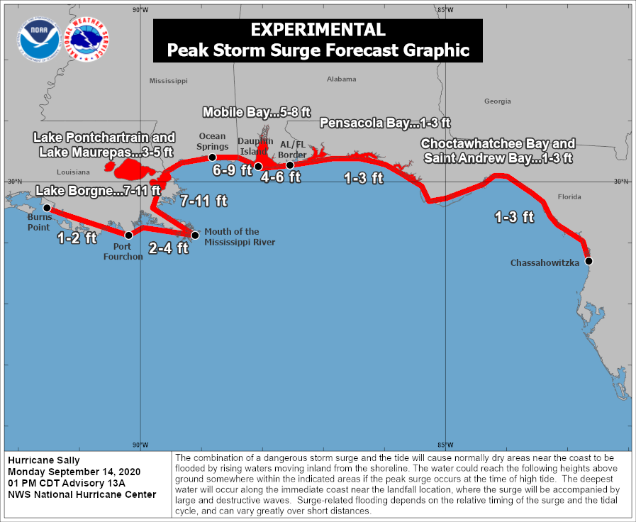
The hurricane warning was adjusted eastward this morning, and now includes all of the Alabama Gulf Coast. A storm surge of 6-9 feet is now forecast for Dauphin Island and southern Mobile County… the surge for Mobile Bay is forecast to be 5-8 feet, and 4-6 feet in Baldwin County from Fort Morgan to Perdido Pass.
Emergency Management officials are now advising all visitors and residents in Zones 1 and 2 on either side of Mobile Bay (Mobile and Baldwin counties) evacuate before Hurricane Sally’s landfall. These zones are over the southern part of these coastal counties.
Alabama beaches were closed at 3pm today.
Sustained winds on Dauphin Island and the Mobile County coastal communities will be in the 60-80 mph range late tomorrow and tomorrow night with higher gusts. Sustained winds from Fort Morgan to Gulf Shores and Orange Beach will be 30-50 mph with gusts possible to 75 mph.
REST OF THE TROPICS: There are four other named systems now across the Atlantic basin, but none of these will impact the U.S. thankfully.

ON THIS DATE IN 2008: Hurricane Ike became extratropical on this day. The St. Louis Metropolitan Area experienced hurricane conditions, with Ike’s remnants inflicting severe damage to homes. Several areas in Illinois and Indiana, already flooded by the frontal boundary to the north, saw significant additional rainfall. Due to flooding in Chicago, a state of emergency was declared for Cook County due to flooding of the Des Plaines River. Hurricane-force wind gusts were reported to the east of the center across parts of Kentucky, Indiana, Ohio, and Pennsylvania with significant wind damage including structural damage to buildings and trees.
BEACH FORECAST: Click here to see the AlabamaWx Beach Forecast Center page.
WEATHER BRAINS: Don’t forget you can listen to our weekly 90 minute show anytime on your favorite podcast app. This is the show all about weather featuring many familiar voices, including our meteorologists here at ABC 33/40.
CONNECT: You can find me on all of the major social networks…
Facebook
Twitter
Instagram
Pinterest
Snapchat: spannwx
Look for the next Weather Xtreme video here by 7:00 a.m. tomorrow…
Category: Alabama's Weather, ALL POSTS, Weather Xtreme Videos
About the Author (Author Profile)
James Spann is one of the most recognized and trusted television meteorologists in the industry. He holds the AMS CCM designation and television seals from the AMS and NWA. He is a past winner of the Broadcast Meteorologist of the Year from both professional organizations.Subscribe
If you enjoyed this article, subscribe to receive more just like it.


