Hurricane Sally – Monday Evening Update
MONDAY EVENING UPDATE ON HURRICANE SALLY
Sally is now packing sustained winds of 100 mph, and is still expected to be a category two at the time of landfall on the Mississippi coast tomorrow night.
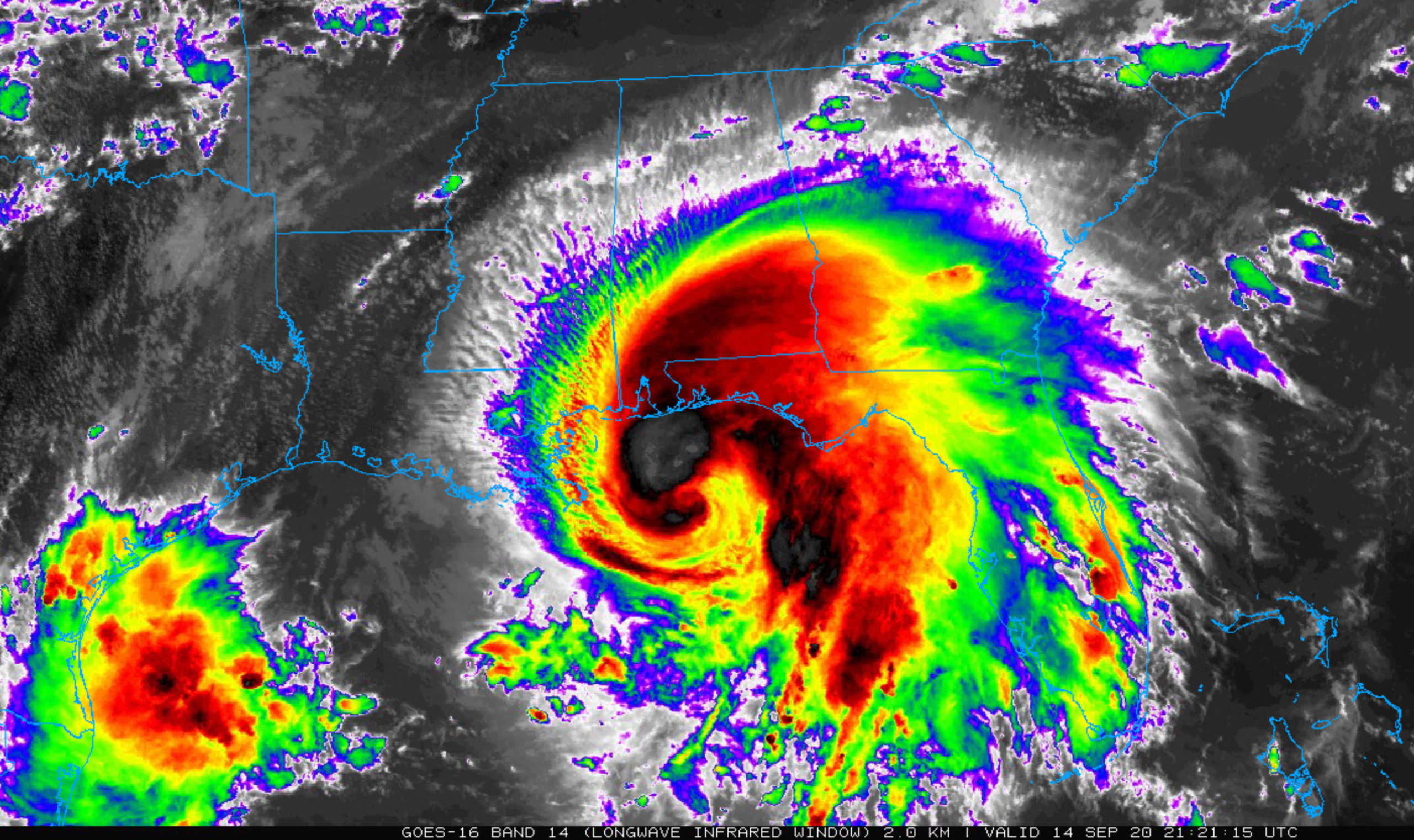
Potential upwelling from the slow moving system and shear should prevent it from becoming a major, category three hurricane.
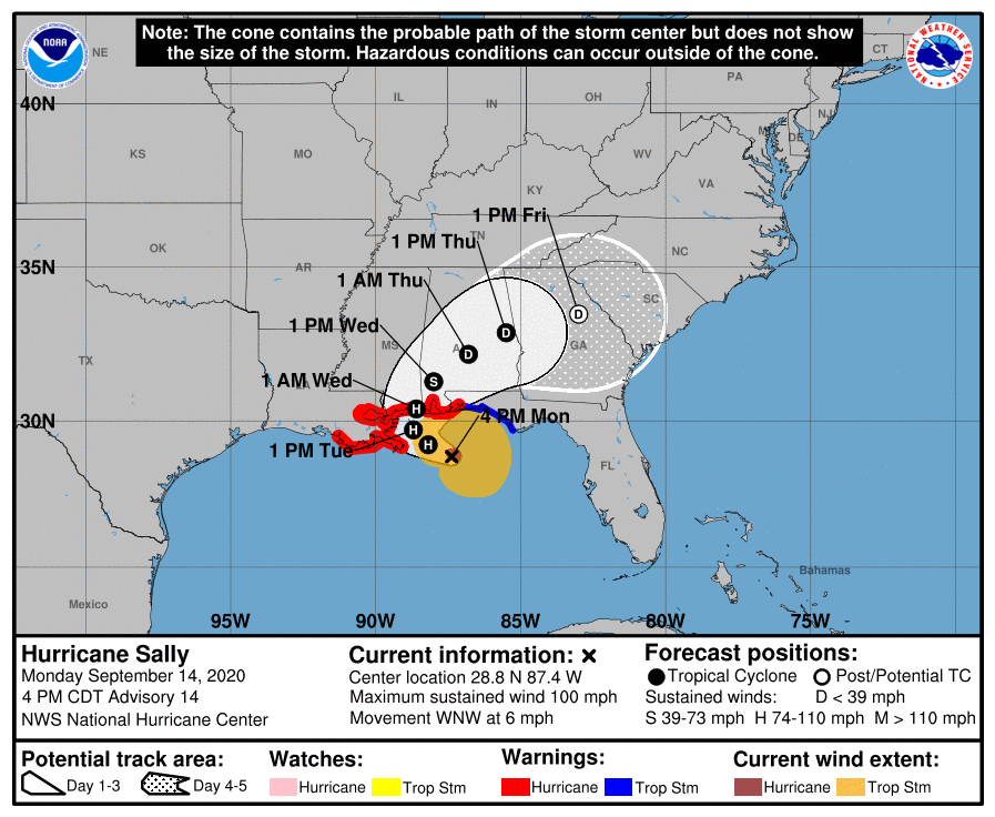
Given the uncertainty in the timing and location of the northward turn and the lack of well-defined steering currents, don’t focus on the exact forecast track or the specific timing and location of landfall. Hurricane-force winds, dangerous storm surge, and flooding rainfall will affect a large portion of the north-central Gulf Coast during the next few days.
A Storm Surge Warning is in effect for…
* Port Fourchon Louisiana to the Okaloosa/Walton County Line Florida
* Lake Pontchartrain, Lake Maurepas, and Lake Borgne
* Mobile Bay
A Hurricane Warning is in effect for…
* Morgan City Louisiana to the Navarre Florida. This includes all of the Alabama coast.
* Lake Pontchartrain and Lake Maurepas including metropolitan New Orleans
A Tropical Storm Warning is in effect for…
* East of of Navarre Florida to Indian Pass Florida
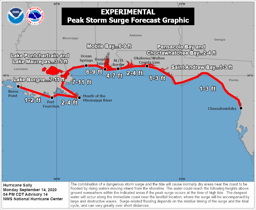
STORM SURGE: The combination of a dangerous storm surge and the tide will cause normally dry areas near the coast to be flooded by rising waters moving inland from the shoreline. The water could reach the following heights above ground somewhere in the indicated areas if the peak surge occurs at the time of high tide…
Mouth of the Mississippi River to Ocean Springs, MS including Lake Borgne…7-11 ft
Ocean Springs, MS to Dauphin Island, AL including Mobile Bay…6-9 ft
Dauphin Island, AL and the Alabama Gulf Coast..4-7 ft
Lake Pontchartrain and Lake Maurepas…3-5 ft
Port Fourchon, LA to Mouth of the Mississippi River…2-4 ft
AL/FL Border to Okaloosa/Walton County Line, FL including Pensacola Bay and Choctawhatchee Bay…2-4 ft
Okaloosa/Walton County Line, FL to Chassahowitzka, FL including Saint Andrew Bay…1-3 ft
Burns Point, LA to Port Fourchon, LA…1-2 ft
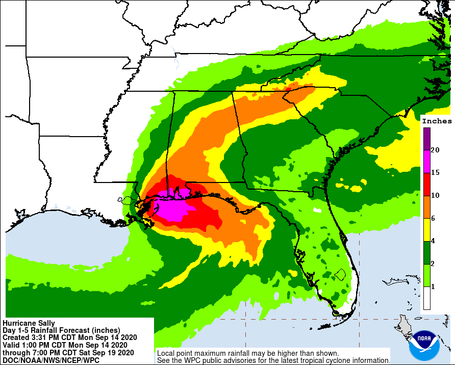
RAINFALL: Sally is expected to be a slow moving system as it approaches land, producing 8 to 16 inches of rainfall with isolated amounts of 24 inches over portions of the central Gulf Coast from the western Florida Panhandle to far southeast Louisiana through the middle of the week. Life-threatening flash flooding is likely. In addition, this rainfall will likely lead to widespread minor to isolated major flooding on area rivers.
Sally is forecast to move farther inland early Wednesday and track across the Southeast producing rainfall of 4 to 8 inches, with isolated maximum amounts of 12 inches, across portions of eastern Mississippi, central Alabama, northern Georgia and the western Carolinas. Significant flash and urban flooding is likely, as well as widespread minor to moderate flooding on some rivers.
Outer bands of Sally are expected to produce additional rainfall of 1 to 3 inches across the Florida peninsula today. This rainfall may produce flash and urban flooding and prolong high flows and ongoing minor flooding on rivers across central Florida.
TORNADOES: A tornado or two are possible through tonight over coastal areas of the Florida Panhandle and southern Alabama. The threat of tornadoes is expected to increase on Tuesday in these areas, as well as over parts of southern Mississippi and extreme southeast Louisiana.
SURF: Swells from Sally will continue to affect areas from the west coast of the Florida peninsula westward through the coast of southeastern Louisiana during the next couple of days. These swells are likely to cause life-threatening surf and rip current conditions.
EVACUATIONS: Evacuations are recommended for those in Zones 1 and 2 in Mobile and Baldwin counties.
INLAND ALABAMA: Hurricane Sally in the Gulf of Mexico will determine Alabama’s weather for the rest of the week, but this afternoon is quiet with just a few widely scattered showers over the northern half of the state. It is a warm September afternoon with temperatures between 85 and 90 degrees; the sky is partly sunny. Evening showers will end after sunset, and the weather should be pretty quiet overnight.
The sky becomes mostly cloudy tomorrow, and scattered showers are possible during the day, especially tomorrow afternoon. The high will be in the low 80s for most communities.
WEDNESDAY/THURSDAY: Sally is expected to make landfall along the Mississippi coast tomorrow night, and then slowly moving through Central Alabama as a depression, or remnant low, Wednesday and Wednesday night. On the positive side, the slow motion should allow the system to weaken considerably before getting into our state, so we are not expecting any major wind issues. Winds on Wednesday will be in the 15-25 mph range, with gusts to 30 mph. Yes, windy, but nothing like the wind generated by past hurricanes like Opal, Ivan, or Frederic. No widespread power outages are expected.
But, on the negative side, the slow motion means potential for excessive rain. A flash flood watch is in effect from roughly I-20 south, and rain amounts will be in the 10-15 inch range for Southwest Alabama, 6-10 inches for much of the central counties, and 1/2 to 1 inch for the Tennessee Valley of far North Alabama. Wednesday will be mostly a wash-out with rain throughout the day, heavy at times. It continues Wednesday night.
Stay tuned for updates!
Category: Alabama's Weather, Tropical
About the Author (Author Profile)
James Spann is one of the most recognized and trusted television meteorologists in the industry. He holds the AMS CCM designation and television seals from the AMS and NWA. He is a past winner of the Broadcast Meteorologist of the Year from both professional organizations.Subscribe
If you enjoyed this article, subscribe to receive more just like it.


