Lower Humidity Levels Today; Dry Pattern Continues
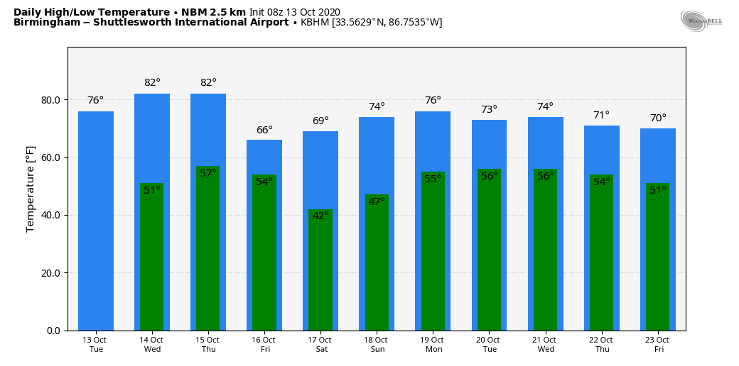
DEW POINTS COMING DOWN: A cold front passed through Alabama early this morning in mostly dry fashion, and today will feature temperatures about 5 degrees cooler than yesterday, but humidity levels will be noticeably lower. With a good supply of sunshine, most places will see a high in the upper 70s this afternoon. Tonight will be clear and cool with a low in the 47-52 degree range.
REST OF THE WEEK: After the cool start, we warm into the low to mid 80s tomorrow afternoon with a sunny sky. Thursday will be mostly sunny with a high in the low 80s; then a cold front passes through Thursday night. Moisture will be very limited, but a few light showers are possible. Then, on Friday, the weather will be much cooler in the wake of the front. The sky will be sunny, but the high will only in the low to mid 60s with a cool north breeze.
THE ALABAMA WEEKEND: Saturday morning will feature the coldest temperatures so far this season for many communities. Lows will be in the 33-43 degree range for most places with scattered frost. Then, during the day Saturday, the sky will be sunny with a high between 67 and 70. Sunny weather continues Sunday with a high in the mid 70s; it will be a picture perfect autumn weekend.
NEXT WEEK: Monday will be dry, but we are now seeing evidence a few showers could return to the state Tuesday or Wednesday ahead of the next cold front. Rain amounts will be light… See the Weather Xtreme video for maps, graphics, and more details.
TROPICS: A tropical wave and associated broad area of low pressure located about 600 miles east of the Windward Islands have changed little in organization this morning. Upper-level winds are gradually becoming less conducive, so only some slow additional development is possible today. By tonight, upper-level winds are expected to become even less favorable for tropical cyclone formation to occur. The rest of the Atlantic basin is quiet.
RAIN UPDATE: These are rain totals for the year so far, and the departure from average…
Muscle Shoals 64.26″ (+23.56″)
Birmingham 63.73″ (+21.41″)
Huntsville 60.02″ (+18.66″)
Montgomery 58.75″ (+16.92″)
Tuscaloosa 56.75″ (+15.98″)
Anniston 53.39″ (+14.39″)
Troy 50.55″ (+7.47″)
Mobile 49.30″ (-4.43″)
ON THIS DATE IN 2006: The October 2006 Buffalo storm was an unusual early-season lake effect snowstorm that hit the Buffalo, New York area, and other surrounding areas of the United States and Canada. Downtown Buffalo reported 15 inches from this event. Depew and Alden record 24 inches, the most from this lake effect storm.
BEACH FORECAST: Click here to see the AlabamaWx Beach Forecast Center page.
WEATHER BRAINS: Don’t forget you can listen to our weekly 90 minute show anytime on your favorite podcast app. This is the show all about weather featuring many familiar voices, including our meteorologists here at ABC 33/40.
CONNECT: You can find me on all of the major social networks…
Facebook
Twitter
Instagram
Pinterest
Snapchat: spannwx
Look for the next Weather Xtreme video here by 4:00 this afternoon…enjoy the day!
Category: Alabama's Weather, ALL POSTS, Weather Xtreme Videos
About the Author (Author Profile)
James Spann is one of the most recognized and trusted television meteorologists in the industry. He holds the AMS CCM designation and television seals from the AMS and NWA. He is a past winner of the Broadcast Meteorologist of the Year from both professional organizations.Subscribe
If you enjoyed this article, subscribe to receive more just like it.


