Cold And Dry Weather For Alabama
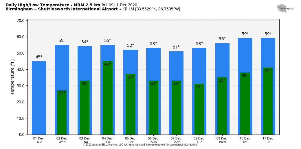
SUB-FREEZING START: Temperatures are in the 20s all the way down to the Gulf Coast this morning; Mobile reports 28 degrees just before daybreak. The sky is clear, but a west wind persists, keeping temperatures in the mid 20s over North Alabama. Today will be sunny with a high between 45 and 50 over the northern half of the state… the average high for Birmingham on December 1 is 60.
Tonight will be just as cold, if not colder than last night as the wind should be calm. By daybreak tomorrow look for lows between 20 and 29 degrees, and another freeze is likely down to the coast. Then, a warming trend begins tomorrow afternoon as temperatures rise into the 50s.
RAIN RETURNS: Clouds will increase Thursday ahead of a slow moving upper low to the west, and some rain will likely reach West Alabama by late afternoon. It now looks like the most widespread rain statewide with this system will come Thursday night into Friday morning, with the rain ending from west to east during the afternoon hours Friday. Moisture will be limited; rain amounts of 1/4 to 1/2 inch look likely. Highs will be in the 50s both days.
THE ALABAMA WEEKEND: The cold core upper low will pass just north of Alabama Saturday. While most of the state will be in a dry slot, some moisture could wrap into the Tennessee Valley of far North Alabama with some scattered light rain possible. But, for most of the state the day will be dry with a partly sunny sky. Highs will be in the 40s over North Alabama, with 50s for the rest of the state. Then, Sunday will be mostly sunny with a high in the low to mid 50s.
NEXT WEEK: For now the week looks cool and dry with highs mostly in the 50s, and lows in the 30s. See the Weather Xtreme video for maps, graphics, and more details.
MONDAY’S SNOW: As expected, snow flurries and showers developed in the cold air across Alabama yesterday. Heaviest snow was in Marshall County, where a lake effect snow band set up as a fetch of air moved over the Tennessee River, enhancing snow rates there (along with the upslope effect). About one inch accumulated on grassy areas, but roads were just wet.
DECEMBER CLIMATOLOGY: Welcome to December. The average high/low at Birmingham drops from 60/30 today to 54/34 by the end of the month. The month can feature some very active weather, and is in the core of the late fall/early winter tornado season in Alabama. The average rain for the month at Birmingham is 4.45″. While snow is still relatively rare, it can happen in December. Parts of North Alabama had a “White Christmas” on December 25, 2010 with amounts of 2-4 inches in scattered pockets.
ON THIS DATE IN 2006: A winter storm produced more than 6 inches of snow along a 1,000-mile-long path from central Oklahoma to northern Michigan from November 30-December 1st. The storm also produced significant freezing rain, which impacted the St. Louis area. An estimated 500 or more homes and businesses were without power in the St. Louis area after this storm.
BEACH FORECAST: Click here to see the AlabamaWx Beach Forecast Center page.
WEATHER BRAINS: Don’t forget you can listen to our weekly 90 minute show anytime on your favorite podcast app. This is the show all about weather featuring many familiar voices, including our meteorologists here at ABC 33/40.
CONNECT: You can find me on all of the major social networks…
Look for the next Weather Xtreme video here by 4:00 this afternoon… enjoy the day!
Category: Alabama's Weather, ALL POSTS, Weather Xtreme Videos
About the Author (Author Profile)
James Spann is one of the most recognized and trusted television meteorologists in the industry. He holds the AMS CCM designation and television seals from the AMS and NWA. He is a past winner of the Broadcast Meteorologist of the Year from both professional organizations.Subscribe
If you enjoyed this article, subscribe to receive more just like it.


