Freezing Fog Early This Morning; Isolated Showers Later Today
ICY BRIDGES: Fog is fairly widespread across Alabama early this morning, and with temperatures below freezing, the “freezing fog” is creating ice on bridges and overpasses. Many wrecks have already been reported; be VERY careful if you are driving early this morning. Temperatures will be above freezing by 9:00 a.m.
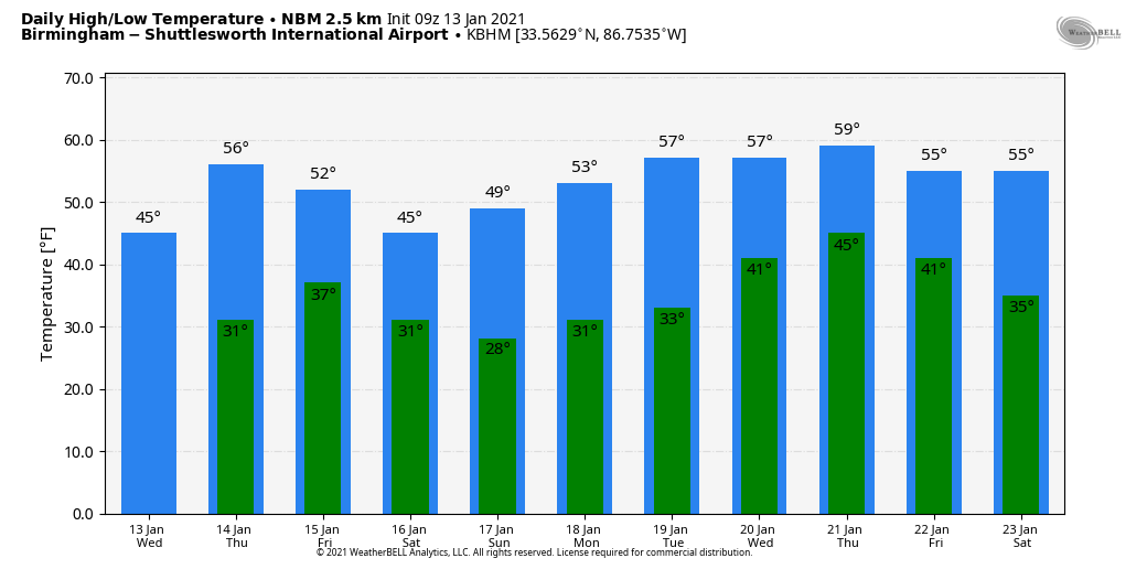
Otherwise, today will feature more clouds than sun, and we will mention the chance of a few isolated showers this afternoon as an upper trough swings through the Deep South. Moisture is very limited, so odds of any one spot getting wet are only about one in ten. The high today will be in the upper 40s for most places.
Tomorrow will be the warmest day of the week; we reach the mid to upper 50s with a partly to mostly sunny sky. Then, a cold front rolls through early Friday morning with another shot of colder air. Some patchy light rain can’t be totally ruled out when the front passes through, but most places will see no rain. Temperatures on Friday will settle into the 40s with a chilly northwest wind… we do expect some sun through scattered clouds.
THE ALABAMA WEEKEND: Dry weather continues Saturday; we start the day in the upper 20s, followed by a high in the upper 40s with a partly sunny sky. Clouds will increase Sunday afternoon ahead of another approaching cold front, but the day should be dry with a high around 50. A few sprinkles are possible Sunday night over the Tennessee Valley, but once again moisture is lacking and that front should come through in mostly dry fashion.
NEXT WEEK: Monday and Tuesday will be dry with highs in the 50s; some rain is likely Tuesday night into Wednesday with the next wave moving into the state from the west; for now it looks like rain amounts will be under 1/2 inch. Dry weather returns Thursday and Friday. Still no sign of any bitterly cold air, snow, ice, heavy rain, or severe thunderstorms for Alabama during the next 10 days. See the Weather Xtreme video for maps, graphics, and more details.
ON THIS DATE IN 1982: While Alabama was in the midst of a catastrophic ice storm, there was a weather related aviation disaster in Washington, D.C. Air Florida Flight 90 was headed to Fort Lauderdale-Hollywood International Airport. Moments after takeoff, the plane with 74 passengers and five crew members failed to maintain altitude and slammed into the bridge, striking seven occupied vehicles and plummeting into the Potomac. Four passengers and one flight attendant were rescued; four motorists on the bridge were killed.
The official cause of the crash was pilot error. When the pilots failed to activate the anti-icing systems, the snow in the engines caused compression instruments to read incorrectly, making the pilots think they had more power than they actually. The reduced power (about 70%) and ice covered wings caused the crash.
BEACH FORECAST: Click here to see the AlabamaWx Beach Forecast Center page.
WEATHER BRAINS: Don’t forget you can listen to our weekly 90 minute show anytime on your favorite podcast app. This is the show all about weather featuring many familiar voices, including our meteorologists here at ABC 33/40.
CONNECT: You can find me on all of the major social networks…
Look for the next Weather Xtreme video here by 4:00 this afternoon… enjoy the day!
Category: Alabama's Weather, ALL POSTS, Weather Xtreme Videos
About the Author (Author Profile)
James Spann is one of the most recognized and trusted television meteorologists in the industry. He holds the AMS CCM designation and television seals from the AMS and NWA. He is a past winner of the Broadcast Meteorologist of the Year from both professional organizations.Subscribe
If you enjoyed this article, subscribe to receive more just like it.


