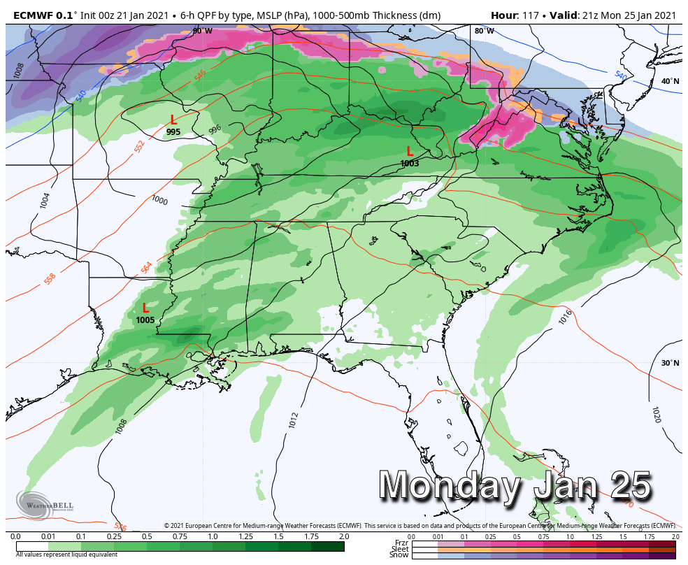
Occasional Rain Through Tomorrow
WET IS THE WORD: The combination of a stalled surface front, and an upper wave approaching from the west will bring cloudy, wet weather to Alabama over the next 36 hours. Look for periods of rain today, tonight, and tomorrow; rain amounts of around 1 inch are likely. No risk of severe storms, probably no thunder. We do note the far northern part of Alabama could get into drier air tomorrow, so places like Muscle Shoals, Athens, and Huntsville could be rain-free a decent part of the day. But, for a large majority of the state occasional rain continues.
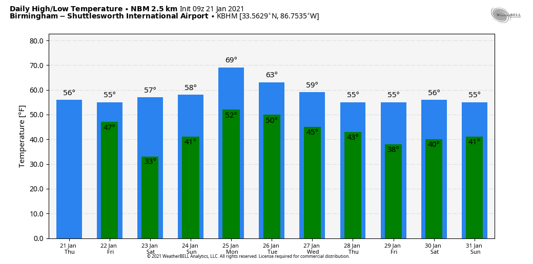
The high today will be in the low 60s over the southern 2/3 of the state, with upper 50s to the north. Highs tomorrow will be in the 50s as the front sags southward.
THE ALABAMA WEEKEND: Saturday will bring a break in the rain; the sky will be mostly sunny with a high in the mid 50s. And, the latest model data suggests a decent part of the day Sunday will be dry as well, although a few showers could develop over the northwest part of the state late in the day. We rise into the low 60s Sunday afternoon.
STRONG STORMS MONDAY: A deep surface low will develop northwest of Alabama Monday, and a moist, unstable airmass will move up into the state with potential for temperatures to reach the low 70s. This will bring showers and thunderstorms statewide, and confidence is increasing that we will have potential for strong to possibly severe thunderstorms by afternoon. Still too early to be really specific, but just be aware that Monday could be an active weather day.
REST OF NEXT WEEK: Tuesday looks dry, but another disturbance will bring some rain to the state late Tuesday night into part of the day Wednesday. Dry weather returns Thursday and Friday. The high Tuesday will be in the low to mid 60s, followed by 50s each day for the rest of the week. See the Weather Xtreme video for maps, graphics, and more details.
ON THIS DATE IN 1985: A deep Arctic cold wave covered much of the Deep South. The official low at Birmingham was -6F, the second coldest temperature on record for the city. Other lows included -11F at Huntsville and Muscle Shoals, 0F at Montgomery, and 3F at Mobile. Jacksonville, Florida recorded its all-time record low of 7 degrees.
ON THIS DATE IN 1999: A major tornado outbreak occurred from southwest into central and northeast Arkansas during the afternoon and evening. In the Little Rock Area, 30 tornadoes tracked across 15 counties. Homes and businesses were damaged or destroyed in areas like Little Rock, Beebe, McRae, and in areas farther north and east. Eight deaths resulted from the tornadoes with 140 to 150 injuries also reported.
BEACH FORECAST: Click here to see the AlabamaWx Beach Forecast Center page.
WEATHER BRAINS: Don’t forget you can listen to our weekly 90 minute show anytime on your favorite podcast app. This is the show all about weather featuring many familiar voices, including our meteorologists here at ABC 33/40.
CONNECT: You can find me on all of the major social networks…
Look for the next Weather Xtreme video here by 3:00 this afternoon… enjoy the day!
Category: Alabama's Weather, ALL POSTS, Weather Xtreme Videos
About the Author (Author Profile)
James Spann is one of the most recognized and trusted television meteorologists in the industry. He holds the AMS CCM designation and television seals from the AMS and NWA. He is a past winner of the Broadcast Meteorologist of the Year from both professional organizations.Subscribe
If you enjoyed this article, subscribe to receive more just like it.


