Sunday Weather Xtreme: Low End Severe Threat Ahead of Squall Line Today; High Pressure Builds in for Monday
There’s no rest for the weary as the severe weather keeps on coming for Alabama. The good news is that today’s event looks nothing like the one last week or the one on St. Patrick’s Day, but we have to take them all seriously. The other good news is that there is an extended dry and storm-free period on the horizon. But let’s get through this system and one at midweek first.
SATURDAY WARMTH: An increasing Spring sun led to record warmth across Central Alabama on Saturday. Tuscaloosa reached 86F to establish a new record, and Anniston hit 84F, also a record. The warmth caused scattered strong storms to develop and a couple became severe. There were a few reports of damaging winds across parts of Madison, Cullman, Marshall, and Jackson Counties. There were a couple of reports of large hail as well. All of the activity calmed down after sunset with the loss of daytime heating.
APPROACHING TROUGH AND COLD FRONT: Our attention turned to areas to our west and northwest as evening set In as a broken line of storms became severe, producing damaging winds, a few tornadoes, and large hail. The storms have been efficient rainmakers as well, and a flash flood watch is in effect for our North Alabama counties. Extreme flooding has been reported overnight in the Nashville Metro area. The storms congealed into a powerful squall line overnight over northern Mississippi, and that squall line reached Northwest Alabama after midnight. It continues to push southeastward this morning ahead of a cold front. Damaging winds have been the primary concern, but with decent low-level wind shear in spots, isolated tornadoes have been a threat as well. The line of storms will continue pushing southeastward, and weakening slowly, but the threat of damaging winds remains and we can’t rule out an isolated tornado in the line.
WATCHES: A tornado watch remains in effect for a few counties ahead of the line, and beyond those counties, a severe thunderstorm watch continues until 10 a.m. for a few more counties across Central Alabama.
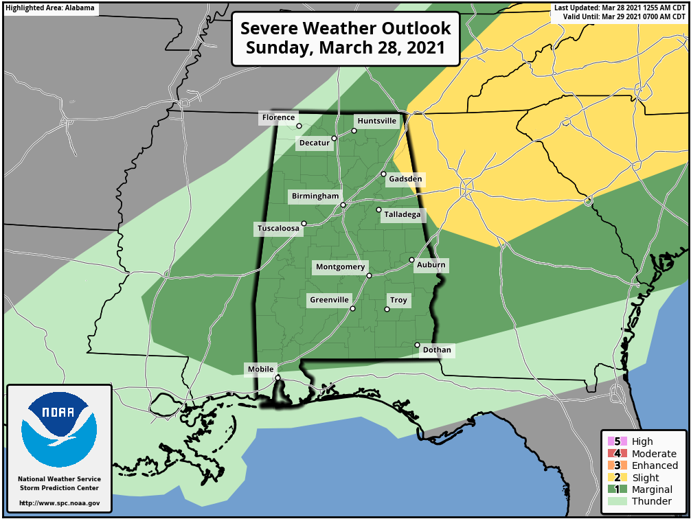
SEVERE WEATHER RISK TODAY: There is a “Marginal” severe weather risk across much of Alabama today ahead of the line of storms. That is a level 1 on a scale that goes to five as issued by the Storm Prediction Center. Damaging winds will be the primary threat, but we can’t rule out a tornado, especially over East Central Alabama.
BEHIND THE STORMS: Winds will shift to the northwest behind the front, which should be following on the heels of the line of storms. Those winds will be a little on the brisk side, but the gusts should die down pretty quickly. Skies will remain mostly cloudy most of the morning, although there will be a few peeks of sunshine at times. Highs will be limited to the upper 60s behind the front, with 70s limited to areas south of I-85. Even there, readings will fall back during the day. Lows tonight will drop into the 40s, with a few upper 30s over northern sections.
FAIR FOR MONDAY AND MOST OF TUESDAY: High pressure will build in over Alabama and much of the Southeast on Monday and Tuesday. Highs will be in the upper 60s Monday, with lower 70s on Tuesday. Monday night lows will be in the 40s.
MOISTURE SURGES BACK: By Tuesday night, moisture return will be in full swing across the area. Rain will return overnight, with thunderstorms and rain likely on Wednesday. There could be some threat of severe weather by afternoon across South Central Alabama. It is something we will be monitoring between now and then. Some areas could pick up another inch or so of rain.
COOLER TO END THE WEEK: It will be much colder by Thursday, with lows in the 30s across the area and highs limited to the 50s. It will be windy as well, with clearing skies. Thursday night lows will be flirting with freezing across northern parts of the area. Friday highs will be brisk as well, struggling to reach 60 degrees. Highs will gradually warm through the 60s Saturday and Sunday under fair skies.
EXTENDED DRY PERIOD: It looks like we will be rain and storm-free for an extended period that will last for a week or so. The next rain chances may not return until Wednesday the 7th.
BEACHCAST: It will be an up and down week weather-wise along the beautiful beaches of Alabama and Northwest Florida. Expect rain and storms today, and again on Monday, Tuesday and Wednesday. Cooler temps will follow for the weekend. Lows will drop into the 40s by Friday and Saturday morning.
Click here to see the Beach Forecast Center page.
DANCING WITH THE STATS: Yesterday’s rainfall total for Nashville was 5.75″. This was the largest daily rainfall ever recorded in March and ranks as the 4th-wettest day in Nashville’s history.
1) 7.25″ (May 2, 2010)
2) 6.60″ (September 13, 1979)
3) 6.32″ (May 1, 2010)
4) 5.75″ (March 27, 2021)
WEATHERBAND: The American Meteorological Society has created a club for all of us! The weather enthusiasts of the world! You will connect with weather enthusiasts and experts alike. Special Weather Band items will identify you with the community. You’ll get special discounts on WeatherWise magazine and other merchandise as well as a special newsletter! Join today! https://amsweatherband.org/index.cfm/weatherband/membership/
ADVERTISE WITH US: Deliver your message to a highly engaged audience by advertising on the AlabamaWX.com website. The site enjoyed over 27 MILLION page views in the past 12 months. Don’t miss out! We can customize a creative, flexible and affordable package that will suit your organization’s needs. Contact me, Bill Murray, at (205) 687-0782, and let’s talk.
WEATHERBRAINS: This week, the panel will discuss the tornadoes that hit the state on Thursday. Check out the show at www.WeatherBrains.com. You can also subscribe on iTunes. You can watch the show live at live.bigbrainsmedia.com or on James’ YouTube Channel You will be able to see the show on the James Spann 24×7 weather channel on cable or directly over the air on the dot 2 feed.
ON THIS DATE IN 1955: Marianna, Florida picked up one inch of snow for the latest measurable snow in the Sunshine State. The ground was whitened in Panama City. Follow my weather history tweets on Twitter. I am @wxhistorian at Twitter.com.
Category: Alabama's Weather, ALL POSTS, Severe Weather
About the Author (Author Profile)
Bill Murray is the President of The Weather Factory. He is the site's official weather historian and a weekend forecaster. He also anchors the site's severe weather coverage. Bill Murray is the proud holder of National Weather Association Digital Seal #0001 @wxhistorianSubscribe
If you enjoyed this article, subscribe to receive more just like it.


