Another Beautiful Day; Rain/Storms Return Wednesday Night
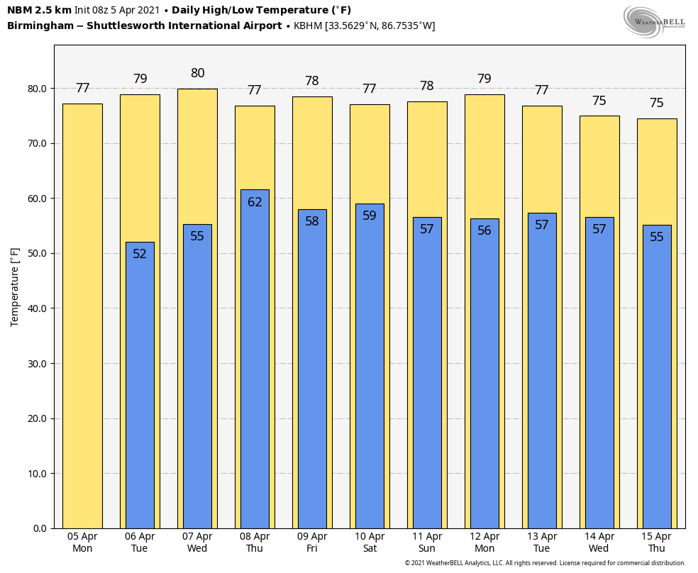
SPECTACULAR SPRING WEATHER: We are forecasting another beautiful spring day across Alabama; lots of sunshine with a high in the mid 70s for most communities. The average high for Birmingham on April 5 is 74. We dry tomorrow with a partly to mostly sunny sky… the high will be in the 77-80 degree range.
RAIN RETURNS: The day Wednesday looks dry with a mix of sun and clouds, but a band of rain and thunderstorms will push into the state late Wednesday night ahead of a slow moving cold front. SPC has defined a “marginal risk” (level 1/5) for parts of West Alabama… generally west of a line from Athens to Linden to Chatom.
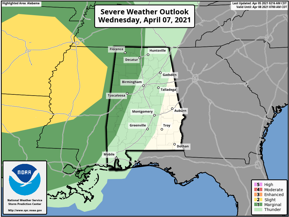
For now it looks like the storms will be weakening as they enter West Alabama Wednesday night sometime after 10:00 p.m. But, they could still produce strong winds and some hail. A low chance of a brief, isolated tornado.
Storms will end early Thursday morning as a dry slot moves into the state… a decent part of the day Thursday looks dry with some sun possible and a high in the upper 70s. Then, another wave rotating around an upper low to the north will bring another batch of rain and storms into the state Thursday night. Again, they could be fairly heavy with strong winds and some hail possible.
Then, during the day Friday, the best chance of showers and storms will shift down into South Alabama. Friday’s high will be in the mid 70s.
THE ALABAMA WEEKEND: For now Saturday looks relatively dry with only a small risk of a shower… the day will be warm with a high around 80 degrees. We will mention scattered showers statewide Sunday, but not a “wash-out”. The high Sunday will be in the upper 70s.
NEXT WEEK: Scattered showers remain possible Monday… then after a couple of dry days Tuesday and Wednesday more showers and storms are possible Thursday and Friday as the active spring pattern continues. Way too early to know if severe storms will be an issue… See the Weather Xtreme video for maps, graphics, and more details.
ON THIS DATE IN 1977: A large, violent F5 tornado began around 3 pm CST, 4 miles northwest of Birmingham near U.S. Highway 78, and then traveled northeast for 15 miles at 60 mph, crossing the Smithfield Estates neighborhood and then I-65. At it’s widest point, the tornado was 3/4 of a mile wide. Over 150 homes were damaged with almost 50 destroyed. A total of 22 people were killed with over 130 injured. Daniel Payne College near U.S. Highway 78 sustained heavy damage from this massive tornado with estimates over $1 million dollars. The college, opened in 1880, later closed its doors in 1977, likely a result of the enormous cost and amount of damage. There were six other tornadoes on this day including five F2 tornadoes and an F3 tornado across North and Central Alabama.
Many people do not know that the famous Dr. Theodore Fujita, for whom the Tornado Fujita Intensity Scale is named after, followed this massive tornado and supercell thunderstorm from an airplane. After tracking the storm, Dr. Fujita surveyed the damage and toyed with the idea of rating the Smithfield tornado an F6.
The same thunderstorm complex was responsible for the crash of Southern Airways Flight 242 in Georgia; it was a flight from Huntsville to Atlanta. The passenger jet went down after suffering hail damage and losing thrust on both engines; Sixty-three people on the aircraft (including the flight crew) and nine people on the ground died; twenty passengers survived, as well as the two flight attendants. One of the initial survivors succumbed to his injuries several weeks later.
BEACH FORECAST: Click here to see the AlabamaWx Beach Forecast Center page.
WEATHER BRAINS: Don’t forget you can listen to our weekly 90 minute show anytime on your favorite podcast app. This is the show all about weather featuring many familiar voices, including our meteorologists here at ABC 33/40.
CONNECT: You can find me on all of the major social networks…
Look for the next Weather Xtreme video here by 3:00 this afternoon… enjoy the day!
Category: Alabama's Weather, ALL POSTS, Weather Xtreme Videos
About the Author (Author Profile)
James Spann is one of the most recognized and trusted television meteorologists in the industry. He holds the AMS CCM designation and television seals from the AMS and NWA. He is a past winner of the Broadcast Meteorologist of the Year from both professional organizations.Subscribe
If you enjoyed this article, subscribe to receive more just like it.


