

Midday Nowcast: Increasing Storm Threat for Saturday
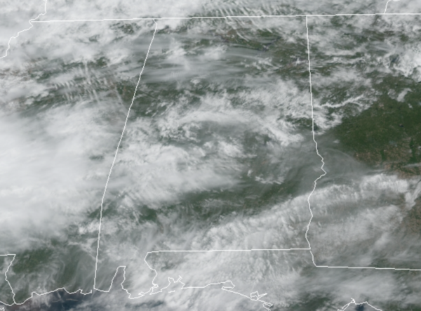
Clouds have been increasing across Alabama today, with a few light showers here and there, but most locations are remaining dry. Temperatures this afternoon are approaching the low 70s for most location. To the west of Alabama, severe weather is developing across ARKLATEX, and that is heading towards Alabama tonight, setting up an a wet and stormy Saturday for the state.
TWO ROUNDS OF STORMS EXPECTED: A dynamic storm system is allowing for severe storms to develop today west of Alabama, these will organize into a MCS (Mesoscale Convective System) and will move into Alabama later tonight, after midnight this will be round one of two rounds of storms we will deal with over the next 36 hours. Be sure to have multiple, reliable ways to receive severe weather alerts, and be prepared to act if and when watches and warning are issued.
This first round will arrive in Alabama after midnight tonight, and will rapidly push through the state during the pre-dawn and early morning hours tomorrow; main timeframe will be 2AM-9AM. In the new day one convective outlook, which runs until 7AM tomorrow morning, the SPC has much of South Alabama under a “slight risk” (level 2/5) for severe storms, with a “marginal risk” (level 1/5) for areas as far north of a line from Tuscaloosa to Auburn.
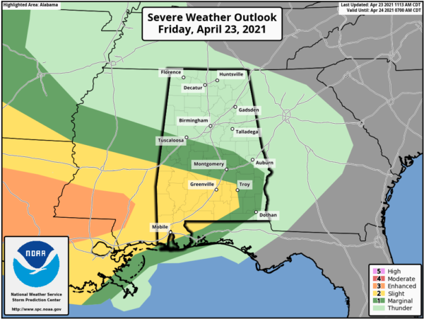
This round will produce widespread rain and storms, and the rainfall could be heavy at times, possibly leading to flash flooding issues. These storms will be capable of producing damaging winds, some hail, and some tornadoes, with the greatest chance for tornadoes across the southern half of the state. By mid-morning this round will be out of the state, and we should see a lull in the activity for several hours.
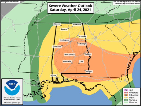
Round two will occur tomorrow afternoon as the actual front approaches the state. For tomorrow, in the new update from SPC just out, all of Alabama in a risk for severe weather with much of the state in an “Enhanced Risk” (level 3/5).
Ahead of the front, the air is expected to become unstable due to daytime heating, but also very cold air aloft will move in over the state. Additional showers and storms should develop in this environment and some of these storms could be strong to severe. These storms could produce very large hail (larger than golfballs) due to the cold air aloft and also could produce damaging straight-line winds…the wind profiles become somewhere unidirectional by afternoon, so the tornado threat looks very low tomorrow afternoon. The main timing for these storms looks to 1PM-7PM.
Also, all of the state will see a good soaking, with rain amounts of 1-2 inches likely across North/Central Alabama, while amounts of 3-4 inches are possible down towards the south. Some flash flooding issues could develop during the day.
BEACH FORECAST CENTER: Get the latest weather and rip current forecasts for the beaches from Fort Morgan to Panama City on our Beach Forecast Center page. There, you can select the forecast of the region that you are interested in visiting.
WORLD TEMPERATURE EXTREMES: Over the last 24 hours, the highest observation outside the U.S. was 113.0F at Nara, Mali. The lowest observation was -101.4F at University Dome, Antarctica.
CONTIGUOUS TEMPERATURE EXTREMES: Over the last 24 hours, the highest observation was 97F at Death Valley, CA. The lowest observation was -7F at Climax, CO.
WEATHER ON THIS DATE IN 1885: The city of Denver, CO, was in the midst of a storm which produced 23 inches of snow in 24 hours, and at Idaho Springs CO produced 32 inches of snow.
Category: Alabama's Weather, ALL POSTS, Severe Weather
About the Author (Author Profile)
Macon, Georgia Television Chief Meteorologist, Birmingham native, and long time Contributor on AlabamaWX. Stormchaser. I did not choose Weather, it chose Me. College Football Fanatic. @Ryan_StinnetSubscribe
If you enjoyed this article, subscribe to receive more just like it.


