A Quick Check at 1:00 pm; Severe T-Storm Watch May Be Issued for Southwest Alabama
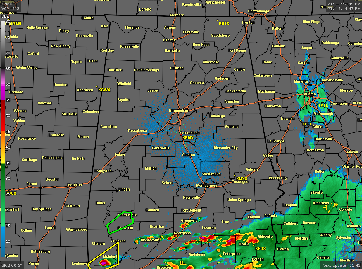
At 12:45 pm, all of North/Central Alabama is rain-free at this point with the exception of the far southern parts of Pike and Barbour counties. As a matter of fact, there is a good bit of sunshine across the central portions of the area. The bad news is that sunshine is helping the instability to build across the area, ranging from 500-2500 J/kg along and south of the I-20/59 corridor. We are still expecting for some showers and thunderstorms to develop during the afternoon and early evening hours.
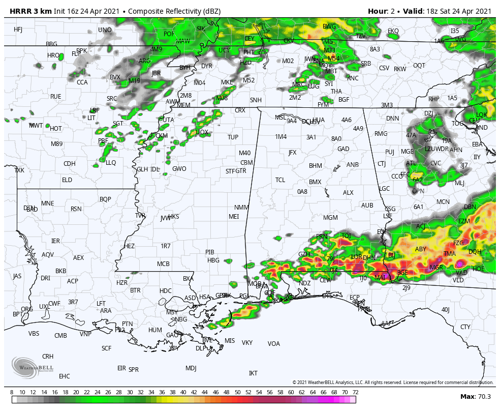
The 16z run of the HRRR still has more rain and thunderstorms developing over the southern parts of the state, including the extreme southern and southeastern parts of Central Alabama. We also note that a cluster of storms may form over northern Mississippi and move across the northern half of North/Central Alabama during the afternoon and evening hours. All of the activity will be out of the area before midnight tonight.
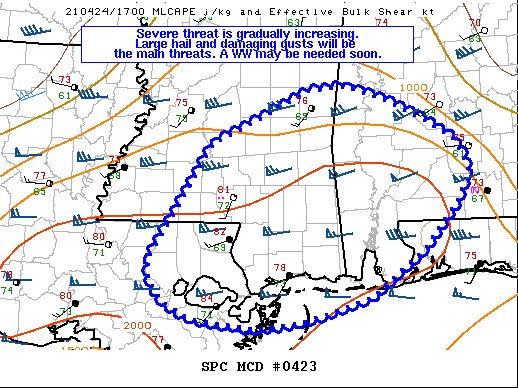
The SPC just released a mesoscale discussion for the southwestern parts of Alabama, including the extreme southwestern parts of Central Alabama, for the threat of severe storms is gradually increasing. Large hail and damaging wind gusts will be the main threats. A Severe Thunderstorm Watch may be needed as odds for one is around 60% at this time.
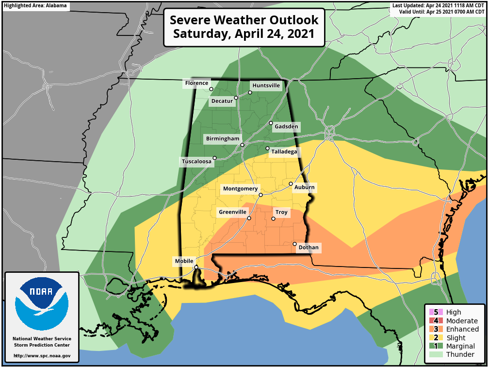
The SPC has also updated the Day 1 Severe Weather Outlook and the Enhanced and Slight Risk area have shrunk in size, while the Marginal Risk has expanded. The Enhanced Risk now covers the extreme south and southeastern parts of Central Alabama including Fort Deposit, Troy, and Eufaula. The Slight Risk stretches north and west of that and includes Demopolis, Selma, Clanton, Montgomery, Alexander City, and Auburn. The Marginal Risk includes nearly all of the rest of North/Central Alabama including Hamilton, Tuscaloosa, Birmingham, Gadsden, Anniston, Russellville, Decatur, Athens, Hartselle, Cullman, Huntsville, Guntersville, Scottsboro, and Rainsville.
Damaging wind gusts up to 60 mph and hail up to quarter size in diameter are the main threats across the risk areas, but we cannot rule out a brief spin-up tornado or two. The severe threat continues in the Marginal and Slight Risk locations by 7 pm this evening, and in the Enhanced Risk area by 9 pm tonight.
Category: Alabama's Weather, ALL POSTS, Severe Weather
About the Author (Author Profile)
Scott Martin is an operational meteorologist, professional graphic artist, musician, husband, and father. Not only is Scott a member of the National Weather Association, but he is also the Central Alabama Chapter of the NWA president. Scott is also the co-founder of Racecast Weather, which provides forecasts for many racing series across the USA. He also supplies forecasts for the BassMaster Elite Series events including the BassMaster Classic.Subscribe
If you enjoyed this article, subscribe to receive more just like it.


