Severe Threat Continues for Severe Thunderstorm Watch Area in Southeastern Parts of Central Alabama
Latest Mesoscale Discussion:
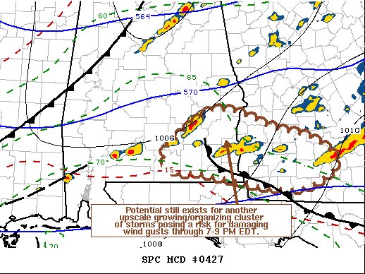
SUMMARY… Potential still exists for the evolution of another upscale growing and organizing cluster of storms which could pose increasing risk for damaging wind gusts across parts of southeastern Alabama into southwestern Georgia through 7-9 PM EDT.
DISCUSSION… Lift aided by low-level convergence along a pre-cold frontal wind shift advancing across southern Alabama, and warm advection along a sharp, quasi-stationary, convectively reinforced surface front across southwestern/southern Georgia, is maintaining vigorous new thunderstorm development. This appears to be occurring in the presence of moderate to large CAPE on the order of 1000-2000+ J/kg, and strong deep-layer shear beneath 50-70 kt west-southwesterly flow around 500 mb. Low-level shear also remains rather strong, with 40 kt southwesterly flow around 850 mb roughly aligned with the wind shift.
Given this environment, the surface boundary intersection east of Troy, AL into the Albany, GA vicinity might provide a focus for consolidating, upscale growing convection during the next few hours. If this occurs, the evolution of an organizing convective system capable of producing damaging wind gusts could still evolve through early evening.
Category: Alabama's Weather, ALL POSTS, Severe Weather
About the Author (Author Profile)
Scott Martin is an operational meteorologist, professional graphic artist, musician, husband, and father. Not only is Scott a member of the National Weather Association, but he is also the Central Alabama Chapter of the NWA president. Scott is also the co-founder of Racecast Weather, which provides forecasts for many racing series across the USA. He also supplies forecasts for the BassMaster Elite Series events including the BassMaster Classic.Subscribe
If you enjoyed this article, subscribe to receive more just like it.


