Drier Air Drops Into North/Central Alabama Today
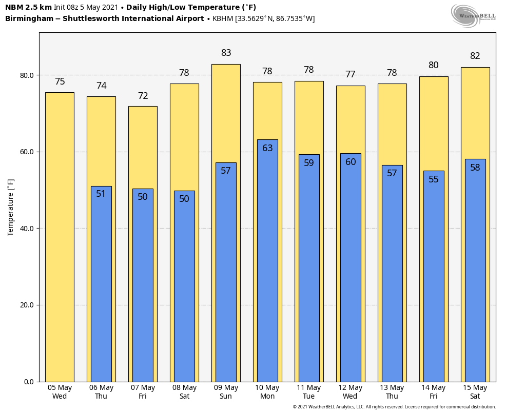
RADAR CHECK: Showers and storms are confined to far South Alabama and the Florida Panhandle early this morning where a flash flood watch remains in effect. The northern 2/3 of the state is getting a break from the rain as drier air has arrived. For North/Central Alabama, we expect morning clouds to give way to a partly sunny afternoon… the high today will be in the mid 70s for most places. The average high for Birmingham on May 5 is 80.
Tomorrow will be dry during the day; with a good supply of sunshine the high will be back in the mid 70s. Then, a secondary cold front will push into the state tomorrow night. This front could squeeze out a few scattered showers over North Alabama tomorrow night, but moisture will be limited, and rain amounts will be very light and spotty.
Then, Friday will be sunny and cool for early May with a high only in the 68-72 degree range.
THE ALABAMA WEEKEND: Saturday will be another mostly sunny day with a high around 80 degrees. Clouds will begin to increase Sunday, and showers could reach some of the western and northern counties by mid to late afternoon. Showers and storms are more likely, mainly over the northern half of the state, by Sunday night. Sunday’s high will be in the low 80s.
NEXT WEEK: The first half of the week is looking wet at times and unsettled; we will forecast a good chance of showers and thunderstorms Monday through Wednesday with highs generally in the 77-80 degree range. Then, the weather trends drier by Thursday and Friday… See the Weather Xtreme video for maps, graphics, and more details.
RAIN TOTALS: Some remarkable rain totals across Alabama yesterday… these are from the ABC 33/40 Skywatcher team….
West Blocton 6.70”
Moody 6.68”
Vestavia Hills 6.20”
Mountain Brook 5.87”
Bessemer 5.15”
Crestwood 5.08”
Hoover 4.82”
Margaret 4.68”
Rainbow City 4.59”
Bibbville 4.28”
Weaver 4.21”
Gardendale 4.20”
Rock Creek 4.02”
Oak Grove 3.84”
Remap 3.78”
Northport 3.42”
Carbon Hill 3.38”
Rainbow City 3.27”
Hueytown 3.22”
ON THIS DATE IN 1933: Two devastating tornadoes were responsible for 25 deaths and 227 injuries in Central Alabama in the predawn hours of May 5, 1933.
The first was an F3 tornado which touched down at 12:20 a.m. and moved through Choctaw, Sumter, and Marengo counties, killing four and injuring 27 people along its 35 mile long path. Three of the fatalities occurred at Demopolis in Marengo County where 50 homes were destroyed. The second tornado touched down around 2:30 a.m. and moved through Bibb and Shelby counties along a 35 mile long path. This tornado had damage consistent with an F4 rating and was responsible for 21 deaths and 200 injuries. Hardest hit was the Shelby County town of Helena. There 14 were killed and 150 were injured. Five were killed in Brent in Bibb County and one was killed in the Colemont community.
BEACH FORECAST: Click here to see the AlabamaWx Beach Forecast Center page.
WEATHER BRAINS: Don’t forget you can listen to our weekly 90 minute show anytime on your favorite podcast app. This is the show all about weather featuring many familiar voices, including our meteorologists here at ABC 33/40.
CONNECT: You can find me on all of the major social networks…
Look for the next Weather Xtreme video here by 3:00 this afternoon… enjoy the day!
Category: Alabama's Weather, ALL POSTS, Weather Xtreme Videos
About the Author (Author Profile)
James Spann is one of the most recognized and trusted television meteorologists in the industry. He holds the AMS CCM designation and television seals from the AMS and NWA. He is a past winner of the Broadcast Meteorologist of the Year from both professional organizations.Subscribe
If you enjoyed this article, subscribe to receive more just like it.


