No Rain Through Early Next Week; Heat Levels Rising
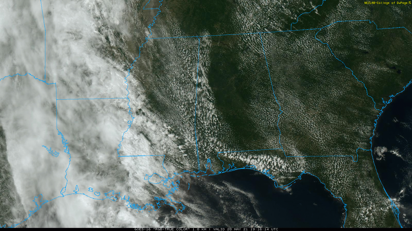
SUNNY MAY DAYS: A strong upper high over the eastern third of the U.S. will keep Alabama’s weather rain-free through the weekend. With a mostly sunny sky this afternoon, temperatures are mostly in the low to mid 80s, very close to seasonal averages. Gusty east/southeast winds continue across the state due to a tight pressure gradient; they will die down after sunset. Tonight will be mostly fair with a low in the 60s.
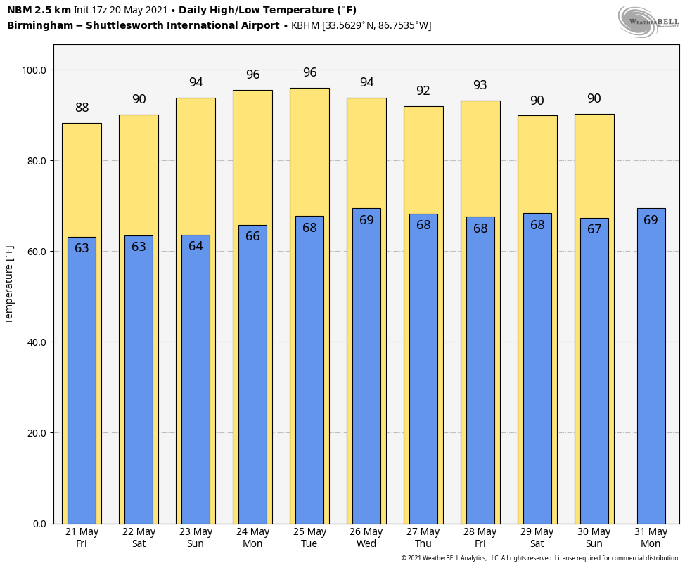
Heat levels will rise tomorrow through the weekend with sunny days and fair nights. The high tomorrow will be in the 84-89 degree range, and most communities should reach 90 degrees for the first time this year Saturday. Low 90s are likely Sunday.
NEXT WEEK: Afternoon highs will be in the mid 90s early next week, very close to record levels. Here are the daily record highs for Birmingham…
May 24 (Monday) 96 (1996)
May 25 (Tuesday) 95 (1962)
May 26 (Wednesday) 97 (1962)
In addition to being hot, the weather will be dry for the first half of the week. The upper ridge weakens a bit Thursday and Friday, and a few isolated showers could show up, but nothing widespread. See the Weather Xtreme video for maps, graphics, and more details.
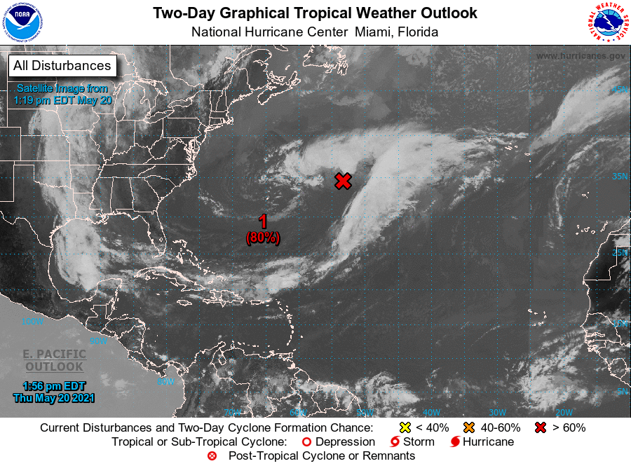
TROPICS: A non-tropical low pressure system located about 650 miles east-northeast of Bermuda is now moving northward, and recent satellite wind data indicate that the system has gale-force winds. The low is expected to turn westward and west-southwestward over warmer waters tonight and tomorrow, and it will likely become a subtropical cyclone near and to the northeast of Bermuda tomorrow. After that time, the system is expected to move toward the north and northeast into a more hostile environment by late Sunday into Monday. The name will be “Ana”. There are no systems near the U.S.
ON THIS DATE IN 1957: A tornado touched down to the southwest of Kansas City and traveled a distance of seventy-one miles cutting a swath of near destruction through the southeastern suburbs of Ruskin Heights and Hickman Mills. The tornado claimed the lives of forty-five persons and left hundreds homeless. It was the worst weather disaster on record for Kansas City. About all that remained of one house were a small table and a fishbowl atop, with the fish still swimming about inside the bowl. A canceled check from Hickman Hills was found in Ottumwa, Iowa, 165 miles away. Pilots reported debris at an altitude of 30,000 feet.
ON THIS DATE IN 2013: A large and extremely powerful EF-5 tornado ravaged Moore, Oklahoma, and adjacent areas, with peak winds estimated at 210 mph, killing 24 people and injuring 212 others. The tornado was part of a larger weather system that had produced several other tornadoes across the Great Plains over the previous two days, including five that struck portions of Central Oklahoma the day prior on May 19. There has not been an EF-5 tornado in the U.S. since this event.
BEACH FORECAST: Click here to see the AlabamaWx Beach Forecast Center page.
WEATHER BRAINS: Don’t forget you can listen to our weekly 90 minute show anytime on your favorite podcast app. This is the show all about weather featuring many familiar voices, including our meteorologists here at ABC 33/40.
CONNECT: You can find me on all of the major social networks…
Look for the next Weather Xtreme video here by 6:00 a.m. tomorrow…
Category: Alabama's Weather, ALL POSTS, Weather Xtreme Videos
About the Author (Author Profile)
James Spann is one of the most recognized and trusted television meteorologists in the industry. He holds the AMS CCM designation and television seals from the AMS and NWA. He is a past winner of the Broadcast Meteorologist of the Year from both professional organizations.Subscribe
If you enjoyed this article, subscribe to receive more just like it.


