Hot, Dry Weather Continues Across Alabama
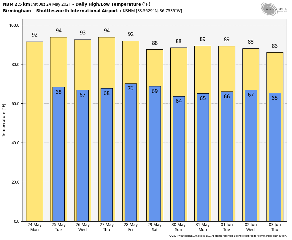
MAY HEAT: Yesterday, many cities experienced 90 degrees for the first time this year, including Birmingham, Huntsville, and Montgomery. The weather won’t change much today through Wednesday… mostly sunny hot days and fair nights. Afternoon highs will be generally in the 90-93 degree range; the average high for Birmingham on May 24 is 84.
The upper high, responsible for the hot, dry weather, will break down a bit later in the week, and we will introduce the chance of isolated showers or storms during the afternoon and evening hours over the northern half of the state. Nothing widespread, and most places will stay dry due to the isolated nature of the showers. Highs Thursday and Friday afternoon will be between 88 and 92 degrees.
THE ALABAMA WEEKEND: We are forecasting a partly sunny sky Saturday and Sunday, and again we will mention “widely scattered, mostly afternoon and evening showers and thunderstorms” in the forecast. The chance of any one spot getting wet both days will be in the 20-25 percent range, and highs will be generally in the upper 80s.
NEXT WEEK: The American global model (the GFS) is advertising a pattern change, with the ridge shifting to the western U.S.; this could give us a good chance of rain by mid-week with cooler temperatures. But the reliable European global model (ECMWF) keeps the ridge over southern states, and most likely that is the correct solution. So, we will go with a persistence forecast next week with partly sunny days and only isolated or widely scattered afternoon showers. Highs will be in the upper 80s most days… See the Weather Xtreme video for maps, graphics, and more details.
AIR QUALITY ALERT: A “code orange” air quality alert has been issued for today for the Birmingham metro; air quality is expected to be unhealthy for sensitive groups… people with respiratory problems or asthma.
SUNDAY’S HEAT: Here are some highs across Alabama yesterday:
Mobile 87
Hueytown 88
Oneonta 89
Coker 89
Parrish 89
Huntsville 90
Anniston 90
Gadsden 90
Birmingham 90
Haleyville 90
Clanton 90
Dothan 90
West Blocton 90
Cedar Bluff 90
Lay Lake 90
Muscle Shoals 91
Eufaula 91
Tuscaloosa 91
Troy 92
Pell City 92
Weaver 93
ON THIS DATE IN 1973: An F4 tornado tore through the small town of Union City, Oklahoma, killing two and injuring four others. This tornado was the first storm to be studied in detail by the National Severe Storms Laboratory Doppler Radar Unit at Norman, OK and an armada of researchers in the field. Research of the radar data from the storm would lead to the discovery of a “TVS,” or Tornado Vortex Signature.
ON THIS DATE IN 2011: A tornado outbreak occurred over parts of northern and central Oklahoma during the day on May 24, 2011, with violent tornadoes devastating several communities. By the end of the day, one EF-5, two EF-4, and two EF-3 tornadoes destroyed buildings, ripped up trees and power poles, and unfortunately, resulted in 11 deaths and 293 injuries.
BEACH FORECAST: Click here to see the AlabamaWx Beach Forecast Center page.
WEATHER BRAINS: Don’t forget you can listen to our weekly 90 minute show anytime on your favorite podcast app. This is the show all about weather featuring many familiar voices, including our meteorologists here at ABC 33/40.
CONNECT: You can find me on all of the major social networks…
Look for the next Weather Xtreme video here by 3:00 this afternoon… enjoy the day!
Category: Alabama's Weather, ALL POSTS, Weather Xtreme Videos
About the Author (Author Profile)
James Spann is one of the most recognized and trusted television meteorologists in the industry. He holds the AMS CCM designation and television seals from the AMS and NWA. He is a past winner of the Broadcast Meteorologist of the Year from both professional organizations.Subscribe
If you enjoyed this article, subscribe to receive more just like it.


