Hot, Dry Again Today; Showers Possible Late This Week
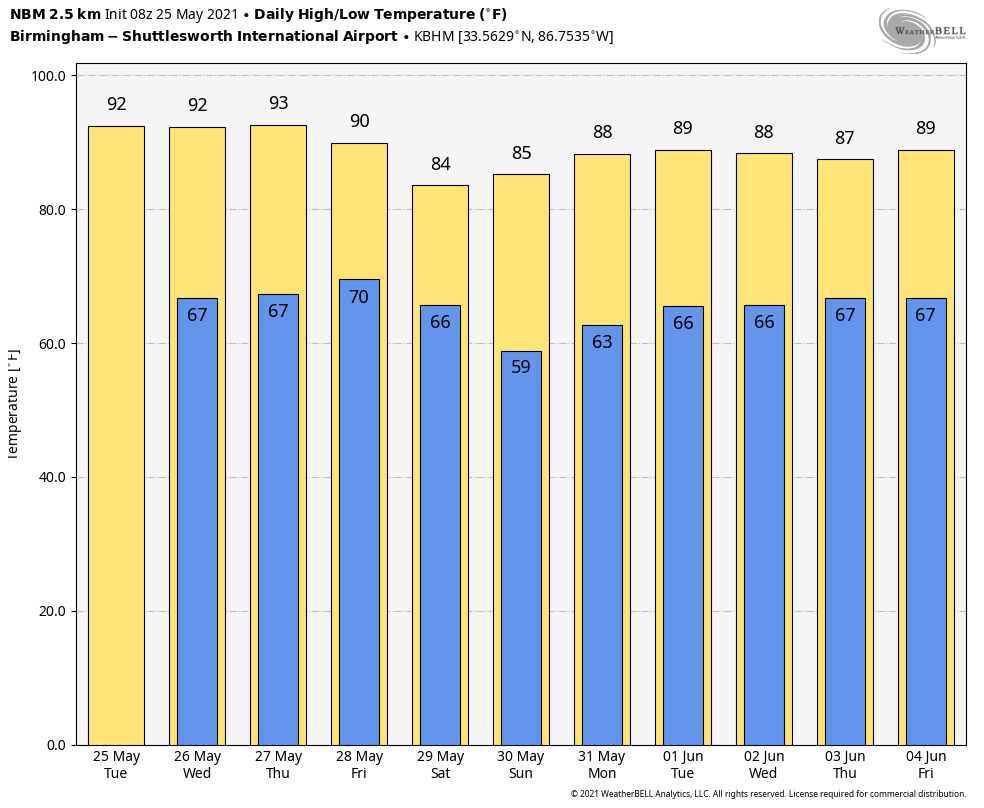
NEW DAY, OLD FORECAST: Today for Birmingham, and most other communities across North/Central Alabama, will be the 13th consecutive day without measurable rain. The sky will be partly to mostly sunny with a high in the low 90s… the average high for May 25 at Birmingham is 84.
Not much change tomorrow… most of the state will be dry, although a few isolated showers could creep into the far northwest part of the state during the afternoon and evening hours.
THURSDAY/FRIDAY: We will bring in the chance of a few isolated afternoon showers Thursday over the northern third of the state as the upper high overhead weakens a bit; chance of any one spot getting wet across North/Central Alabama is only one in five, and the high will be in the 88-92 degree range. It now looks like we will have a better chance of showers and thunderstorms over the northern half of the state Friday afternoon and Friday evening as a weak surface cold front pushes into North Alabama. Rain amounts will be under 1/4 inch for most places, not really enough to make a big dent in this dry spell, but at least it will get some water into the ground in many areas. Friday’s high will be in the upper 80s.
THE ALABAMA WEEKEND: Drier air works into the northern half of the state Saturday, and it looks like any isolated showers will be over the southern counties. Heat levels come down; the high will be in the mid 80s with lower humidity levels over North Alabama. Sunday looks mostly dry with only a small risk of a shower along with a high in the mid to upper 80s.
NEXT WEEK: The week looks generally quiet with only potential for a few isolated showers; the two main global models have backed off the idea of an eastern U.S. trough and increased rain coverage over the latter half of the week. High will be mostly in the upper 80s… See the Weather Xtreme video for maps, graphics, and more details.
SEC BASEBALL: The weather will stay hot and mostly dry in Hoover through Thursday with highs in the 89-92 degree range daily. There will be some risk of a passing shower or thunderstorm Friday afternoon and Friday evening, then the weekend looks dry with highs in the mid to upper 80s.
TROPICS: All is quiet across the Atlantic basin; the official start to the Atlantic hurricane season is one week from today.
ON THIS DATE IN 2008: A rare, large and destructive EF5 tornado created a 43-mile long path across Butler and Black Hawk counties in Iowa. This tornado killed eight people, injured dozens and caused several millions of dollars in damage. The tornado was nearly three-quarters of a mile wide as it moved through the southern end of Parkersburg. A third of the town was affected by devastating damage with nearly 200 homes destroyed.
BEACH FORECAST: Click here to see the AlabamaWx Beach Forecast Center page.
WEATHER BRAINS: Don’t forget you can listen to our weekly 90 minute show anytime on your favorite podcast app. This is the show all about weather featuring many familiar voices, including our meteorologists here at ABC 33/40.
CONNECT: You can find me on all of the major social networks…
Look for the next Weather Xtreme video here by 3:00 this afternoon… enjoy the day!
Category: Alabama's Weather, ALL POSTS, Weather Xtreme Videos
About the Author (Author Profile)
James Spann is one of the most recognized and trusted television meteorologists in the industry. He holds the AMS CCM designation and television seals from the AMS and NWA. He is a past winner of the Broadcast Meteorologist of the Year from both professional organizations.Subscribe
If you enjoyed this article, subscribe to receive more just like it.


