Scattered Storms Ending Later Tonight; Warm, Humid Days Ahead
RADAR CHECK: Scattered showers and storms continue to increase over West Alabama this afternoon… some of them are strong with frequent lightning, heavy rain, and gusty winds. SPC maintains a “marginal risk” of severe thunderstorms west of a line from Huntsville to Tuscaloosa to Butler through the evening hours.
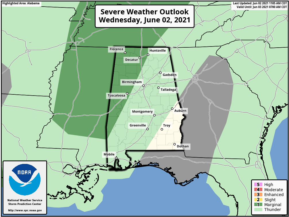
Away from the storms we have a mix of sun and clouds with temperatures in the 78-84 degree range. Scattered showers and storms will fade away later tonight after sunset.
Tomorrow will be another warm, humid day with some sun, and once again developing showers and thunderstorms in random, scattered spots. The heavier storms tomorrow will likely be found over Northeast Alabama, where SPC has a “marginal risk” defined. Like today, heavier storms will produce frequent lightning, heavy rain, and gusty winds.
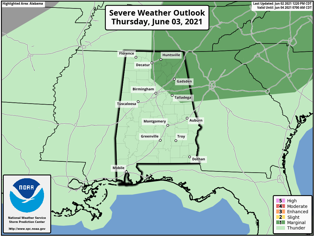
Otherwise, tomorrow will be partly sunny with a high in the mid 80s.
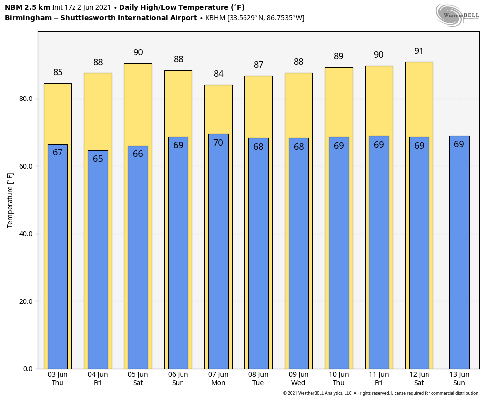
FRIDAY AND THE WEEKEND: Precipitable water values will decrease across Alabama Friday and Saturday, meaning a good supply of sunshine both days with very few showers around. Afternoon highs will be in the upper 80s for most locations. Then, on Sunday, we are forecasting a partly sunny sky with a few scattered afternoon showers or thunderstorms possible… the high Sunday will be in the 84-88 degree range.
NEXT WEEK: The week will feature very routine weather for June in Alabama. Partly sunny, warm, humid days with the daily round of random, scattered showers and thunderstorms. Odds of any one spot getting wet each day will be in the 35-55 percent range, with highs in the 80s. See the Weather Xtreme video for maps, graphics, and more details.
TROPICS: The Atlantic basin remains quiet, and tropical storm formation is not expected through the weekend.
ON THIS DATE IN 1998: A major tornado outbreak for the east-central United States. This severe weather event spawned a total of 47 tornadoes over 9 states from New York to South Carolina and caused an estimated $42 million in damage, 80 injuries and 2 fatalities. The most violent tornado hit Frostburg, Maryland, in Allegany County, at 9:43 PM ET. Five persons were injured, and $5 million in property damage was reported. It was the first F4 tornado to have hit the state of Maryland since the National Weather Service began keeping records in 1950.
BEACH FORECAST: Click here to see the AlabamaWx Beach Forecast Center page.
WEATHER BRAINS: Don’t forget you can listen to our weekly 90 minute show anytime on your favorite podcast app. This is the show all about weather featuring many familiar voices, including our meteorologists here at ABC 33/40.
CONNECT: You can find me on all of the major social networks…
Look for the next Weather Xtreme video here by 6:00 a.m. tomorrow…
Category: Alabama's Weather, ALL POSTS, Weather Xtreme Videos
About the Author (Author Profile)
James Spann is one of the most recognized and trusted television meteorologists in the industry. He holds the AMS CCM designation and television seals from the AMS and NWA. He is a past winner of the Broadcast Meteorologist of the Year from both professional organizations.Subscribe
If you enjoyed this article, subscribe to receive more just like it.


