Dry Today; Tropical Rain Over The Weekend
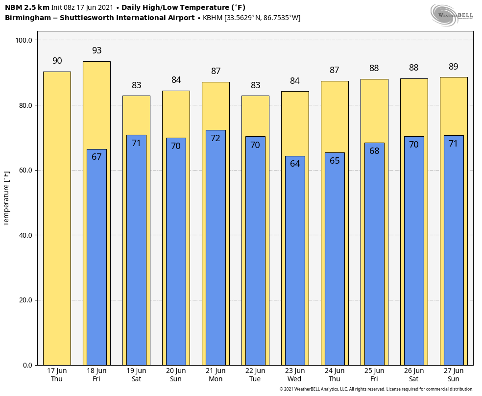
DRY AGAIN TODAY: Temperatures are in the 58-64 degree range across much of Alabama early this morning, we expect another mostly sunny day ahead with a high around 90 degrees this afternoon. The average high for Birmingham on June 17 is 89.
The northern 2/3 of the state will stay dry tomorrow with a high in the low 90s, but a tropical system in the Gulf of Mexico will bring rain into the southwest corner of the state by afternoon.
SATURDAY THROUGH MONDAY: A tropical low will move through the region, bringing a statewide soaking over the weekend. Rain over South Alabama Friday night will expand northward Saturday morning, and most of the state will be in rain by Saturday afternoon and evening. Rain continues Saturday night and Sunday, and the rain could be heavy at times. The tropical low will move northeast of Alabama by Sunday evening, but very deep moisture will be left behind, and periods of rain will continue Sunday night into Monday.
Rain amounts for much of Alabama tomorrow through Monday will be in the 3-6 inch range, with potential for heavier totals in spots, especially over the southwest counties. Some flooding is very possible over the weekend.
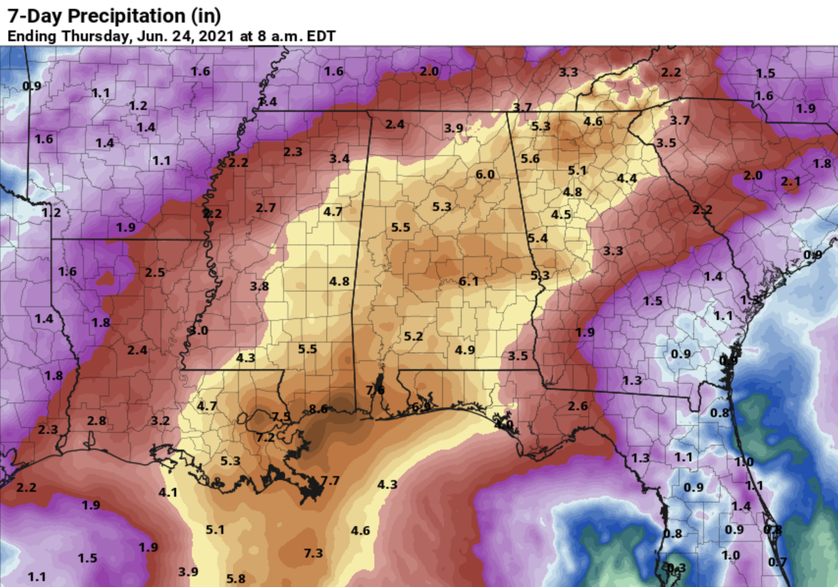
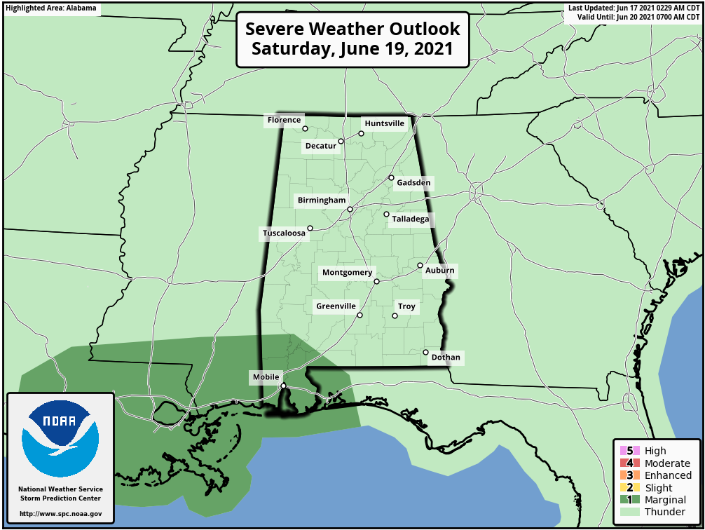
A few brief, isolated tornadoes will be possible Saturday afternoon, Saturday night, and early Sunday over South Alabama; SPC has defined a “marginal risk” (level 1/5) for the southwest corner of the state. This could be expanded later as the tropical system evolves.
REST OF NEXT WEEK: The chance of rain, along with a few thunderstorms, will remain fairly high on Tuesday as a cold front approaches. Then, the weather trends drier over the latter half of the week. Highs will be in the mid to upper 80s most days… See the Weather Xtreme video for maps, graphics, and more details.
TROPICS: The broad low pressure area located over the eastern portion of the Bay of Campeche is producing widespread cloudiness and disorganized showers and a few thunderstorms. This system will move little today, and little if any development is expected during that time due to interaction with land and unfavorable upper-level winds. However, the low should begin to move northward by this afternoon, and a tropical or subtropical depression is likely to form by late tonight or tomorrow when the low moves across the western Gulf of Mexico. An Air Force Reserve Unit reconnaissance aircraft is scheduled to investigate the disturbance this afternoon, if necessary.
This is the feature that will bring a soaking rain to the Deep South this weekend. Keep in mind the rip current danger will be high along the Gulf Coast tomorrow through Sunday, and some coastal flooding is possible.
The rest of the Atlantic basin is quiet.
ON THIS DATE IN 1946: The third deadliest tornado in Canadian history struck southwestern Ontario from Windsor to Tecumseh. 17 people were killed and hundreds injured. Damage was conservatively estimated at $1.5 million.
BEACH FORECAST: Click here to see the AlabamaWx Beach Forecast Center page.
WEATHER BRAINS: Don’t forget you can listen to our weekly 90 minute show anytime on your favorite podcast app. This is the show all about weather featuring many familiar voices, including our meteorologists here at ABC 33/40.
CONNECT: You can find me on all of the major social networks…
Look for the next Weather Xtreme video here by 3:00 this afternoon… enjoy the day!
Category: Alabama's Weather, ALL POSTS, Weather Xtreme Videos
About the Author (Author Profile)
James Spann is one of the most recognized and trusted television meteorologists in the industry. He holds the AMS CCM designation and television seals from the AMS and NWA. He is a past winner of the Broadcast Meteorologist of the Year from both professional organizations.Subscribe
If you enjoyed this article, subscribe to receive more just like it.


