Occasional Showers Today; Beautiful Holiday Weekend Ahead
RADAR CHECK: We have large areas of light to moderate rain moving across Alabama this morning ahead of a rare July cold front just to the north. Today will be mostly cloudy with periods of rain and possibly a thunderstorm or two… temperatures will likely hold in the 70s all day due to clouds and rain. The average high for Birmingham on July 2 is 90. Showers will end from north to south this evening as dry air begins to roll in.
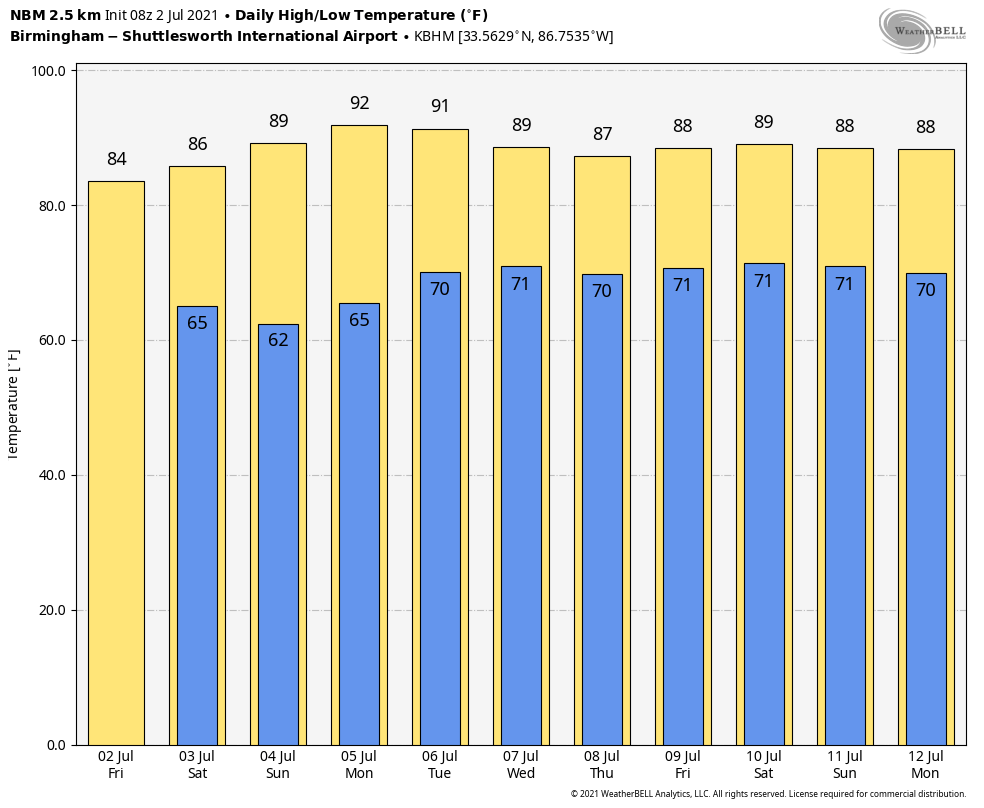
FOURTH OF JULY WEEKEND: Dry air will cover the northern 2/3 of the state; we expect mostly sunny days, cooler nights, and lower humidity tomorrow through Monday. Highs will be in the 80s, and many places over North/Central Alabama could dip into the cool 50s early Sunday morning. A few scattered showers and storms will remain possible over far South Alabama and along the Gulf Coast over the weekend, but no “washout”, and there will be some sun at times.
NEXT WEEK: Moisture will slowly return, and we will bring back the risk of scattered showers and storms over the latter half of the week statewide. For now it looks like any impact from the tropical system will remain east of Alabama… highs will be in the 87-91 degree range most days. See the Weather Xtreme video for maps, graphics, and more details.
TROPICAL STORM ELSA: Elsa continues to grow stronger as it approaches the Windward Islands; winds are now 60 mph. The tropical storm is moving along at a very quick pace; it is moving west/northwest at 28 mph. This fast forward motion will limit the ability of the system to strengthen more over the next few days. The NHC forecast track brings Elsa across Cuba Sunday, and to a point north of Tampa Bay, over the Florida peninsula, by Tuesday night of next week.
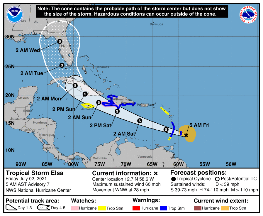
As stated here through the week, this forecast can, and probably will change over the next few days. The average five day NHC track error is around 200 miles. While it certainly looks like the Florida peninsula will be impact by Elsa, you simply can’t define those impacts this far out. Odds are increasing that Alabama and the Central Gulf Coast (Gulf Shores, Pensacola, Destin, Panama City Beach) will be on the “good” west side of the system.
NHC keeps the system under hurricane strength over the next five days; the fast forward speed of the storm and associated mid-level wind shear should prevent significant intensification.
The rest of the Atlantic basin is quiet.
ON THIS DATE IN 2001: In Michigan, frost and freezing temperatures were observed in some locations with Grant dropping to 29 degrees. Muskegon reported their coldest July temperature on record with 39 degrees. Other daily record lows included: Lansing: 38, Muskegon: 39, Flint: 40, Youngstown, Ohio: 40, and Grand Rapids, Michigan: 43 degrees.
BEACH FORECAST: Click here to see the AlabamaWx Beach Forecast Center page.
WEATHER BRAINS: Don’t forget you can listen to our weekly 90 minute show anytime on your favorite podcast app. This is the show all about weather featuring many familiar voices, including our meteorologists here at ABC 33/40.
CONNECT: You can find me on all of the major social networks…
Look for the next Weather Xtreme video here by 3:00 this afternoon… enjoy the day!
Category: Alabama's Weather, ALL POSTS, Weather Xtreme Videos
About the Author (Author Profile)
James Spann is one of the most recognized and trusted television meteorologists in the industry. He holds the AMS CCM designation and television seals from the AMS and NWA. He is a past winner of the Broadcast Meteorologist of the Year from both professional organizations.Subscribe
If you enjoyed this article, subscribe to receive more just like it.


