

Midday Nowcast: Wet is the Word
An upper level trough and a meandering surface front means the work week has started off wet for much of Alabama. Today is featuring more clouds than sun with widespread and numerous showers and storms. Rain is possible at any time, while thunderstorms are more common during the afternoon and evening hours.

Expect lots of lightning with any storms and heavy rainfall will be common which could lead to some areas of flash flooding. On average, rainfall totals these two days will be in the 1-3” range, with isolated higher amounts. Due to the clouds and rain, temperatures will hold in the upper 70s to low 80s. Not much change in the forecast for tomorrow.
FLASH FLOOD WATCH: The NWS in Huntsville has placed much of the Tennessee Valley of under a flash flood watch in effect through Tuesday morning. Numerous showers and a few thunderstorms are expected today along a stationary front with widespread rainfall totals of 1 to 2 inches and isolated totals up to 4 to 5 inches.
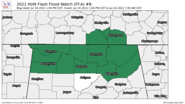
Heavy rain last weekend has saturated soils, and rain rates will likely exceed absorption rates, leading to potential flash flooding. It is not out of the question that watches could be expanded elsewhere across Alabama as well. Just remember to TURN AROUND, DON’T DROWN, if you come across flood waters.
REST OF THE WEEK: The trough lifts out of the area by Wednesday, but tropical air will remain in place, so rain chances will be a tad lower, but still each day will feature scattered to perhaps numerous showers and storms. Rain chances Wednesday through Friday look to be in the 40-60% range. Expect partly sunny days with highs in the mid to upper 80s, which remain below average for July in Alabama.
IN THE TROPICS: For the North Atlantic, Caribbean Sea, and the Gulf of Mexico: Tropical cyclone formation is not expected this week as there are no areas of interest.

BEACH FORECAST CENTER: Get the latest weather and rip current forecasts for the beaches from Fort Morgan to Panama City on our Beach Forecast Center page. There, you can select the forecast of the region that you are interested in visiting.
WORLD TEMPERATURE EXTREMES: Over the last 24 hours, the highest observation outside the U.S. was 121.8F at Adrar, Algeria. The lowest observation was -87.9F at Ago-4, Antarctica.
CONTIGUOUS TEMPERATURE EXTREMES: Over the last 24 hours, the highest observation was 117F at Death Valley, CA. The lowest observation was 34F at Peter Sinks, UT.
Category: Alabama's Weather, ALL POSTS
About the Author (Author Profile)
Macon, Georgia Television Chief Meteorologist, Birmingham native, and long time Contributor on AlabamaWX. Stormchaser. I did not choose Weather, it chose Me. College Football Fanatic. @Ryan_StinnetSubscribe
If you enjoyed this article, subscribe to receive more just like it.


