Midday Nowcast: Heat Advisory and Waiting on Fred
Pretty routine August weather for Alabama this week. The days continue to feature a mix of sun and clouds while afternoon temperatures climb into the low and mid 90s.
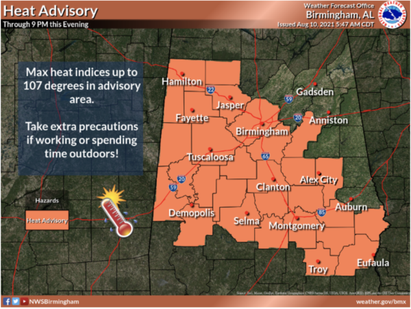
Heat index values will easily be over 100°, and could climb over 105° at times, which is advisory criteria for Central Alabama. Therefore a Heat Advisory has been issued for much of Central Alabama until 9PM this evening. We are likely to see additional heat advisories in the coming days for parts of the state as well.
As far as heat relief, it will come from showers and storms that pop-up on the radar each day, especially during the afternoon and evening hours, and these will be randomly scattered about the Alabama landscape. Most of the showers and storms will come from 1PM-11PM daily with the odds of any one spot getting wet reach day are in the 35-55 percent range. As we approach the midday hours, showers and storms are developing across Central Alabama, specifically around the Birmingham Metro, and these will continue to increase in coverage through the afternoon hours.
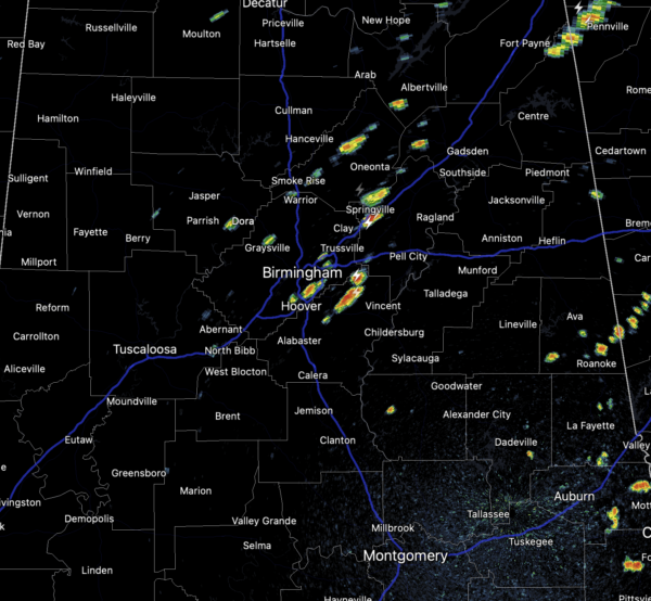
Some storms could be strong at times with gusty winds and tremendous amounts of lightning. Also, some locations will see a soaking, which could cause some isolated flash flooding, but just down the road it will be dry. Again, these storms are completely random, and you just have to watch radar trends when they start developing.
WAITING ON FRED: Latest update on Potential Tropical Cyclone Six – the disturbance was centered near latitude 16.3 North, longitude 63.8 West. The system is moving toward the west-northwest near 18 mph and this general motion is expected to continue during the next few days. On the forecast track, the disturbance is expected to pass near or over the U.S. Virgin Islands and Puerto Rico later today and tonight, be near or over Hispaniola on Wednesday, and be near the southeastern Bahamas and the Turks and Caicos Islands Thursday.
Reports from a NOAA Hurricane Hunter aircraft indicate that maximum sustained winds are near 35 mph with higher gusts. However, the aircraft did not find a well-defined closed circulation. Gradual strengthening is forecast during the next day or so and the disturbance is expected to become a tropical storm later today or tonight. Some weakening is likely while the system interacts with mountains of Hispaniola on Wednesday. The estimated minimum central pressure is 1012 mb (29.89 inches).
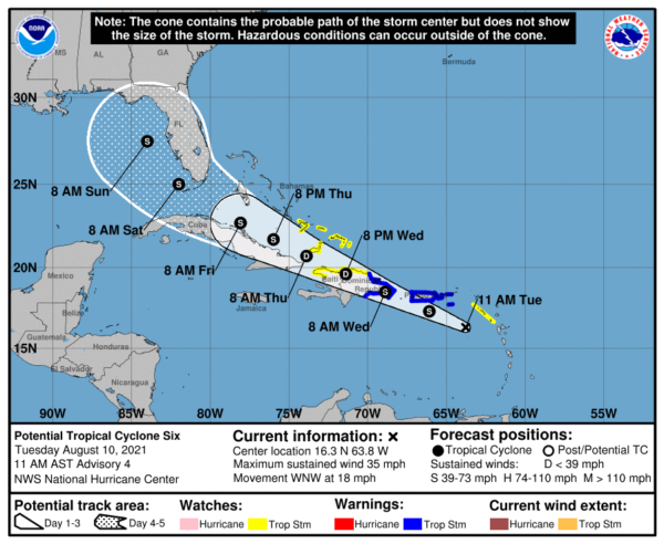
From there, long range modeling suggests there could be a potential landfall over the eastern Florida panhandle in six days (Monday of next week). But this system has not even developed a core, and there is no way of knowing now the ultimate destination or intensity. If you have a beach trip planned next week, I would not cancel or make any changes; just keep an eye on the system.
BEACH FORECAST CENTER: Get the latest weather and rip current forecasts for the beaches from Fort Morgan to Panama City on our Beach Forecast Center page. There, you can select the forecast of the region that you are interested in visiting.
WORLD TEMPERATURE EXTREMES: Over the last 24 hours, the highest observation outside the U.S. was 120.9F at Jahra, Kuwait. The lowest observation was -108.2F at University Dome, Antarctica.
CONTIGUOUS TEMPERATURE EXTREMES: Over the last 24 hours, the highest observation was 118F at Death Valley, CA. The lowest observation was 25F at Mackay, ID.
WEATHER ON THIS DATE IN 1882: Sandusky OH noted a four minute snow squall during the morning, frost was reported in the suburbs of Chicago, and a killing frost was reported at Cresco, IA.
Category: Alabama's Weather, ALL POSTS
About the Author (Author Profile)
Macon, Georgia Television Chief Meteorologist, Birmingham native, and long time Contributor on AlabamaWX. Stormchaser. I did not choose Weather, it chose Me. College Football Fanatic. @Ryan_StinnetSubscribe
If you enjoyed this article, subscribe to receive more just like it.


