

Hot, Mostly Dry Weather Through Wednesday
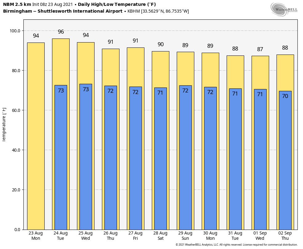
HEAT LEVELS RISING: An upper ridge will build across the Deep South for the first half of the week, setting the stage for some of the hottest weather so far this summer through Wednesday. We expect partly to mostly sunny days, fair nights, and only isolated showers and storms each day. The chance of any one spot getting wet is only 5 to 10 percent, and we project highs in the mid 90s, in the 93-96 degree range. The average high for August 23 at Birmingham is 91.
The ridge will weaken by Thursday and Friday, and scattered afternoon and evening showers and thunderstorms will become more active both days with a mix of sun and clouds. Heat levels also come down; highs will be in the upper 80s and low 90s.
THE ALABAMA WEEKEND: We expect some pretty typical late August weather; partly sunny Saturday and Sunday with “scattered, mostly afternoon and evening showers and thunderstorms” both days. Chance of any one spot seeing rain both days is 35-45 percent, and highs will be not too far from 90 degrees.
NEXT WEEK: We will stick with a persistence pattern for much of the week; partly sunny days with a few afternoon and evening showers and storms around on daily basis in scattered spots; highs will be mostly in the upper 80s. See the Weather Xtreme video for maps, graphics, and more details.
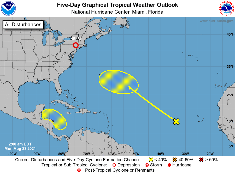
TROPICS: Tropical Storm Henri made landfall yesterday on the Rhode Island coast, and is dissipating this morning. Elsewhere, the Atlantic basin is relatively quiet. Disorganized shower activity over the eastern tropical Atlantic several hundred miles west of the Cabo Verde Islands is associated with a broad area of low pressure. Little, if any, development is expected to occur during the next couple of days. Some gradual development, however, is possible by the middle to latter part of the week as the system moves northwestward at 10 to 15 mph over the central Atlantic. For now the chance of development over the next five days is only 20 percent.
And, a broad area of low pressure is forecast to form over the western Caribbean Sea late this week. Environmental conditions are expected to be favorable for gradual development of this system thereafter while it moves west-northwestward over the northwestern Caribbean Sea. Long range models suggest this feature will move across the Yucatan peninsula, and into the Bay of Campeche, ultimately moving into the coast of Mexico far south of Brownsville, Texas in a week or so. But for now NHC gives this feature only a 20 percent chance of development.
ON THIS DATE IN 1933: A hurricane made landfall near Nags Head, North Carolina and tracked up the Chesapeake Bay. The Chesapeake-Potomac hurricane moved over Norfolk, Virginia, and Washington, DC. A seven-foot tide flooded businesses in Norfolk, Virginia. Described in the American Meteorological Society’s August 1933 weather review as “one of the most severe storms that have ever visited the Middle Atlantic Coast.”
ON THIS DATE IN 2005: Tropical Depression Twelve formed over the Southeast Bahamas as the result of the merger of a tropical wave and the remnants of Tropical Depression Ten four days earlier. It would go on to become Hurricane Katrina, one of the most deadly hurricanes (1,836 lives) in U.S. history.
BEACH FORECAST: Click here to see the AlabamaWx Beach Forecast Center page.
WEATHER BRAINS: Don’t forget you can listen to our weekly 90 minute show anytime on your favorite podcast app. This is the show all about weather featuring many familiar voices, including our meteorologists here at ABC 33/40.
CONNECT: You can find me on all of the major social networks…
Look for the next Weather Xtreme video here by 3:00 this afternoon… enjoy the day!
Category: Alabama's Weather, ALL POSTS, Weather Xtreme Videos
About the Author (Author Profile)
James Spann is one of the most recognized and trusted television meteorologists in the industry. He holds the AMS CCM designation and television seals from the AMS and NWA. He is a past winner of the Broadcast Meteorologist of the Year from both professional organizations.Subscribe
If you enjoyed this article, subscribe to receive more just like it.


