10 am Advisory — Ida Expected to Begin Rapid Intensification Soon
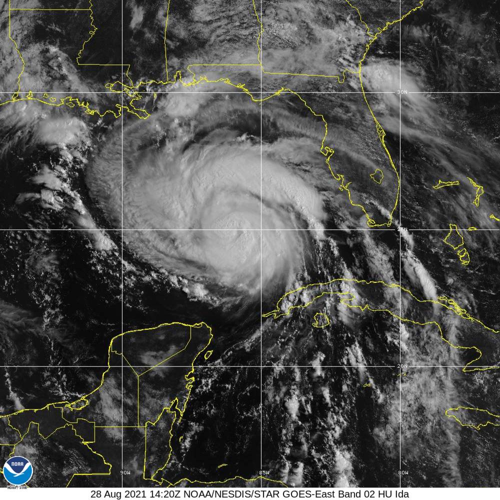
Hurricane Ida continues on her path toward the northern Gulf Coast as the forecast track has the eye projected to make landfall on the Louisiana coast near on Sunday evening. Movement to the northwest continues to be rather quick for a tropical system at 16 mph, but that forward speed is expected to slow down over the next 24 hours. Ida is still projected to be a very destructive category 4 hurricane at landfall, with maximum sustained winds at or exceeding 140 mph. Here is the latest from the National Hurricane Center…
SUMMARY OF 10 AM CDT INFORMATION
LOCATION…24.8N 86.1W
ABOUT 350 MI…565 KM SSE OF THE MOUTH OF THE MISSISSIPPI RIVER
ABOUT 435 MI…700 KM SE OF HOUMA, LOUISIANA
MAXIMUM SUSTAINED WINDS…85 MPH…140 KM/H
PRESENT MOVEMENT…NW OR 315 DEGREES AT 16 MPH…26 KM/H
MINIMUM CENTRAL PRESSURE…984 MB…29.06 INCHES
WATCHES AND WARNINGS
A Storm Surge Warning is in effect for…
* East of Rockefeller Wildlife Refuge, Louisiana to the Mississippi/Alabama border
* Vermilion Bay, Lake Borgne, Lake Pontchartrain, and Lake Maurepas
A Hurricane Warning is in effect for…
* Intracoastal City, Louisiana, to the Mouth of the Pearl River
* Lake Pontchartrain, Lake Maurepas, and Metropolitan New Orleans
A Storm Surge Watch is in effect for…
* Mobile Bay
A Tropical Storm Warning is in effect for…
* Cameron Louisiana to west of Intracoastal City, Louisiana
* Mouth of the Pearl River to the Alabama/Florida border
FORECAST DISCUSSION
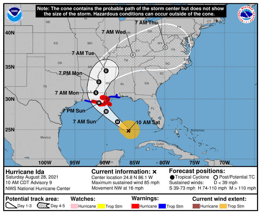
At 1000 AM CDT (1500 UTC), the center of Hurricane Ida was located near latitude 24.8 North, longitude 86.1 West. Ida is moving toward the northwest near 16 mph (26 km/h), and this general motion should continue through late Sunday or early Monday, followed by a slower northward motion on Monday. On the forecast track, the center of Ida will move over the southeastern Gulf of Mexico today and move over the central Gulf of Mexico tonight and early Sunday. Ida is then expected to make landfall along the U.S. northern Gulf coast within the hurricane warning area on Sunday, and then move inland over portions of Louisiana or western Mississippi later on Monday.
Maximum sustained winds are near 85 mph (140 km/h) with higher gusts. Rapid strengthening is forecast during the next 24 to 36 hours, and Ida is expected to be an extremely dangerous major hurricane when it approaches the northern Gulf coast on Sunday. Weakening is expected after Ida makes landfall.
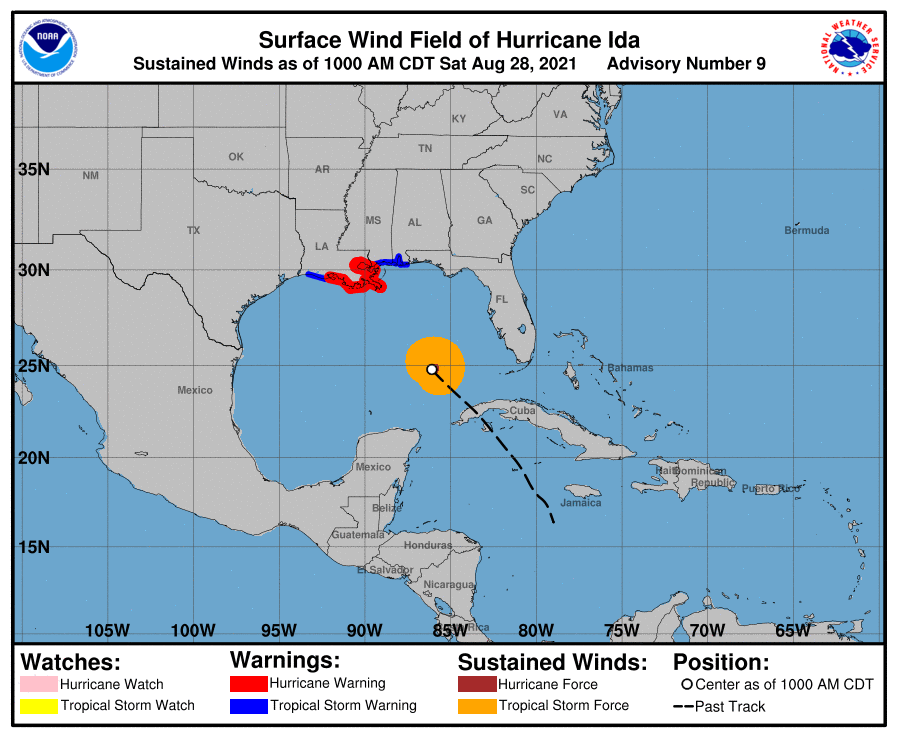
Hurricane-force winds extend outward up to 30 miles (45 km) from the center, and tropical-storm-force winds extend outward up to 125 miles (205 km). The latest minimum central pressure estimated from Air Force Reserve reconnaissance aircraft data is 984 mb (29.06 inches).
KEY MESSAGES
1. There is a danger of life-threatening storm surge inundation Sunday along the coasts of Louisiana and Mississippi within the Storm Surge Warning area. Extremely life-threatening inundation of 9 feet or greater above ground level is possible somewhere within the area from Morgan City, Louisiana, to the coast of Mississippi. Overtopping of local levees outside of the Hurricane and Storm Damage Risk Reduction System is possible where local inundation values may be higher. Interests throughout the warning area should follow any advice given by local officials.
2. Ida is expected to be an extremely dangerous major hurricane when it reaches the coast of Louisiana. Hurricane-force winds are expected Sunday in portions of the Hurricane Warning area along the Louisiana coast, including metropolitan New Orleans, with potentially catastrophic wind damage possible where the core of Ida moves onshore. Actions to protect life and property should be rushed to completion today in the warning area.
3. Ida is likely to produce heavy rainfall Sunday and Monday across the central Gulf Coast from southeast Louisiana to coastal Mississippi, resulting in life-threatening flash and urban flooding and significant river flooding impacts. As Ida moves inland, significant flooding impacts are likely across portions of the Lower Mississippi and Tennessee Valleys Monday and Tuesday.
HAZARDS TO LAND
STORM SURGE: The combination of a dangerous storm surge and the tide will cause normally dry areas near the coast to be flooded by rising waters moving inland from the shoreline. The water could reach the following heights above ground somewhere in the indicated areas if the peak surge occurs at the time of high tide…
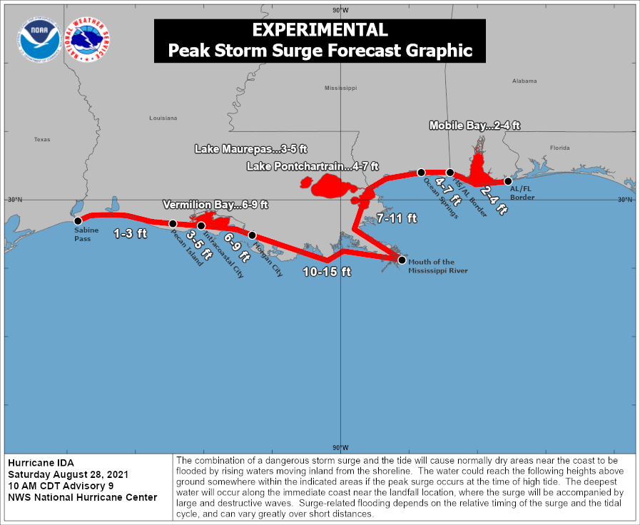
* Morgan City, LA to Mouth of the Mississippi River…10-15 ft
* Mouth of the Mississippi River to Ocean Springs, MS including Lake Borgne…7-11 ft
* Intracoastal City, LA to Morgan City, LA including Vermilion Bay…6-9 ft
* Ocean Springs, MS to MS/AL border…4-7 ft
* Lake Pontchartrain…4-7 ft
* Lake Maurepas…3-5 ft
* Pecan Island, LA to Intracoastal City, LA…3-5 ft
* MS/AL border to AL/FL border including Mobile Bay…2-4 ft
* Sabine Pass to Pecan Island, LA…1-3 ft
Overtopping of local levees outside of the Hurricane and Storm Damage Risk Reduction System is possible where local inundation values may be higher than those shown above.
The deepest water will occur along the immediate coast near and to the east of the landfall location, where the surge will be accompanied by large and dangerous waves. Surge-related flooding depends on the relative timing of the surge and the tidal cycle, and can vary greatly over short distances. For information specific to your area, please see products issued by your local National Weather Service forecast office.
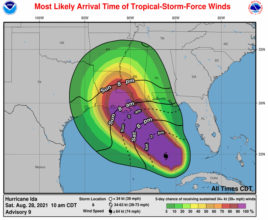
WIND: Hurricane conditions are expected in the hurricane warning area along the Louisiana coast beginning Sunday, with tropical storm conditions expected to begin by late tonight or early Sunday morning. These conditions will spread inland over portions of Louisiana and Mississippi Sunday night and Monday.
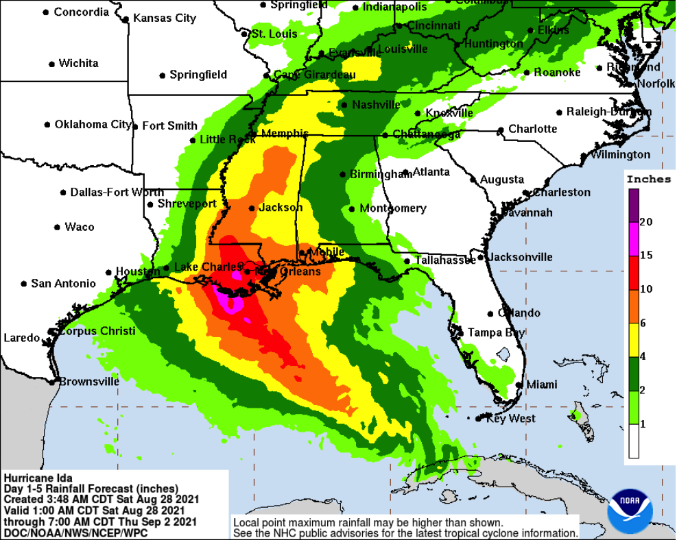
RAINFALL: Heavy rainfall from Ida will begin to impact the Louisiana coast Sunday morning, spreading northeast into the Lower Mississippi Valley later Sunday into Monday. Total rainfall accumulations of 8 to 16 inches, with isolated maximum amounts of 20 inches, are possible across southeast Louisiana and southern Mississippi through Monday. This is likely to result in life-threatening flash and urban flooding impacts and significant riverine flooding impacts.
Ida is forecast to turn northeast later Monday, with rainfall totals of 4 to 8 inches possible from northeastern Louisiana and central Mississippi into the Tennessee Valley. This is likely to result in considerable flash and riverine flooding impacts.
Rainfall impacts from Ida will diminish across western Cuba today as the storm continues to lift northward away from the island. An additional 1 to 2 inches of rain, with isolated maximum amounts of 4 inches, are possible across western Cuba through today. These rainfall amounts may produce flash floods and mudslides.
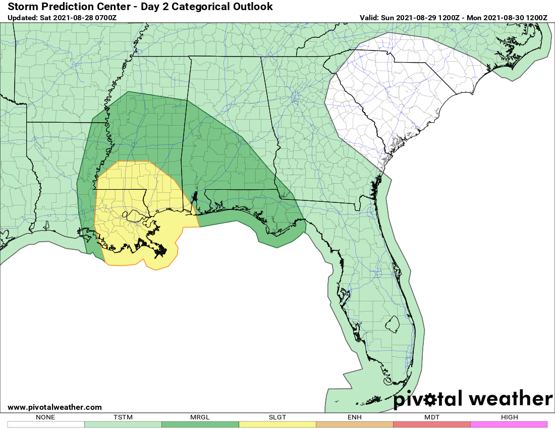
TORNADOES: Tornadoes will be possible Sunday into Monday across the northern Gulf coast states, including parts of eastern Louisiana, Mississippi, central and southern Alabama, and the Florida Panhandle. The longest duration tornado threat will exist across southeast Louisiana and southern Mississippi.
SURF: Swells generated by Ida will continue to affect western Cuba through today. Swells will begin reaching portions of the northern Gulf coast later today and continue through Monday. These swells are likely to cause life-threatening surf and rip current conditions. Please consult products from your local weather office.
All images, forecasts, and documents are courtesy of their respective publishers.
Category: Alabama's Weather, ALL POSTS, Severe Weather, Tropical
About the Author (Author Profile)
Scott Martin is an operational meteorologist, professional graphic artist, musician, husband, and father. Not only is Scott a member of the National Weather Association, but he is also the Central Alabama Chapter of the NWA president. Scott is also the co-founder of Racecast Weather, which provides forecasts for many racing series across the USA. He also supplies forecasts for the BassMaster Elite Series events including the BassMaster Classic.Subscribe
If you enjoyed this article, subscribe to receive more just like it.


