Central Gulf Coast Impacts from Hurricane Ida Updated for New Track Forecast
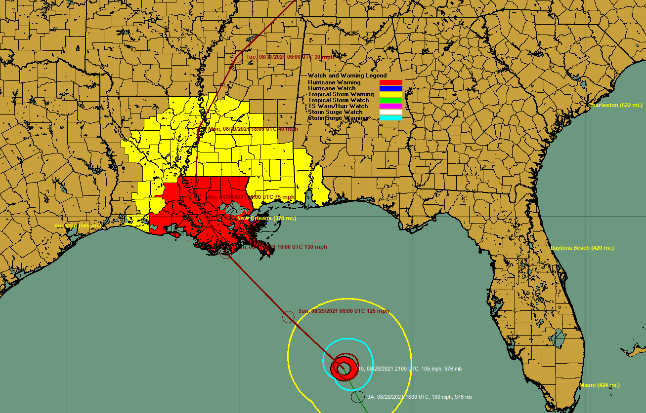
Ida appears to be on track to becoming the major hurricane it is forecast to become.
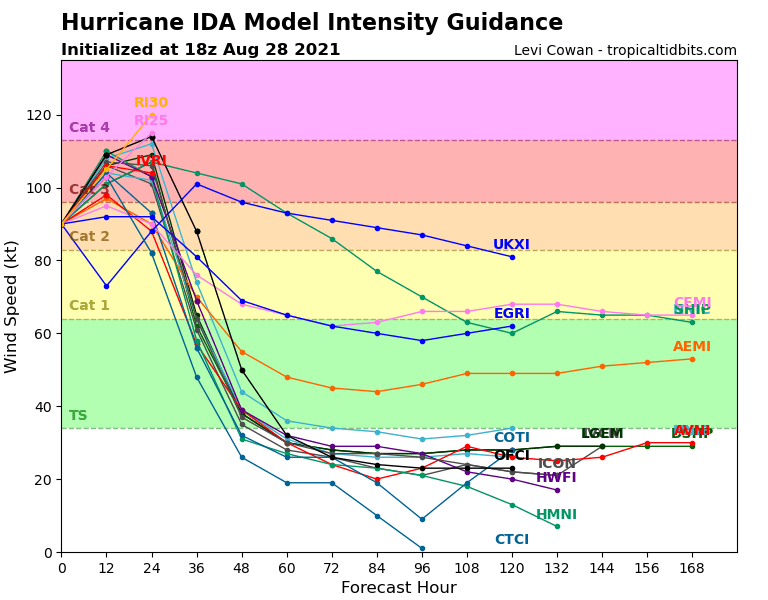
Afternoon model intensity forecasts seem to be bunched in the category 3 range with winds between 111-129 mph before landfall. A couple of them still make it a cat 4 hurricane.
The track guidance has shifted slightly to the east and it very tightly bunched in the Houma/Grand Isle area with a track somewhere within 75 miles west of New Orleans.
The official NHC track was shifted slightly to the east to account for the recent wobble to the right. The official track carries the center over Houma and then near Baton Rouge. This increases the wind threat for New Orleans just a bit.
But we caution that it could shift back to the west, and anyone in the hurricane warning area has to prepare for the worst.
Here are some impacts along the Central Gulf Coast:
HOUMA
Houma will see the center pass very close to the city late tomorrow afternoon. Houma could experience the eyewall and the eye. Tropical storm force winds will begin Sunday morning, increasing throughout the day until the eyewall arrives around mid-afternoon when winds could reach 115-125 mph with gusts to 145 mph. Winds could even be slightly higher than that. Houma will experience hurricane force winds for around 5-6 hours. Winds will remain above tropical storm force until around 3-4 a.m. Monday. Houma will experience extensive damage, including collapsed walls and roofs removed. Rainfall will range from 12-16 inches. Houma is under a Hurricane Warning and a Storm Surge Warning. Surge models indicate much of Houma could be flooded by up to 6-9 feet of surge flooding.
NEW ORLEANS
The Crescent City is under a Hurricane Warning. Winds have increased slightly on this forecast due to the slight eastward shift. Tropical storm force winds will begin around sunrise Sunday morning and increase until early afternoon when strong tropical storm force winds (near 60 mph) will arrive. Peak winds will occur during the late afternoon, reaching 65-75 mph with gusts to 80-85 mph. 12-16 inches of rain will occur as well. Peak surge in Lake Ponchartrain could reach 5-8 feet. New Orleans will be in tropical storm force winds for nearly 24 hours, ending early Monday morning.
BATON ROUGE
Hurricane Warning in effect. Tropical storm force winds will begin late Sunday morning. Strong tropical storm force winds will arrive in Baton Rouge around sunset. Peaks winds will occur around 10-11 p.m. with the eyewall passing near Baton Rouge. Winds will reach 85-95 mph with gusts to 100-110 mph. There will be significant wind damage to homes and businesses. Winds should diminish by 7-8 a.m. Monday. Rain will reach 10-12 inches.
HAMMOND
The wind forecast for Hammond has increased slightly. Tropical storm force winds will start as early as 10 a.m. with strong tropical storm force winds by 7 p.m. The highest winds will be experienced around 9-10 pm when winds will reach 60-70 mph with gusts to near 80 mph. Tropical storm force winds will last about 20 hours, ending Monday morning about 7 a.m. rainfall will total 12-14 inches.
MOBILE
Now under a Storm Surge Warning in addition to the Tropical Storm Warning. Winds will increase to 30-40 mph during the morning and early afternoon at Mobile. Surge could reach 3-5 feet in Mobile. 6-10 inches of rain will fall in coastal Alabama. Mobile will see the potential for tornadoes tomorrow as will the southwestern half of Alabama as the circulation of Ida moves northwestward and northward.
GULF SHORES/ALABAMA COAST
Outer rainbands of Ida will start affecting Mobile and Baldwin Counties after midnight, with heavy rain and storms early Sunday morning. Heavy rain and strong storms will cover southwestern Alabama by afternoon, extending back into the Florida Panhandle with a tornado threat. Winds will reach 30-40 mph Sunday morning with gusts to 40-45 mph. Rainfall should be 5-8 inches. There will be a tornado threat Sunday and Monday.
BILOXI MS
Tropical Storm Warning and Storm Surge Warning in effect. Expect tropical storm force winds starting Sunday morning around 9-10 a.m. Winds should peak around noon into the early afternoon when they could reach 40-50 mph with gusts to 50-60 mph. Winds will decrease after sunset but will remain gusty into Monday. Tornadoes will be a significant threat.
FOR US IN CENTRAL ALABAMA: Strong storms will reach Montgomery by mid-afternoon and Tuscaloosa/Birmingham by late afternoon. A solid shield of heavy rain will advance northeastward across Alabama late Sunday night and Monday morning. Rainfall amounts over the state will be 2-5 inches, mainly west of I-65 with some flooding. There will be a tornado threat on Monday and Tuesday across all of Central into North Alabama. Winds will reach 25 mph over Central Alabama Monday night into Tuesday with occasional gusts to 40 mph over western sections of the state and in the higher elevations of Northeast Alabama.
Category: Alabama's Weather, ALL POSTS, Tropical
About the Author (Author Profile)
Bill Murray is the President of The Weather Factory. He is the site's official weather historian and a weekend forecaster. He also anchors the site's severe weather coverage. Bill Murray is the proud holder of National Weather Association Digital Seal #0001 @wxhistorianSubscribe
If you enjoyed this article, subscribe to receive more just like it.


