10 am Advisory — Eye of Extremely Dangerous Ida Nearing the SoutheastCoast of Louisiana
SUMMARY OF 10 AM CDT INFORMATION
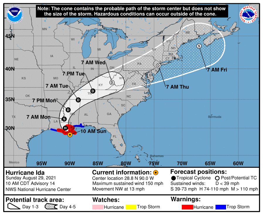
LOCATION…28.8N 90.0W
ABOUT 60 MI…95 KM WSW OF THE MOUTH OF THE MISSISSIPPI RIVER
ABOUT 85 MI…135 KM S OF NEW ORLEANS, LOUISIANA
MAXIMUM SUSTAINED WINDS…150 MPH…240 KM/H
PRESENT MOVEMENT…NW OR 320 DEGREES AT 13 MPH…20 KM/H
MINIMUM CENTRAL PRESSURE…933 MB…27.55 INCHES
WATCHES AND WARNINGS
A Storm Surge Warning is in effect for…
* Intracoastal City, Louisiana to the Alabama/Florida border
* Vermilion Bay, Lake Borgne, Lake Pontchartrain, Lake Maurepas, and Mobile Bay
A Hurricane Warning is in effect for…
* Intracoastal City, Louisiana to the Mouth of the Pearl River
* Lake Pontchartrain, Lake Maurepas, and Metropolitan New Orleans
A Tropical Storm Warning is in effect for…
* Cameron Louisiana to west of Intracoastal City, Louisiana
* Mouth of the Pearl River to the Alabama/Florida border
FORECAST DISCUSSION
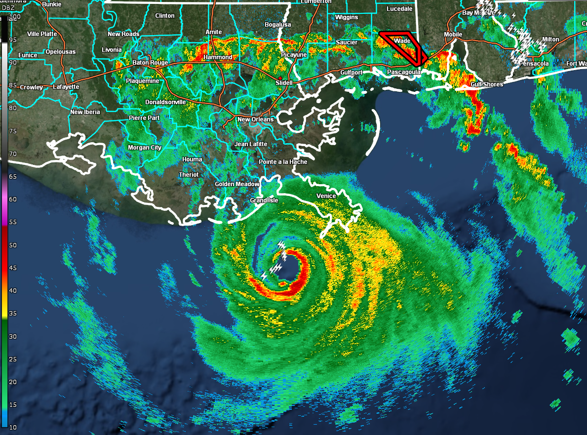
At 1000 AM CDT (1500 UTC), the eye of Hurricane Ida was located by reconnaissance aircraft and NWS Doppler radar near latitude 28.8 North, longitude 90.0 West. Ida is moving toward the northwest near 13 mph (20 km/h). A slightly slower northwestward motion should continue through this evening. A turn toward the north should occur by Monday morning, followed by a slightly faster northeastward motion by Monday night and Tuesday. On the forecast track, the center of Ida will make landfall along the coast of southeastern Louisiana within the hurricane warning area within the next few hours. Ida is then forecast to move well inland over portions of Louisiana and western Mississippi Monday and Monday night, and move across the Tennessee Valley on Tuesday.
Reports from NOAA and Air Force Reserve Hurricane Hunter aircraft indicated that the maximum sustained winds are near 150 mph (240 km/h) with higher gusts. Ida is an extremely dangerous category 4 hurricane on the Saffir-Simpson Hurricane Wind Scale. Some slight additional strengthening is still possible before Ida moves onshore along the Louisiana coast. Rapid weakening is expected after landfall.
Hurricane-force winds extend outward up to 50 miles (85 km) from the center, and tropical-storm-force winds extend outward up to 150 miles (240 km). An elevated NOAA C-MAN station at Southwest Pass recently reported a sustained wind of 105 mph (169 km/h) and a wind gust of 121 mph (194 km/h). A station in Shell Beach, Louisiana, recently reported a sustained wind of 44 mph (70 km/h) and a gust of 52 mph (83 km/h).
A NOAA National Ocean Service tide gauge in Shell Beach, Louisiana, recently reported a water level of 5.6 feet above mean higher high water, which is an approximation of inundation in that area.
The latest minimum central pressure reported by an Air Force Reserve reconnaissance aircraft is 933 mb (27.55 inches).
KEY MESSAGES
1. Extremely life-threatening storm surge inundation of 9 feet or greater above ground level is imminent somewhere within the area from Burns Point, Louisiana, to Ocean Springs, Mississippi. Overtopping of local levees outside of the Hurricane and Storm Damage Risk Reduction System is possible where local inundation values may be higher.
2. Catastrophic wind damage will occur where the core of Ida moves onshore along the southeast coast of Louisiana in the next few hours. Hurricane-force winds and damaging wind gusts are expected today within the Hurricane Warning in southeastern Louisiana, including metropolitan New Orleans.
3. Damaging winds, especially in gusts, will spread inland near the track of the center of Ida into southwestern Mississippi tonight and early Monday. These winds will likely lead to widespread tree damage and power outages.
4. Ida will continue to produce heavy rainfall today through Monday across the central Gulf Coast from southeast Louisiana, coastal Mississippi, and far southwestern Alabama, resulting in considerable to life-threatening flash and urban flooding and significant river flooding impacts. As Ida moves inland, significant flooding impacts are possible across portions of the Lower Mississippi, Tennessee Valley, Upper Ohio Valley, Central Appalachians and the Mid-Atlantic through Wednesday.
HAZARDS TO LAND
STORM SURGE: The combination of a dangerous storm surge and the tide will cause normally dry areas near the coast to be flooded by rising waters moving inland from the shoreline. The water could reach the following heights above ground somewhere in the indicated areas if the peak surge occurs at the time of high tide…
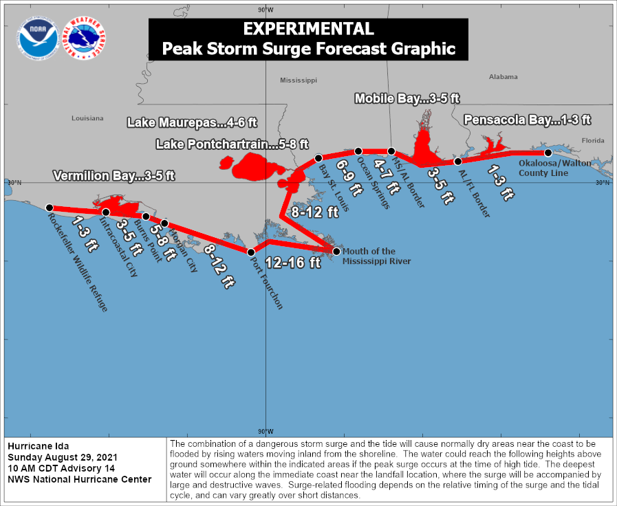
* Port Fourchon, LA to Mouth of the Mississippi River…12-16 ft
* Morgan City, LA to Port Fourchon, LA…8-12 ft
* Mouth of the Mississippi River to Bay St. Louis, MS including Lake Borgne…8-12 ft
* Bay St. Louis, MS to Ocean Springs, MS…6-9 ft
* Burns Point, LA to Morgan City, LA…5-8 ft
* Lake Pontchartrain…5-8 ft
* Ocean Springs, MS to MS/AL border…4-7 ft
* Lake Maurepas…4-6 ft
* East of Intracoastal City, LA to Burns Point, LA including Vermilion Bay…3-5 ft
* MS/AL border to AL/FL border including Mobile Bay…3-5 ft
* Rockefeller Wildlife Refuge, LA to Intracoastal City, LA…1-3 ft
* AL/FL border to Okaloosa/Walton County Line, including Pensacola Bay…1-3 ft
Overtopping of local levees outside of the Hurricane and Storm Damage Risk Reduction System is possible where local inundation values may be higher than those shown above.
The deepest water will occur along the immediate coast near and to the east of the landfall location, where the surge will be accompanied by large and dangerous waves. Surge-related flooding depends on the relative timing of the surge and the tidal cycle, and can vary greatly over short distances.
WIND: Catastrophic wind damage is likely where the core of Ida moves onshore along the southeast coast of Louisiana in the next few hours.
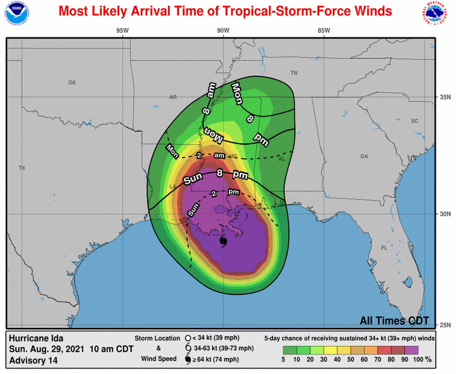
Hurricane conditions will spread inland within the Hurricane Warning area over southeastern Louisiana through tonight. Tropical storm conditions will also spread inland over portions of Louisiana and Mississippi tonight and Monday.
RAINFALL: Heavy rainfall from Ida will continue to impact the southeast Louisiana coast this morning, spreading northeast into the Lower Mississippi Valley later today into Monday. Total rainfall accumulations of 10 to 18 inches, with isolated maximum amounts of 24 inches, are possible across southeast Louisiana into far southern Mississippi through Monday. This is likely to result in life-threatening flash and urban flooding and significant riverine flooding impacts.
Ida is forecast to turn to the northeast early Monday and track across the Middle Tennessee Valley and Upper Ohio Valley through Wednesday, producing the following rainfall totals:
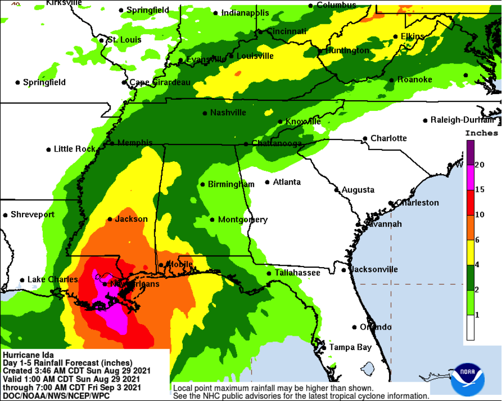
* Coastal Alabama to the far western Florida panhandle: 5 to 10 inches, with isolated maximum amounts of 15 inches, today through Tuesday morning.
* Central Mississippi: 4 to 8 inches, with isolated maximum amounts of 12 inches, tonight through Monday night.
* Middle Tennessee Valley, Upper Ohio Valley, Central Appalachians into the Mid-Atlantic: 3 to 6 inches with isolated higher amounts, Tuesday into Wednesday.
These rainfall totals will result in considerable flash and riverine flooding.
TORNADOES: Tornadoes will be most likely through Monday over southeast Louisiana, southern Mississippi, southwest Alabama, and the western Florida Panhandle. A few tornadoes are also possible farther north across much of Mississippi and Alabama on Monday.
SURF: Swells will affect the northern Gulf coast through early Monday. These swells are likely to cause life-threatening surf and rip current conditions.
All images, forecasts, and documents are courtesy of their respective publishers.
Category: Alabama's Weather, ALL POSTS, Severe Weather, Tropical
About the Author (Author Profile)
Scott Martin is an operational meteorologist, professional graphic artist, musician, husband, and father. Not only is Scott a member of the National Weather Association, but he is also the Central Alabama Chapter of the NWA president. Scott is also the co-founder of Racecast Weather, which provides forecasts for many racing series across the USA. He also supplies forecasts for the BassMaster Elite Series events including the BassMaster Classic.Subscribe
If you enjoyed this article, subscribe to receive more just like it.


