Dual Threat Of Flooding/Isolated Tornadoes Continues
**No afternoon Weather Xtreme video today**
BIG PICTURE: Tropical Storm Ida continues to weaken this afternoon; the center of circulation is about 20 miles west of Jackson, Mississippi, and sustained winds are down to 40 mph. There is a large rain shield east of Ida across the eastern half of Mississippi and the western 2/3 of Alabama this afternoon. This is what to expect in Alabama through tomorrow. This is what to expect in Alabama through tomorrow…
WIND: Winds could gust to 30-40 mph over West Alabama this evening and tonight as Ida turns to the northeast. This won’t be enough to create large power outages, but a few isolated trees could come down. Winds over East Alabama tonight will gust to 20-25 mph.
RAIN: Rain totals across West Alabama by tomorrow evening will be in the 2-4 inch range; totals for East Alabama will be generally 1-2 inches. Some isolated flooding issues are possible… a flash flood watch is in effect for almost all of Alabama through tomorrow. If you live in a flood prone area, pay attention to flash flood warnings.
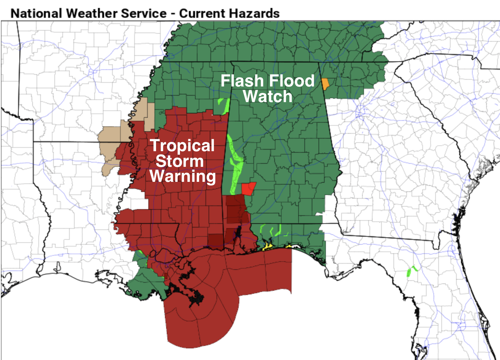
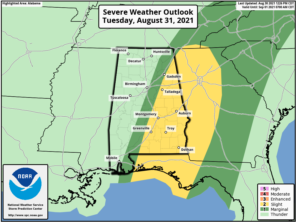
TORNADOES: A few isolated, brief tornadoes are possible across Alabama tonight and tomorrow. The higher tornado probabilities tomorrow are for areas east and south of Birmingham. A tornado touched down today in the Saraland/Creola area of Mobile County producing significant damage and a few minor injuries.
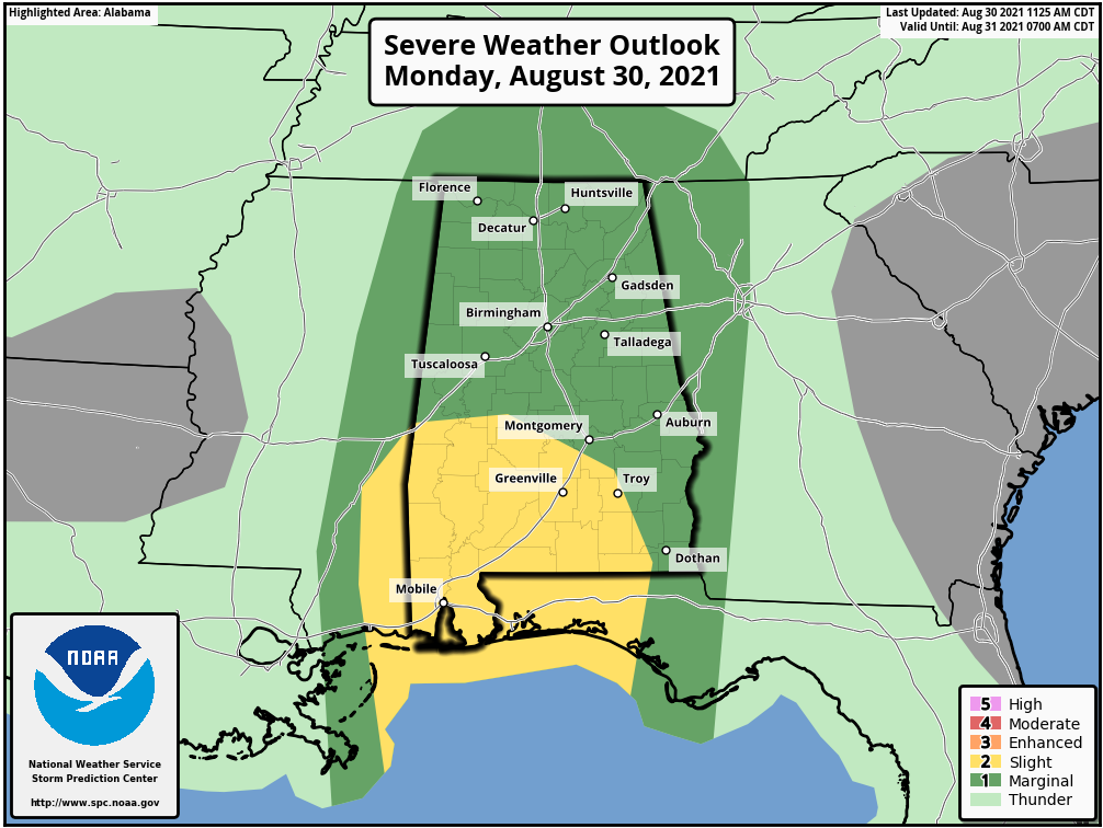
Keep in mind most tornadoes associated with tropical systems are short lived, low topped, and can be literally under the radar. Sometimes they can touch down with little or no warning, so be very weather aware tonight and tomorrow.
Rain will taper off tomorrow night as Ida pulls away from Alabama, and any we expect just a few lingering, widely scattered showers Wednesday.
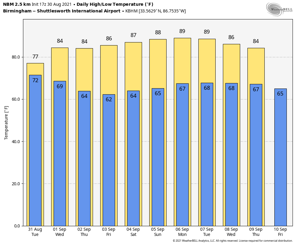
THURSDAY THROUGH THE WEEKEND: Dry air settles into the state Wednesday night, and we are looking at very nice early September weather Thursday through the weekend with sunny days, clear cooler nights, and lower humidity levels. Highs will be in the 80s, and lows mostly in the 60s, but cooler spots will drop into the 50s across North/Central Alabama both Thursday and Friday morning. Great weather for both high school and college football games across the Deep South.
TROPICS: Tropical Storm Kate formed this morning in the Central Atlantic; it will move northward, stay weak, and far from land. A tropical wave coming off the coast of Africa has a high chance of becoming a tropical depression or storm over the next two days; the name will be “Larry”. Remains to be seen if this turns northward into the open Atlantic, or keep moving toward the Lesser Antilles.
And. a broad area of low pressure is expected to form in the southern Caribbean Sea by midweek. Environmental conditions appear to be favorable for some slow development by the end of the week, as long as the system remains over water. This system is expected to move gradually west-northwestward or northwestward at 5 to 10 mph over the western Caribbean Sea near the east coast of Central America. Too early to know if this makes it into the Gulf of Mexico.
ON THIS DATE IN 1838: A major tornado, possibly the worst in Rhode Island history, passed south of Providence. It uprooted and stripped trees of their branches, unroofed or destroyed many houses, and sucked water out of ponds. The tornado barely missed a local railroad depot, where many people were waiting for a train.
BEACH FORECAST: Click here to see the AlabamaWx Beach Forecast Center page.
WEATHER BRAINS: Don’t forget you can listen to our weekly 90 minute show anytime on your favorite podcast app. This is the show all about weather featuring many familiar voices, including our meteorologists here at ABC 33/40.
CONNECT: You can find me on all of the major social networks…
Look for the next Weather Xtreme video here by 6:00 a.m. tomorrow…
Category: Alabama's Weather, ALL POSTS
About the Author (Author Profile)
James Spann is one of the most recognized and trusted television meteorologists in the industry. He holds the AMS CCM designation and television seals from the AMS and NWA. He is a past winner of the Broadcast Meteorologist of the Year from both professional organizations.Subscribe
If you enjoyed this article, subscribe to receive more just like it.


