A Few Showers Tomorrow; Dry Labor Day Weekend Ahead
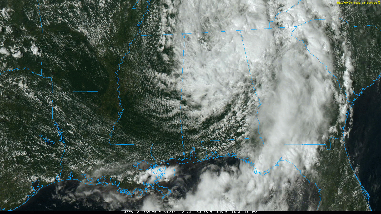
RADAR CHECK: Rain is still falling across much of Central and East Alabama this afternoon as Ida lifts out to the northeast. The threat of isolated tornadoes has ended for the state, and the rain will taper off tonight from southwest to northeast. Temperatures are in the 70s over the northern 2/3 of the state; the average high for August 31 at Birmingham is 89.
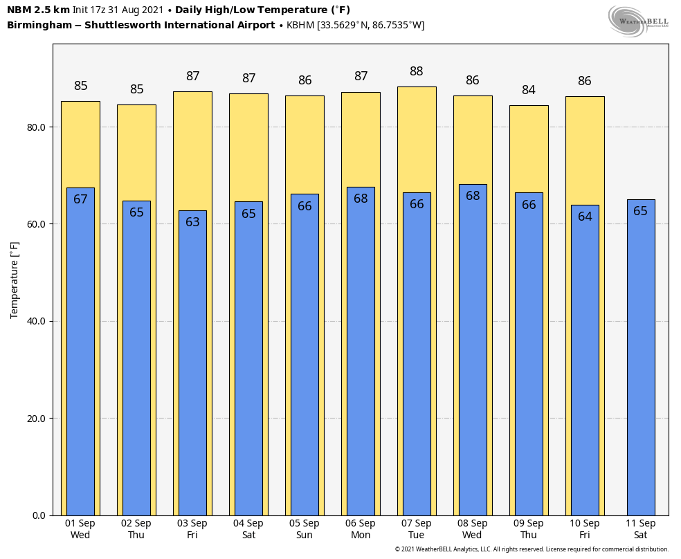
TOMORROW: It will be a warm, humid day with a mix of sun and clouds. A surface boundary will drop into the state, and that should produce scattered showers and thunderstorms, mostly during the afternoon and evening hours. Chance of any one spot getting wet tomorrow is around 30 percent, and the high will be in the mid 80s.
THURSDAY THROUGH THE WEEKEND: A very dry airmass follows the front tomorrow night, and the stage is set for some very nice weather for Alabama and the Deep South Thursday through the holiday weekend. Sunny days, fair pleasant nights, and lower humidity levels. Highs will be mostly in the mid to upper 80s, with lows in the 60s. But, cooler spots will see lows in the 50s early Thursday and Friday morning for a nice hint of coming attractions. It doesn’t get much better in early September around here.
REST OF NEXT WEEK: The weather looks mostly dry for the rest of next week; there could be a day or two with some risk of isolated showers, but no sign of any widespread rain opportunities. Highs will be mostly in the upper 80s… See the Weather Xtreme video for maps, graphics, and more details.
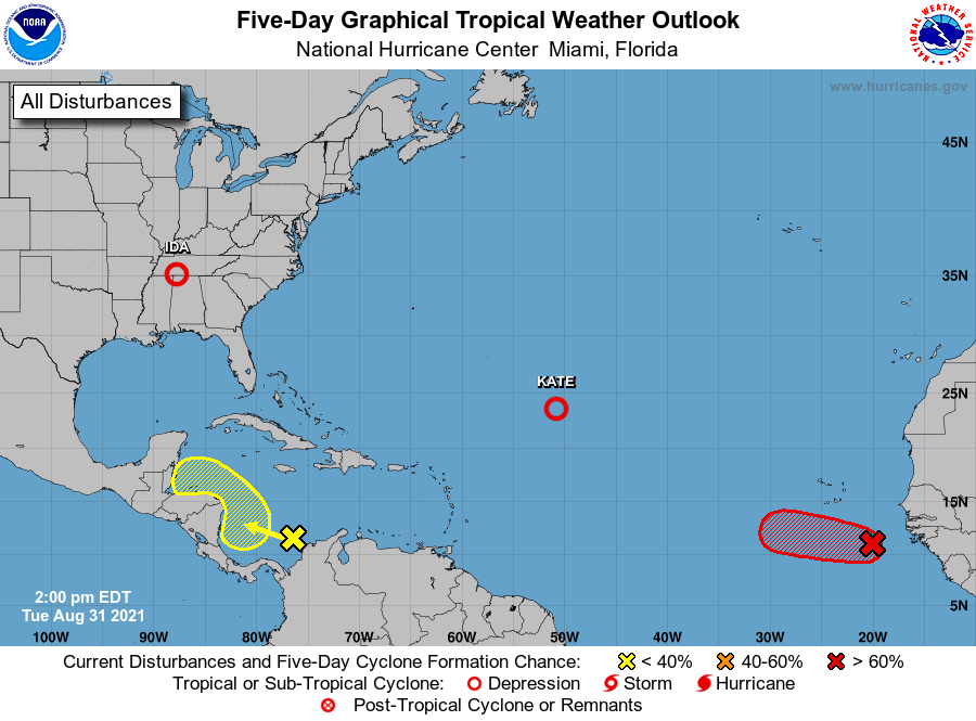
TROPICS: Kate is a weak, disorganized, sheared tropical depression in the middle of the Atlantic that won’t impact an landmass. A tropical wave in the southern Caribbean will be monitored, for it looks like it will move into Central America in 3-5 days without development, but know that is not totally carved in stone. For now NHC gives it only a 20 percent chance of development over the next five days.
And, a well organized tropical wave in the far eastern Atlantic is expected to become Tropical Storm Larry over the next few days. It will gain latitude, and is expected to recurve into the Atlantic well east of the U.S. There are no systems threatening the Central Gulf Coast through the Labor Day weekend.
ON THIS DATE IN 1886: A magnitude 7.3 earthquake shook Charleston, South Carolina around 9:50 pm on this day. This earthquake is the most damaging quake to occur in the southeast United States. This earthquake caused 60 deaths and between 5 to 6 million dollars in damage to over 2,000 buildings in the southeastern United States.
BEACH FORECAST: Click here to see the AlabamaWx Beach Forecast Center page.
WEATHER BRAINS: Don’t forget you can listen to our weekly 90 minute show anytime on your favorite podcast app. This is the show all about weather featuring many familiar voices, including our meteorologists here at ABC 33/40.
CONNECT: You can find me on all of the major social networks…
Look for the next Weather Xtreme video here by 6:00 a.m. tomorrow…
Category: Alabama's Weather, ALL POSTS, Weather Xtreme Videos
About the Author (Author Profile)
James Spann is one of the most recognized and trusted television meteorologists in the industry. He holds the AMS CCM designation and television seals from the AMS and NWA. He is a past winner of the Broadcast Meteorologist of the Year from both professional organizations.Subscribe
If you enjoyed this article, subscribe to receive more just like it.


