Dry Airmass Pushes Into Alabama Tonight/Tomorrow
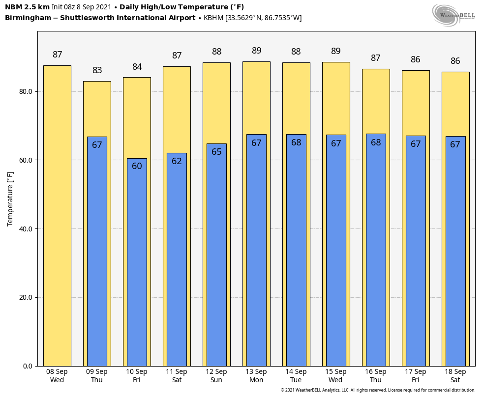
RADAR CHECK: Most of the state is dry this morning, but showers are over far South Alabama due to a tropical disturbance in the Gulf of Mexico. Look for a mix of sun and clouds today with a few scattered showers or thunderstorms by afternoon ahead of a cold front. Temperatures will reach the 85-88 degree range today… the average high for Birmingham on September 8 is 88. Showers will end tonight as the front pushes southward, and a nice surge of dry air rolls into the state.
TOMORROW THROUGH THE WEEKEND: We are forecasting sunny days, fair pleasant nights, and lower humidity levels tomorrow through Sunday. Highs will be in the mid 80s tomorrow and Friday, followed by upper 80s over the weekend. Lows will be mostly in the 60s, but most of North/Central Alabama will enjoy a low in the 50s Friday morning… it will be the coolest morning so far this season.
NEXT WEEK: Moisture begins to return Monday; we will mention a chance of isolated showers. Then, Tuesday through Friday we expect partly sunny days with scattered showers and thunderstorms possible. Highs will be in the mid to upper 80s next week… See the Weather Xtreme video for maps, graphics, and more details.
FOOTBALL WEATHER: Expect perfect weather for the high school games across the state Friday night; the sky will be clear with temperatures falling from the upper 70s at kickoff into the upper 60s by the final whistle.
Saturday, Auburn hosts Alabama State at Jordan-hare Stadium (11a CT kickoff)… look for a sunny sky during the game with temperatures rising from near 84 degrees at kickoff to around 87 by the fourth quarter. Alabama will host Mercer at Bryant-Denny Stadium (3p CT kickoff)… the sky will be sunny with temperatures falling from 88 degrees at kickoff to near 80 degrees by the end of the game.
UAB is on the road; they will take on the Georgia Bulldogs in Athens (2:30p CT kickoff)… the sky will be sunny; about 87 degrees at kickoff, falling to near 81 by the final whistle. And, Jacksonville State is also on the road Saturday night; they take on Florida State in Tallahassee (7p CT kickoff). A shower is possible during the first half, otherwise the sky will be mostly fair with temperatures hovering in the 78-82 degree range during the game.
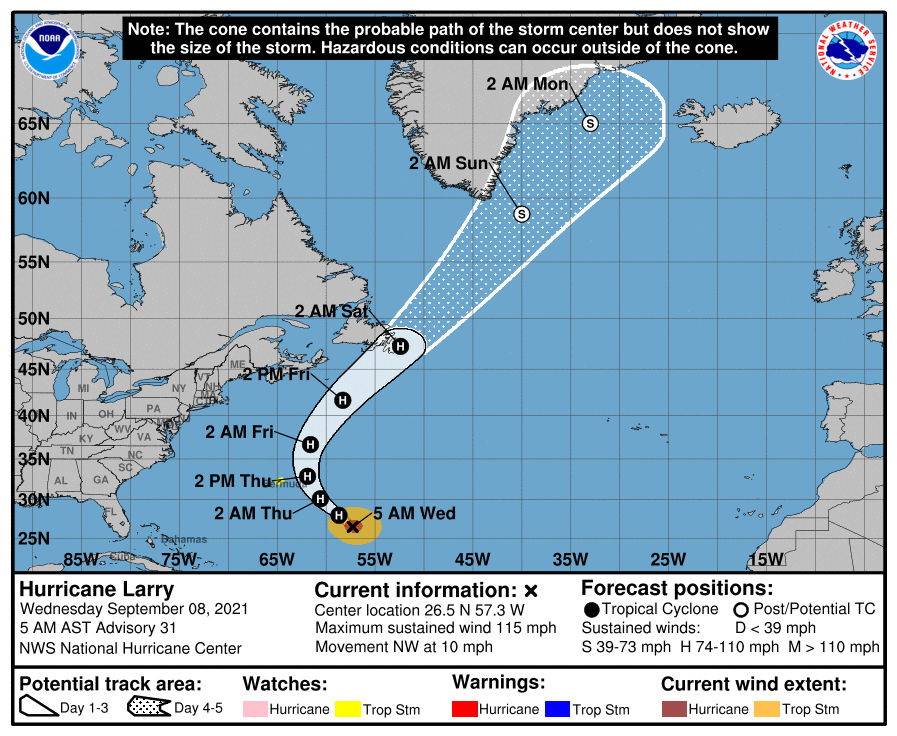
TROPICS: Hurricane Larry this morning is about 600 miles southeast of Bermuda in the Atlantic, and has sustained winds of 115 mph. It will recurve into the open Atlantic well east of the U.S…. but will be close enough to Bermuda to bring tropical storm conditions to the island tomorrow. Significant swells will begin to reach the east coast of the United States and Atlantic Canada later today and continue affecting these shores through the end of the week. These swells will likely cause life-threatening surf and rip current conditions.
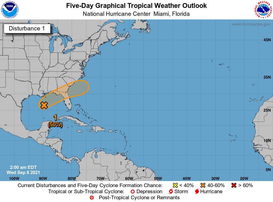
Closer to home, disorganized cloudiness and a few thunderstorms over the central and eastern Gulf of Mexico are associated with a surface trough and an upper-level disturbance. The system is expected to move northeastward over the northeastern Gulf of Mexico later today.Upper-level winds could become slightly more favorable to support some tropical or subtropical development as the system nears the northern Gulf coast tonight or early Thursday. The disturbance is then expected to cross the southeastern United States, and some additional development will be possible after it emerges off the southeastern United States coast late this week. Regardless of development, areas of heavy rainfall will be possible across portions of the Florida panhandle and southern Georgia through Thursday, with localized flooding possible.
NHC gives this feature a 50 percent chance of becoming a tropical depression or storm over the next 48 hours. The weather will improve along the Central Gulf Coast tomorrow as the disturbance moves away.
The MDR (Main Development Region) of the Atlantic basin is very quiet for mid-September.
ON THIS DATE IN 1900: A Category 4 hurricane made landfall in Galveston, Texas; it killed between 6,000 and 12,000 individuals, making it the deadliest U.S. Atlantic hurricane on record. The highest point in the city of Galveston was less than nine feet above sea level. The hurricane brought a storm surge of over 15 feet, which overwhelmed the entire island.
BEACH FORECAST: Click here to see the AlabamaWx Beach Forecast Center page.
WEATHER BRAINS: Don’t forget you can listen to our weekly 90 minute show anytime on your favorite podcast app. This is the show all about weather featuring many familiar voices, including our meteorologists here at ABC 33/40.
CONNECT: You can find me on all of the major social networks…
Look for the next Weather Xtreme video here by 3:00 this afternoon… enjoy the day!
Category: Alabama's Weather, ALL POSTS, Weather Xtreme Videos
About the Author (Author Profile)
James Spann is one of the most recognized and trusted television meteorologists in the industry. He holds the AMS CCM designation and television seals from the AMS and NWA. He is a past winner of the Broadcast Meteorologist of the Year from both professional organizations.Subscribe
If you enjoyed this article, subscribe to receive more just like it.


