Dry Pattern Continues; Warmer Afternoons
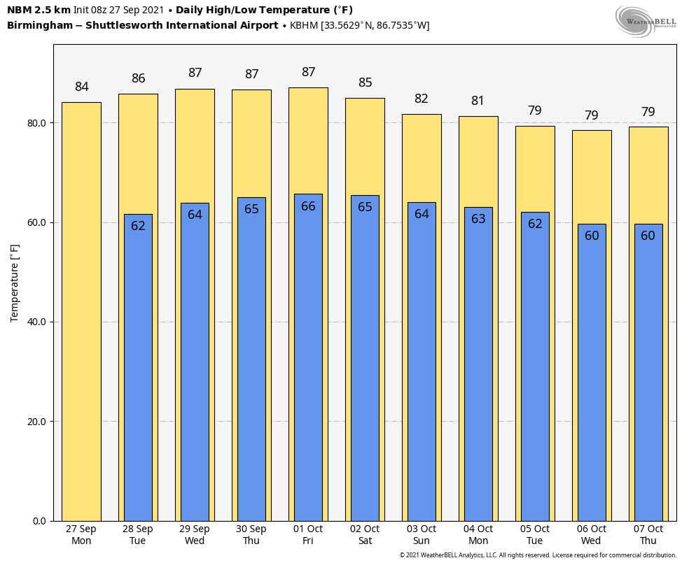
QUIET WEATHER PATTERN: Dry air remains in place across Alabama this morning with temperatures generally between 55 and 62 degrees at daybreak. Look for a sunny sky again today with a high in the mid 80s; the average high for Birmingham on September 27 is 83. Dry weather continues tomorrow and Wednesday with a warming trend; temperatures will reach the upper 80s in spots Wednesday afternoon.
THURSDAY THROUGH THE WEEKEND: There is evidence that moisture levels will rise a bit Thursday and Friday, with some risk of isolated showers on these days. But most places will stay warm and dry with a high in the mid 80s. Not much change for the weekend… we expect a partly to mostly sunny sky Saturday and Sunday with highs in the mid 80s. The chance of a shower is so small we won’t mention it in the forecast.
NEXT WEEK: The weather pattern still looks relatively quiet and warm. There would be sufficient moisture for a few isolated or widely scattered showers or a day or two, but prospects for a significant, widespread rain event look low for now. See the Weather Xtreme video for maps, graphics, and more details.
TROPICS: Sam is a little weaker this morning, but still a major hurricane with sustained winds of 130 mph. It is in the Atlantic about 800 miles east of the northern Leeward Islands, and is expected to remain a major hurricane over the next five days. Thankfully Sam will turn north and remain well east of the U.S… and will most likely pass east of Bermuda in 5-7 days.
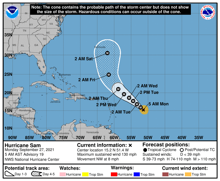
Out in the deep tropics, there are two tropical waves with a high chance of becoming a tropical depression or storm this week. Way too early to know if these systems will impact the Lesser Antilles or the U.S.
RAIN UPDATE: These are rain totals since January 1, and the departure from average…
Mobile 72.93″ (+20.54″)
Tuscaloosa 58.76″ (+18.79″)
Huntsville 54.53″ (+14.43″)
Birmingham 54.11″ (+10.45″)
Dothan. 51.83″ (+9.72″)
Muscle Shoals 50.65″ (+9.99″)
Montgomery 44.27″ (+5.31″)
Anniston 38.94″ (-0.37″)
ON THIS DATE IN 1906: The second September storm of 1906 was one of great violence. On the 27th the hurricane reached the central Gulf Coast with destructive winds and unprecedented tides. At Pensacola, the tide was 10 feet above normal. At Mobile property damage was severe. An estimated 134 lives were lost on the central Gulf Coast from this storm.
ON THIS DATE IN 1985: Hurricane Gloria swept over the Outer Banks then rushed across Long Island, New England, and Canada. It was the first significant hurricane to hit New England in twenty-five years and brought heavy rains and high winds to the Mid-Atlantic states as well.
BEACH FORECAST: Click here to see the AlabamaWx Beach Forecast Center page.
WEATHER BRAINS: Don’t forget you can listen to our weekly 90 minute show anytime on your favorite podcast app. This is the show all about weather featuring many familiar voices, including our meteorologists here at ABC 33/40.
CONNECT: You can find me on all of the major social networks…
Look for the next Weather Xtreme video here by 3:00 this afternoon… enjoy the day!
Category: Alabama's Weather, ALL POSTS, Weather Xtreme Videos
About the Author (Author Profile)
James Spann is one of the most recognized and trusted television meteorologists in the industry. He holds the AMS CCM designation and television seals from the AMS and NWA. He is a past winner of the Broadcast Meteorologist of the Year from both professional organizations.Subscribe
If you enjoyed this article, subscribe to receive more just like it.


