

Midday Nowcast: Very Warm with Some Afternoon Showers Possible

Moisture levels are on the rise, meaning there will be more clouds in the sky and we will need to mention the chance of a few scattered showers during the afternoon hours. These looks to be mainly across West and South Alabama, and even there they will be few and far between as the chance for rain is around 20%.
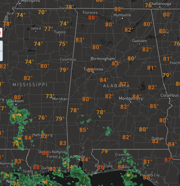
Rain chances are higher across Southwest Alabama and along the coast, where rain will be more widespread. Highs today and tomorrow will be in the mid 80s to low 90s across the state.
FRIDAY AND THE WEEKEND: An upper ridge will keep the state mostly dry and warm Friday and Saturday. Highs will remain in the mid 80s, slightly above average for early October. On Sunday, we expect a mix of sun and clouds with just a few widely scattered showers; Sunday’s high will be in the low 80s.
IN THE TROPICS: The National Hurricane Center is issuing advisories on Hurricane Sam located several hundred miles east of the northern Leeward Islands and newly formed Tropical Depression 20, which should become Victor soon.

1. Showers and thunderstorms remain disorganized in association with a trough of low pressure located several hundred miles southwest of the Cabo Verde Islands. Development of this system appears less likely due to the interaction with the larger low pressure area located to its east. The system is forecast to drift west-northwestward over the tropical central Atlantic during the next few days. Formation chance through 5 days…low…30 percent.
2. An area of low pressure associated with the remnants of Peter located several hundred miles south of the coast of Newfoundland is producing disorganized showers and thunderstorms. This system is moving northeastward into a region of very strong upper-level winds, and significant development is not anticipated. Formation chance through 5 days…low…10 percent.
HURRICANE SAM: The center of Hurricane Sam was located near latitude 19.4 North, longitude 57.0 West. Sam is moving toward the northwest near 9 mph, and this general motion with an increase in forward speed is expected during the next couple of days. A turn toward the north is forecast by Friday. On the forecast track, Sam will pass well to the east-northeast of the northern Leeward Islands through tonight.

Maximum sustained winds are near 130 mph with higher gusts. Sam is a category 4 hurricane on the Saffir-Simpson Hurricane Wind Scale. Some fluctuations in intensity are expected during the next couple of days, but Sam is forecast to remain a major hurricane through late this week. Hurricane-force winds extend outward up to 40 miles from the center and tropical-storm-force winds extend outward up to 125 miles. The minimum central pressure estimated from NOAA Hurricane Hunter aircraft observations is 949 mb (28.03 inches).
SOON TO BE VICTOR: The center of Tropical Depression Twenty was located near latitude 8.3 North, longitude 24.6 West. The depression is moving toward the west-northwest near 14 mph, and this motion is expected to continue during the next couple of days, followed by a turn to the northwest.
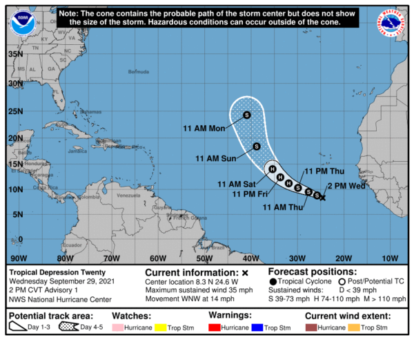
Maximum sustained winds are near 35 mph with higher gusts. Steady strengthening is forecast, and the depression is expected to become a tropical storm tonight and a hurricane in a couple of days. The estimated minimum central pressure is 1007 mb (29.74 inches).
BEACH FORECAST CENTER: Get the latest weather and rip current forecasts for the beaches from Fort Morgan to Panama City on our Beach Forecast Center page. There, you can select the forecast of the region that you are interested in visiting.
WORLD TEMPERATURE EXTREMES: Over the last 24 hours, the highest observation outside the U.S. was 123.8F at Omidieh, Iran. The lowest observation was -99.4F at University Dome, Antarctica.
CONTIGUOUS TEMPERATURE EXTREMES: Over the last 24 hours, the highest observation was 102F at Falcon Lake, TX. The lowest observation was 21F at Peter Sinks, UT.
Category: Alabama's Weather, ALL POSTS
About the Author (Author Profile)
Macon, Georgia Television Chief Meteorologist, Birmingham native, and long time Contributor on AlabamaWX. Stormchaser. I did not choose Weather, it chose Me. College Football Fanatic. @Ryan_StinnetSubscribe
If you enjoyed this article, subscribe to receive more just like it.


