Portions of North/Central Alabama Upgraded to a Slight Risk for Severe Storms Today
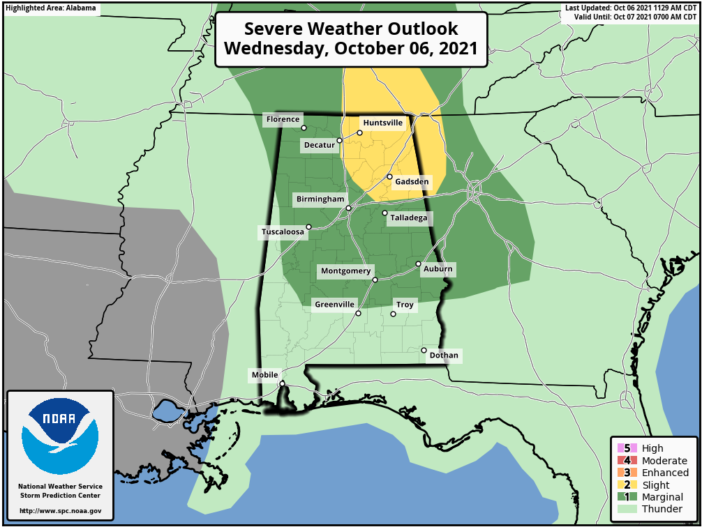
As of the latest update from the Storm Prediction Center, the northeast quarter of North/Central Alabama has been placed in a level 2/5 Slight Risk for severe storms for the remainder of the day, which was upgraded from a level 1/5 Marginal Risk. Much of the rest of the area remains in a Marginal Risk. The Slight Risk includes the cities of Hartselle, Cullman, Huntsville, Guntersville, Scottsboro, and Rainsville in North Alabama, and Gadsden and Anniston in Central Alabama.
Showers and thunderstorms are spotty in coverage for now, but more convection is expected to develop throughout the afternoon and into the early evening hours. Some of the storms may become strong to severe with gusty winds, small hail, and the small risk of a brief spin-up tornado. The greater risk for those stronger to severe storms will be in the slight risk locations, but cannot be ruled out for the marginal risk locations as well.
Here is the text from the latest Day 1 Severe Weather Outlook from the Storm Prediction Center:
THERE IS A SLIGHT RISK OF SEVERE THUNDERSTORMS ACROSS PARTS OF TN/AL/GA
SUMMARY… Isolated severe thunderstorms capable of marginally severe hail, damaging winds and/or a brief tornado are expected across parts of the Tennessee Valley and nearby Southeast States and Lower Ohio Valley, mainly this afternoon through early/mid-evening.
Southeast/Tennessee Valley/Lower Ohio Valley
A closed/vertically stacked low centered over Arkansas and southern Missouri will drift slowly northward today. Regional 12Z observed soundings and WSR-88D VWP data reflect a ribbon of moderately strong low/mid-level southerly winds on the eastern periphery of the cyclone, with these winds primarily spanning Alabama/western Georgia northward into Tennessee and Kentucky. This is coincident with a very moist air mass, which features 850 mb dewpoints in excess of 12C (12Z Birmingham and Atlanta RAOBs) and Precipitable Water values that are in the upper 10-25% of daily climatological values.
Overcast or modestly broken cloud cover generally persists at midday within the broad warm/moist sector. However, additional cloud breaks and a gradual heating of the boundary layer are anticipated through the afternoon, perhaps partially aided by the dry slot that extends into/across Alabama toward northwest Georgia as per midday water vapor imagery.
With little convective inhibition given the moist environment, scattered to numerous thunderstorms will become increasingly prevalent into mid-afternoon. Some marginally severe hail could occur with the western-peripheral low-topped storms across the Tennessee Valley, where low/mid-level lapse rates will be stronger amidst modest-strength effective shear. A more prevalent concern for isolated damaging winds and/or a brief tornado or two may exist across central/northern Alabama and western Georgia into middle/eastern Tennessee this afternoon into evening. Within this corridor, low-level (100-150 m2/s2 0-1 km SRH) and deep-layer winds (35-40 kt effective shear) are expected to be stronger through this evening.
Florida Panhandle
The low near-coastal severe risk from earlier today should further diminish and remain very low owing to shrinking low-level hodograph curvature and the prevalence/influence of slow-moving convection inland.
Category: Alabama's Weather, ALL POSTS, Severe Weather
About the Author (Author Profile)
Scott Martin is an operational meteorologist, professional graphic artist, musician, husband, and father. Not only is Scott a member of the National Weather Association, but he is also the Central Alabama Chapter of the NWA president. Scott is also the co-founder of Racecast Weather, which provides forecasts for many racing series across the USA. He also supplies forecasts for the BassMaster Elite Series events including the BassMaster Classic.Subscribe
If you enjoyed this article, subscribe to receive more just like it.


